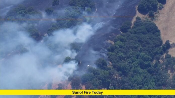

A fast-moving vegetation fire broke out in the Sunol area of Alameda County on Tuesday afternoon, prompting evacuation orders and drawing a large multi-agency firefighting response. As residents search for information on the Sunol fire today, officials say the blaze, named the Little Fire, has grown quickly amid dry vegetation and hot summer conditions in the East Bay hills. This article breaks down what is known so far, including the fire’s location, size, evacuation zones, and the conditions firefighters are working against.
Background on the Little Fire
The blaze that has become the center of the Sunol fire today coverage was first reported by Cal Fire’s Santa Clara Unit at approximately 3:39 p.m. on Tuesday, July 21, 2026. The fire ignited in the area of Little Valley Road and Hubbard Lane, within the unincorporated community of Sunol, which sits south of Pleasanton in Alameda County. The location is notable for its proximity to the Callippe Preserve Golf Course and lies just west of the decommissioned Vallecitos Nuclear Center, a former research facility that has not been operational for years.
Cal Fire’s initial incident reports indicated the fire had already burned roughly 75 to 150 acres within the first hour, with zero percent containment at that stage. By Tuesday afternoon, the fire had grown further, with Cal Fire estimating the burned area at around 400 acres and describing the spread as moderate. Some early reports placed the fire’s footprint even higher, underscoring how quickly conditions were evolving throughout the afternoon. As of the most recent updates available, official containment figures had not been finalized, so there is no official confirmation yet of a full containment percentage.
What Triggered the Rapid Spread
Weather played a significant role in the fire’s early growth. The Little Fire ignited while a National Weather Service heat advisory remained in effect across the Bay Area, with inland temperatures climbing into the mid-90s to low 100s. Meteorologists covering the Sunol fire today noted that vegetation along the Sunol ridgeline was already dry and preheated, conditions that allow flames to ignite quickly and spread at an accelerated pace once wind picks up.
Afternoon winds, which typically strengthen in this part of Alameda County, added another layer of difficulty for crews on the ground. Steep terrain and unpaved access roads in the Sunol Valley further complicated firefighting operations, according to Battalion Chief Raul Medina, who noted that these physical obstacles slowed the ability of ground crews to reach parts of the fire’s perimeter directly.
Firefighting Response and Resources
Multiple agencies mobilized in response to the Little Fire, reflecting the seriousness with which authorities treated the incident. Cal Fire’s Santa Clara Unit led the response alongside the Alameda County Fire Department, with additional support from the Livermore-Pleasanton Fire Department. Aerial firefighting resources, including air tankers, were deployed to help slow the fire’s advance, particularly in the steep and hard-to-reach sections of terrain where ground crews faced delays.
Officials indicated that despite the challenging conditions, crews were making progress in establishing containment lines. Additional resources, including strike teams, were reported to be arriving throughout the afternoon and evening to reinforce suppression efforts. As of the latest reporting, there were no confirmed reports of structures being damaged or destroyed, though this situation may change as assessments continue in the affected area.
Evacuation Orders and Warnings
For residents trying to understand the Sunol fire today, the evacuation zones are the most pressing concern. An evacuation order, meaning an immediate threat to life requiring residents to leave without delay, was first issued for Zone ALC-072. This zone covers the area north of State Route 84 and Vallecitos Road, east of Interstate 680, and south of the Callippe Golf Course.
As the fire expanded, authorities broadened the evacuation order to include additional zones:
Zone PLS-103
Zone PLS-081
Zone PLS-080
These zones stretch east of the golf course toward Isabel Avenue and notably include the Ruby Hill gated community, an upscale residential area on the eastern edge of Pleasanton. In addition to the mandatory evacuation orders, evacuation warnings, which signal a potential threat to life or property, were issued for Zones PLS-082 and PLS-079, areas located south of Vineyard Avenue and east of Bernal Avenue. Residents in warning zones are encouraged to prepare to leave and to pay close attention to updates, especially those who may need extra time to evacuate pets or livestock.
Public Interest and Community Impact
Given its location near populated areas of Pleasanton and the broader Tri-Valley region, the Sunol fire today has drawn considerable public attention. Local news outlets have provided live updates throughout the afternoon, and residents in and around the affected zones have used community alert systems and camera networks, such as those monitored through regional wildfire camera programs, to track the fire’s movement in near real time.
Concerns have also emerged regarding air quality in the surrounding communities, as smoke from the fire may drift into nearby neighborhoods depending on wind direction. While no widespread air quality advisories tied specifically to this fire had been confirmed as of the latest reports, residents in the East Bay may want to monitor local air quality resources if smoke becomes noticeable in their area. The fire’s proximity to the decommissioned Vallecitos Nuclear Center has also generated public curiosity, though there is no official confirmation of any connection between the fire and the former facility beyond their geographic closeness.
Latest Updates
As firefighting operations continued into Tuesday evening, officials described crews as making measurable progress against the blaze, aided significantly by air tanker drops in areas that ground crews could not easily access due to terrain. However, because wildfire conditions can shift rapidly, particularly with wind changes common in the late afternoon and evening hours in this region, the situation remained fluid.
At the time of the most recent reporting, full containment had not been achieved, and evacuation orders for the affected zones remained active. Residents are advised to rely on official sources such as Cal Fire’s incident updates and Alameda County emergency alerts for the most current evacuation status, as conditions tied to the Sunol fire today may continue to evolve.
Final Thoughts
The Little Fire burning near Sunol serves as a reminder of how quickly dry brush, high heat, and shifting winds can combine to create a fast-moving wildfire threat in the East Bay hills. With evacuation orders affecting multiple neighborhoods near Pleasanton, including the Ruby Hill community, and firefighting crews continuing suppression efforts into the evening, the situation remains under close watch by both officials and residents. Anyone in or near the affected zones should stay alert to updates from local fire authorities, as conditions surrounding the Sunol fire today may continue to change in the hours ahead.
Stay safe, stay informed, and be sure to check back for the latest updates on this developing situation — we welcome your thoughts and questions in the comments below.