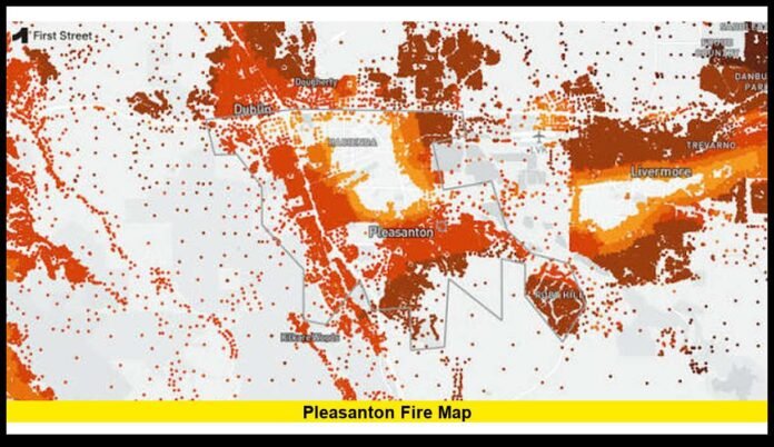

Wildfire activity near Pleasanton has drawn widespread attention as residents monitor evacuation zones, road closures, and changing fire conditions. The latest emergency response centers on the Little Fire, which ignited in southeastern Alameda County and spread rapidly through dry grasslands south of the city. Firefighters continue working to slow the fire’s advance while protecting nearby homes, critical infrastructure, and rural communities. As emergency crews update the incident throughout the day, residents are closely following live mapping tools to understand where the fire is burning and whether evacuation boundaries have changed.
For anyone living in or traveling through the area, understanding the latest fire perimeter and evacuation information remains one of the most important parts of staying safe. Mapping systems continue to evolve as firefighters gather more accurate data from the ground and the air, helping emergency officials make informed decisions about public safety.
Current Fire Situation Near Pleasanton
The Little Fire started in the hills south of Pleasanton near Vallecitos Road and Little Valley Road. The location contains large areas of dry vegetation, making it especially vulnerable during periods of hot weather and low humidity.
Soon after the fire was reported, crews from multiple agencies responded with engines, hand crews, bulldozers, helicopters, and fixed-wing aircraft. Strong firefighting efforts focused on slowing the fire before it could threaten additional neighborhoods.
Smoke quickly became visible across much of the East Bay, with residents in nearby cities reporting a large smoke column rising above the hills. While the most active fire behavior remained outside downtown Pleasanton, nearby communities experienced changing conditions as firefighters expanded operations.
Emergency officials continue monitoring weather patterns that could influence fire behavior throughout the day.
Where the Fire Is Burning
The Little Fire remains concentrated in the rural hills of southeastern Alameda County between Pleasanton and Sunol, burning primarily through open grasslands, grazing land, and rugged terrain. The wildfire is centered near Little Valley Road and Vallecitos Road (State Route 84), where firefighters continue strengthening containment lines and extinguishing hotspots.
The areas receiving the greatest attention include:
- Little Valley Road
- Vallecitos Road (State Route 84)
- Ruby Hill and nearby neighborhoods
- Rural southeastern Alameda County
- Areas approaching Sunol
Although the wildfire has prompted evacuations and heavy smoke across the region, the fire is not burning within downtown Pleasanton or the city’s central neighborhoods. Most fire activity remains in the rural open-space areas southeast of the city. However, residents throughout Pleasanton, Livermore, and nearby communities continue monitoring the situation closely because changing wind conditions can alter fire behavior and smoke patterns.
Firefighters are continually reassessing the fire perimeter using ground crews, aircraft, and infrared mapping to identify hotspots, strengthen containment lines, and determine where additional personnel and equipment are needed. As containment improves, officials will continue updating fire maps, evacuation zones, and public safety information to reflect the latest conditions.
Why Residents Are Following Live Fire Maps
During a fast-moving wildfire such as the Little Fire, conditions can change rapidly. Fire perimeters, evacuation zones, and road closures may be updated several times a day as firefighters gain containment or as changing weather influences fire behavior. For that reason, many residents rely on live fire maps to stay informed and make timely decisions.
Live wildfire maps typically provide:
- Current fire perimeter
- Mandatory evacuation orders
- Evacuation warnings
- Closed highways and local roads
- Evacuation shelters and assistance centers
- Incident boundaries
- Locations where firefighting operations are actively underway
- Updates on fire growth and containment
These real-time mapping tools help residents determine whether their neighborhood is affected, identify safe travel routes, and prepare for possible evacuations. They also reduce the risk of relying on outdated screenshots or unverified information shared on social media.
Because wildfire conditions evolve throughout the day, official mapping systems are updated regularly using information from firefighters on the ground, aerial reconnaissance, infrared mapping flights, and incident command teams. Checking official live maps and emergency alerts frequently is the best way to stay informed as the situation develops.
Evacuation Orders Remain a Top Priority
Protecting lives remains the highest priority during the Little Fire, and emergency officials continue to adjust evacuation zones based on changing fire conditions, weather, and ongoing containment efforts. Evacuation orders and warnings are reviewed regularly to ensure residents have enough time to leave safely if conditions deteriorate.
Officials issued mandatory evacuation orders for neighborhoods facing the greatest immediate threat, including portions of the Ruby Hill area, while surrounding communities were placed under evacuation warnings as a precaution in case the fire spread closer to populated areas.
A Mandatory Evacuation Order means residents must leave immediately because remaining in the area poses a serious risk to life and property. Delaying evacuation until flames or heavy smoke are visible can significantly reduce the time available to leave safely and may hinder emergency responders.
An Evacuation Warning serves as an advance notice that residents should prepare to leave on short notice. This includes packing essential belongings, medications, important documents, pet supplies, and ensuring vehicles are fueled and ready to travel if an evacuation order is issued.
Emergency officials continue to evaluate evacuation zones as firefighters strengthen containment lines and monitor fire behavior. Residents are encouraged to stay informed through official emergency alerts and avoid returning to evacuated areas until law enforcement confirms that it is safe to do so.
Temporary Shelter for Evacuated Residents
Emergency officials established a temporary evacuation support center at the Pleasanton Senior Center (5353 Sunol Blvd., Pleasanton) to assist residents displaced by the Little Fire. The shelter provides a safe location for evacuees while firefighters continue containment operations and emergency managers assess conditions in the affected areas.
The temporary shelter offers basic assistance and serves as an information hub where evacuees can receive updates about evacuation orders, available community resources, and public safety guidance. Families may also use the facility to reconnect with loved ones, charge electronic devices, rest, and obtain information about additional support services if needed.
Many evacuated residents are also using this time to coordinate with relatives, make arrangements for pets and livestock, and stay informed about changing fire conditions. Emergency officials continue to provide regular updates on evacuation zones, road closures, and when it will be safe to return home.
Authorities stress that residents should not attempt to re-enter evacuated neighborhoods until evacuation orders are officially lifted. Returning too early can place both families and emergency responders at unnecessary risk, interfere with firefighting operations, and delay ongoing damage assessments and public safety inspections.
Read More – Sunol Fire Today: Little Fire Prompts Evacuations Near Pleasanton in Alameda County
Road Closures Affect Local Travel
The Little Fire has resulted in temporary road closures and traffic restrictions across portions of southeastern Alameda County to ensure the safety of residents and provide firefighters with uninterrupted access to the incident. As suppression efforts continue, traffic conditions may change quickly depending on fire activity and emergency operations.
Travel impacts include:
- Restricted access near the active fire perimeter
- Temporary closures along Vallecitos Road (State Route 84) and Little Valley Road
- Traffic delays caused by fire engines, bulldozers, helicopters, and other firefighting equipment
- Limited access to rural homes and properties within evacuation zones
- Traffic diversions around emergency response operations
- Road closures associated with mandatory evacuation areas
Authorities continue urging motorists to avoid entering evacuation zones or restricted areas unless specifically authorized by law enforcement or emergency officials. Drivers should expect delays, obey all road closure signs, and follow directions from traffic control personnel.
Keeping roads clear is critical for allowing emergency vehicles, firefighting crews, and evacuation traffic to move safely and efficiently. Residents should monitor official transportation and emergency updates, as roads may reopen or close again depending on changing wildfire conditions and ongoing containment efforts.
Large Emergency Response Continues
The Little Fire has prompted a large regional emergency response, with CAL FIRE, the Alameda County Fire Department, and numerous mutual aid agencies operating under a unified command to protect lives, homes, and critical infrastructure. Firefighters continue working around the clock to strengthen containment lines, extinguish hotspots, and prevent the wildfire from spreading beyond the established perimeter.
Resources assigned to the incident include:
- Wildland fire engines
- Structural fire engines
- Bulldozers
- Water tenders
- Hand crews
- Helicopters
- Air tankers
- Incident management teams
- Command personnel
Aircraft remain especially valuable during periods of active fire behavior. Air tankers conduct repeated fire-retardant drops to slow the wildfire’s advance, while helicopters perform water drops and provide aerial reconnaissance to help incident commanders monitor fire activity and identify emerging hotspots. These aerial operations allow ground crews to safely establish and reinforce containment lines in difficult terrain.
On the ground, firefighters continue patrolling the fire perimeter, extinguishing smoldering vegetation, improving containment lines, and protecting nearby homes and infrastructure. Incident commanders are also closely monitoring weather conditions—including wind speed, temperature, and humidity—to determine where additional personnel and equipment should be deployed as suppression operations continue.
Fire Weather Creates Challenging Conditions
Weather continues to play a critical role in the behavior of the Little Fire, as it does with many California wildfires during the summer fire season. Hot, dry conditions combined with wind have created an environment where vegetation ignites easily and flames can spread rapidly across open grasslands.
Several factors have contributed to the fire’s rapid growth:
- Hot afternoon temperatures
- Dry grasslands and cured annual vegetation
- Low relative humidity
- Gusty winds
- Steep and rugged terrain
Even moderate shifts in wind direction can significantly alter a wildfire’s behavior, pushing flames into new areas, carrying burning embers ahead of the main fire, and creating spot fires beyond established containment lines. These changing conditions require firefighters to continually reassess their suppression strategies and reposition personnel and equipment where they are needed most.
As evening approaches, cooler temperatures and rising humidity generally help reduce fire intensity, allowing crews to strengthen containment lines and extinguish hotspots more effectively. However, officials remain cautious because grass fires can continue to spread under breezy conditions, and flare-ups remain possible until the fire is fully contained. Firefighters will continue monitoring weather conditions around the clock to respond quickly to any changes in fire behavior.
Understanding Fire Perimeter Updates
Many residents notice that wildfire maps can look different from one update to the next. This is normal because fire perimeters are continually refined as emergency crews gather more accurate information about the wildfire’s location, size, and behavior.
Fire perimeters are developed using several sources, including:
- Ground observations from firefighters
- Aircraft reconnaissance
- Infrared imaging flights
- GPS mapping technology
- Reports from firefighting crews and incident command
As new information becomes available, emergency managers update the official fire perimeter to reflect the most accurate picture of the incident. These updates help guide evacuation decisions, resource deployment, road closures, and public safety notifications.
Because perimeter mapping requires data collection, verification, and processing, there can occasionally be short delays between actual fire movement and what appears on public maps. For that reason, residents should treat official fire maps as the best available estimate while also following evacuation orders, emergency alerts, and instructions from fire officials, which may reflect more current conditions than publicly displayed maps.
Air Quality Concerns Across the Region
Even residents well outside the evacuation zones may experience smoke from the Little Fire, as shifting winds continue to carry fine particles across the East Bay. Smoke conditions can change throughout the day depending on wind direction, fire activity, and local weather patterns, causing air quality to vary from one community to another.
Communities across Pleasanton, Livermore, Dublin, Fremont, San Ramon, Oakland, and other parts of the East Bay have reported periods of visible smoke and reduced air quality as the wildfire continues to burn.
The groups most sensitive to wildfire smoke include:
- Older adults
- Young children
- People with asthma
- Individuals with heart or lung conditions
- Pregnant individuals
Health officials recommend that residents experiencing heavy smoke:
- Limit prolonged or strenuous outdoor activities.
- Keep windows and doors closed whenever practical.
- Use air conditioning on recirculation mode or an air purifier if available.
- Wear a well-fitting N95 mask outdoors if smoke levels become unhealthy.
- Monitor local air quality reports and follow public health advisories.
Because wind patterns can shift quickly, smoke conditions may improve in some areas while worsening in others. Residents should continue checking official air quality updates and be prepared for changing conditions until the wildfire is fully contained.
Protection of Homes and Infrastructure
Protecting homes, businesses, and critical infrastructure remains one of the highest priorities for firefighters responding to the Little Fire. While containing the wildfire is a key objective, crews are also working to minimize the risk of damage to nearby communities and essential services.
Firefighters have focused on:
- Defending homes and other residential structures near the fire perimeter
- Protecting utility infrastructure, including power lines and communication equipment
- Preventing spot fires caused by wind-driven embers
- Building and reinforcing containment lines around threatened areas
- Clearing dry vegetation and other combustible fuels near homes and critical facilities
Ground crews, supported by bulldozers and aerial firefighting resources, continue evaluating neighborhoods that could become vulnerable if wind conditions change unexpectedly. Firefighters also patrol the fire perimeter to detect and extinguish hotspots before they can spread beyond established containment lines.
These proactive defensive measures are designed to reduce the likelihood of structural damage during fast-moving grass fires. By protecting homes and strengthening containment around developed areas, emergency crews can better safeguard residents while continuing efforts to bring the wildfire under full control.
Community Preparedness During Active Wildfires
Wildfire preparedness begins well before an evacuation order is issued. For residents living near open grasslands, hillsides, or other wildfire-prone areas around Pleasanton, having a plan in place can make evacuations safer and more efficient when conditions change rapidly.
Preparedness measures include:
- Keeping an emergency supply kit with food, water, medications, flashlights, and important documents.
- Planning multiple evacuation routes in case primary roads become blocked or closed.
- Charging mobile phones, power banks, and other essential electronic devices.
- Preparing pet carriers, leashes, food, water, and veterinary records for quick evacuation.
- Monitoring official emergency alerts from local authorities and CAL FIRE.
- Keeping vehicles fueled during wildfire season and parked for a quick departure.
- Creating a family communication plan so everyone knows where to meet if separated.
- Maintaining defensible space by clearing dry vegetation and combustible materials around homes.
These simple preparedness steps can significantly reduce evacuation delays and improve safety during fast-moving wildfire incidents. Staying informed through official emergency notifications and being ready to leave immediately when an evacuation order is issued helps protect both families and emergency responders.
How Firefighters Build Containment
Containment does not mean a wildfire has been completely extinguished. Instead, it refers to the percentage of the fire perimeter that firefighters believe is surrounded by control lines capable of limiting further spread under expected conditions.
To increase containment, firefighters use a combination of suppression techniques, including:
- Hand crews removing dry vegetation and combustible fuels
- Bulldozers constructing firebreaks in open terrain
- Natural barriers such as roads, rocky areas, or previously burned ground
- Water application from fire engines and helicopters
- Fire-retardant drops from fixed-wing air tankers
- Direct attack on active flames where conditions are safe
As containment increases, incident commanders evaluate whether evacuation zones can be reduced, road closures can be lifted, and residents can safely begin returning to their homes. Before making those decisions, officials inspect affected areas for hazards such as burning debris, weakened trees, damaged utility lines, and lingering hotspots.
Even after a wildfire reaches a high containment percentage, firefighters remain on scene to patrol the fire perimeter, extinguish smoldering vegetation, and monitor for flare-ups that could reignite under changing weather conditions. Full control of a wildfire is only achieved after crews are confident that remaining hotspots no longer pose a significant risk of renewed fire spread.
Why Grass Fires Can Spread Quickly
Grass fires behave differently from forest fires because they burn through fine, fast-drying fuels such as annual grasses and low vegetation. These fuels ignite easily, allowing flames to move rapidly across open landscapes, particularly during periods of hot weather, low humidity, and gusty winds.
Several factors contribute to the rapid spread of grass fires:
- Dry grasses ignite within seconds when exposed to flames or embers.
- Wind can push flames quickly across open terrain and carry burning embers ahead of the main fire, creating new spot fires.
- Rolling hills and steep slopes can increase the fire’s rate of spread by allowing heat and flames to move uphill more rapidly.
- Low humidity and high temperatures dry vegetation even further, making it easier for fires to grow.
Although grass fires can spread quickly, they also tend to lose intensity faster than many forest fires once weather conditions improve and firefighters establish effective containment lines. Rising evening humidity, cooler temperatures, and reduced winds often help slow fire behavior, allowing crews to gain better control of the incident.
To limit fire growth, firefighters rely on a combination of aggressive ground operations and aerial firefighting resources. Air tankers and helicopters slow the fire with water and fire-retardant drops, while hand crews, bulldozers, and fire engines construct containment lines and extinguish hotspots. This coordinated approach is one of the most effective strategies for controlling fast-moving grass fires and protecting nearby communities.
What Residents Should Continue Monitoring
Fire incidents remain dynamic until full containment is achieved.
Residents should continue following updates involving:
- Evacuation changes
- Fire perimeter adjustments
- Road reopening announcements
- Shelter information
- Air quality conditions
- Fire containment progress
- Return-home guidance
Remaining informed helps reduce confusion and ensures families receive the latest safety information as emergency operations continue.
Looking Ahead
Firefighters remain committed to protecting lives, homes, and surrounding communities while working toward full containment. Every wildfire presents unique challenges, particularly when hot weather, dry vegetation, and changing winds combine to increase fire behavior. Continued cooperation between emergency responders and residents plays an essential role in maintaining public safety throughout the incident.
As firefighting operations continue, officials will keep evaluating fire conditions, adjusting evacuation boundaries when necessary, and restoring access to affected areas once it is safe to do so. Residents are encouraged to remain patient, follow emergency instructions, and avoid entering restricted zones until authorities determine that hazards have passed.
Stay connected for the latest updates, and feel free to share your thoughts or local experiences in the comments as the situation continues to develop.