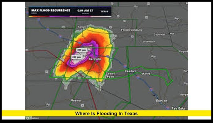

Extreme rainfall has once again placed large portions of Texas under serious flood conditions, leaving residents, travelers, and emergency officials dealing with rapidly changing situations. Many people are trying to understand where is flooding in Texas as rivers overflow, roads disappear beneath rising water, and rescue crews remain active across several counties.
The latest flooding has been concentrated in South-Central Texas and the Texas Hill Country, where repeated rounds of heavy rain have caused rivers and creeks to rise to dangerous levels. Some communities experienced flash flooding within a matter of hours, forcing evacuations and disrupting daily life. While water has begun to recede in certain locations, many rivers remain above flood stage, and authorities continue warning residents to stay alert because conditions can change quickly.
Texas Faces Another Major Flood Emergency
Flooding is one of the most common natural disasters in Texas, but recent weather has created particularly dangerous conditions across parts of the state. A slow-moving weather system delivered repeated thunderstorms over the same regions, producing rainfall amounts far beyond what local waterways could safely handle.
The combination of saturated soil, steep terrain, and overflowing rivers created widespread flash flooding that affected highways, neighborhoods, farmland, parks, and recreational areas.
Emergency management agencies continue monitoring water levels around the clock while local officials work alongside state resources to assist affected communities.
The Hardest-Hit Regions Across Texas
The most significant impacts have occurred across South-Central Texas, although flooding has affected communities across a much broader area.
Several counties continue facing high water levels, damaged roads, and ongoing recovery efforts.
Uvalde County
Uvalde County remains among the areas experiencing the most severe flooding.
Heavy rainfall quickly overwhelmed rivers and drainage systems, leading to widespread road closures and numerous emergency rescues. Low-water crossings became especially dangerous as water rushed across highways faster than drivers could react.
Local emergency crews continue inspecting damaged infrastructure while residents begin cleaning homes and businesses affected by floodwaters.
Medina County
Flooding remains a major concern throughout Medina County.
Numerous creeks overflowed after intense rainfall, sending water into neighborhoods and across rural roadways. Officials continue urging residents to avoid unnecessary travel because hidden road damage and standing water remain serious hazards.
Cleanup operations have started in some locations, but authorities continue monitoring additional rainfall that could slow recovery efforts.
Kinney County
Kinney County experienced rapid flooding after storms delivered significant rainfall across the region.
Many rural roads became impassable, while ranches and agricultural properties sustained water damage. Emergency personnel responded to reports of stranded motorists as floodwaters covered low-lying transportation routes.
Real County
Communities throughout Real County continue dealing with high river levels.
Several streams and rivers rose quickly following repeated storms, creating dangerous conditions for nearby residents. Emergency officials remain prepared for additional rescues should rainfall return to the region.
Edwards County
Floodwaters affected numerous areas of Edwards County, particularly near rivers and smaller creeks that responded rapidly to heavy rainfall.
Transportation remains challenging in certain locations where water damaged roads and bridges.
Bandera County
Bandera County, located within the Texas Hill Country, remains highly vulnerable whenever heavy rain develops.
Steep hillsides channel rainwater into nearby rivers at remarkable speed, increasing the likelihood of flash flooding even after relatively short periods of intense rainfall.
Kendall County
Communities such as Comfort have closely monitored the Guadalupe River as water levels continued rising.
Residents living near waterways have been advised to remain prepared should additional evacuations become necessary.
Kerr County
Although conditions have varied throughout the county, Kerr County remains under close observation because of the Guadalupe River and its long history of significant flooding.
Officials continue tracking river forecasts while encouraging residents to monitor emergency alerts.
Additional Counties Monitoring Flood Conditions
Beyond the hardest-hit locations, several other counties continue experiencing flooding or elevated river levels.
These include:
- Frio County
- Maverick County
- Zavala County
- Val Verde County
- Gillespie County
- Bexar County
- Portions of surrounding South Texas communities
River systems naturally carry floodwaters downstream, meaning communities farther away from the heaviest rainfall can still experience dangerous flooding days later.
Major Rivers Running Above Normal Levels
Texas contains thousands of miles of rivers and creeks, many of which respond rapidly during periods of excessive rainfall.
Among the waterways receiving the closest attention are:
- Guadalupe River
- Nueces River
- Frio River
- Medina River
- San Antonio River
- Pecos River
- Rio Grande in certain areas
Even smaller tributaries have contributed to flooding by carrying enormous volumes of runoff into larger rivers.
Officials continue monitoring river gauges because water levels may continue increasing even after rainfall has ended upstream.
Lampasas River Flow: Flooding Crisis Grips Central Texas
Why the Texas Hill Country Floods So Quickly
The Texas Hill Country is widely recognized as one of the nation’s most flood-prone regions.
Several natural features make the area especially vulnerable.
Rocky limestone beneath the surface prevents rainwater from soaking into the ground efficiently. Instead, water flows rapidly downhill into narrow valleys, rivers, and creeks.
When thunderstorms repeatedly move across the same location, enormous volumes of runoff enter waterways within a very short period.
This explains why rivers in the region can rise dramatically in only a few hours.
Rainfall Totals That Triggered the Flooding
The recent weather system produced exceptional rainfall across parts of South-Central Texas.
Many communities measured well over ten inches of rain during the event, while isolated locations approached or exceeded fifteen inches.
Some thunderstorms produced rainfall at rates of several inches per hour, overwhelming storm drains, creeks, and rivers almost immediately.
Because soils were already wet from previous rainfall, very little additional water could be absorbed into the ground.
Instead, nearly all of the rain flowed directly into waterways.
Emergency Response Continues Across the State
Texas has launched a large-scale emergency response involving local, state, and specialized rescue teams.
Response efforts include:
- Swift-water rescue operations
- High-water rescue vehicles
- Helicopter support
- Emergency medical teams
- Texas National Guard resources
- Search-and-rescue personnel
- Road maintenance crews
- Public safety agencies
Many rescues have involved motorists trapped after attempting to cross flooded roadways.
Others involved residents isolated by rapidly rising water surrounding homes.
Emergency crews continue working around the clock while conditions remain dangerous.
Disaster Declarations Speed Recovery Efforts
State disaster declarations covering numerous counties allow emergency resources to be deployed more efficiently.
These declarations help local governments obtain additional support for emergency operations, debris removal, temporary housing assistance, and infrastructure repairs.
Officials continue assessing flood damage throughout affected communities, and additional counties may receive assistance if conditions worsen.
Transportation Challenges Across Flooded Areas
Flooding has created significant transportation problems across South-Central Texas.
Among the most common issues are:
- Washed-out county roads
- Closed highways
- Flooded intersections
- Damaged bridges
- Unsafe low-water crossings
- Temporary detours
Drivers are reminded that road conditions can deteriorate rapidly during thunderstorms.
Even if a roadway appears open, hidden damage beneath floodwater may make it unsafe to cross.
Transportation departments continue inspecting roads before allowing traffic to return.
Communities Most Vulnerable During Flooding
While flooding can occur almost anywhere after extreme rainfall, certain locations remain especially vulnerable.
These include:
- Neighborhoods along rivers
- Homes near creeks
- Campgrounds
- RV parks
- Agricultural land
- Rural communities
- Recreational parks
- Low-water crossings
Residents living near these locations are encouraged to prepare emergency evacuation plans before severe weather develops.
Weather Conditions Remain a Concern
Although rainfall has decreased across some areas, meteorologists continue watching additional storm systems capable of producing locally heavy rainfall.
Large rivers often continue rising long after the rain has stopped because water from upstream locations continues moving downstream.
This means flooding may develop in areas that did not initially experience heavy rainfall.
Communities downstream should remain alert until rivers return to normal levels.
Flood Safety Remains the Highest Priority
Public safety officials continue emphasizing that floodwaters remain unpredictable and extremely dangerous.
Residents are encouraged to:
- Never drive across flooded roads.
- Avoid walking through moving water.
- Follow evacuation instructions immediately.
- Stay informed through weather alerts.
- Keep emergency supplies available.
- Move vehicles away from flood-prone areas.
- Remain cautious around rivers even after rainfall ends.
Only a small amount of moving water can knock a person off balance, while slightly deeper water is capable of carrying away most passenger vehicles.
Recovery Will Continue for Weeks
As floodwaters slowly recede, recovery efforts are becoming the next major priority.
Local governments and emergency agencies are focusing on restoring normal conditions as quickly as possible.
Current priorities include:
- Removing debris from neighborhoods
- Repairing damaged roads
- Inspecting bridges
- Restoring utilities
- Supporting displaced families
- Evaluating damage to public infrastructure
Some communities may require weeks or even months to fully recover depending on the severity of flooding.
Damage assessments will continue as officials inspect homes, businesses, schools, parks, and transportation networks.
Why Residents Continue Monitoring Flood Conditions
Interest remains high because flood situations can evolve rapidly.
River forecasts are updated regularly as water moves downstream, and additional rainfall can quickly change conditions in communities that previously appeared safe.
Residents, travelers, and businesses continue monitoring forecasts to make informed decisions regarding travel, work, and outdoor activities.
Authorities also stress that recovery operations can temporarily affect transportation, utility services, and access to certain neighborhoods while repairs are underway.
Current Outlook
The immediate threat has begun easing in some areas as rainfall decreases, but several rivers remain above normal levels and continue posing flood risks.
Emergency officials expect recovery efforts to continue while monitoring any additional storms capable of producing localized flooding.
Communities across South-Central Texas remain focused on rebuilding, restoring infrastructure, and assisting residents affected by one of the state’s most significant flooding events of the year.
For anyone wondering where is flooding in Texas, the greatest impacts remain centered across South-Central Texas and the Texas Hill Country, including Uvalde, Medina, Kinney, Real, Edwards, Bandera, Kendall, Kerr, Frio, Maverick, Zavala, Val Verde, Gillespie, and surrounding counties. While conditions continue improving in some locations, ongoing river flooding and recovery work mean residents should remain cautious and follow local emergency guidance until all flood warnings have been lifted.
Have questions about flooding in your area or want to share local updates? Leave a comment below and stay informed as conditions continue to change.