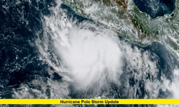

Hurricane Polo remains a major hurricane over the eastern Pacific, after undergoing an extraordinary period of rapid intensification off Mexico’s southwestern coast. The storm briefly reached Category 5 strength, with winds of up to 165 mph, before weakening somewhat while remaining offshore.
The latest information from the National Hurricane Center (NHC) shows that Polo continues to pose significant rainfall, flooding, surf and rip-current hazards along parts of Mexico’s Pacific coast.
Hurricane Polo Storm Update
As of the latest available NHC information for September 23, Hurricane Polo is moving away from its period of peak intensity but remains a powerful system.
Earlier Wednesday, NHC observations placed Polo near 15.0°N, 101.4°W, with maximum sustained winds of about 155 mph and gusts reaching 165 mph. The storm was moving north at approximately 2 mph before forecasters expected it to turn toward the northwest.
Polo had reached Category 5 strength on Tuesday, with maximum sustained winds of 165 mph and a minimum central pressure of 905 millibars.
Polo Became a Category 5 Hurricane Very Quickly
One of the most notable aspects of Hurricane Polo has been its exceptionally rapid strengthening.
Polo developed from a tropical storm into an extremely powerful hurricane in a remarkably short period. The National Hurricane Center documented the storm reaching Category 5 intensity on September 22, after Polo had been considerably weaker only a day earlier.
News reports have described Polo as potentially one of the strongest Pacific storms in decades. Some meteorological analysis has also suggested that its rate of intensification could challenge records for the eastern Pacific, although record comparisons require additional verification.
Where Is Hurricane Polo Now?
Polo has remained offshore of southwestern Mexico rather than making a direct landfall.
The latest NHC forecast indicates that the storm’s core is expected to remain offshore while moving near the southwestern Mexican coast. The system is forecast to turn northwest and then generally west-northwest later in the week.
The storm’s position and slow movement have increased concerns because prolonged rainfall and dangerous ocean conditions can affect coastal communities even when the hurricane’s center remains offshore.
Mexico Faces Heavy Rain and Flooding Threats
The greatest immediate concern for Mexico is not necessarily a direct hurricane landfall but the combination of heavy rainfall, flooding, mudslides, dangerous surf and strong tropical-storm conditions.
The NHC has forecast 3 to 6 inches of rainfall, with isolated totals of up to 8 inches, across coastal portions of Guerrero and Michoacán through Thursday. Areas of Oaxaca, Colima and Jalisco could also receive several inches of rain.
Heavy rainfall can become particularly dangerous in mountainous terrain, where saturated ground and steep slopes increase the risk of flash flooding and mudslides.
Tropical Storm Warning Remains in Effect
A Tropical Storm Warning has been issued for the Mexican coast from Tecpan de Galeana to Punta San Telmo.
A Tropical Storm Watch extends westward from Punta San Telmo toward Playa Perula. The NHC has advised communities along the southwestern Mexican coast to continue monitoring official forecasts because additional changes to watches and warnings could occur.
Residents and visitors in affected areas should rely on local Mexican authorities and official weather agencies for evacuation instructions and other emergency guidance.
Dangerous Surf and Rip Currents Expected
Hurricane Polo is also generating dangerous marine conditions.
The NHC says swells produced by Polo are expected to affect portions of southwestern Mexico during the coming days. These swells can create life-threatening surf, strong rip currents and coastal flooding, even away from the storm’s center.
Marine conditions are especially hazardous for swimmers, boaters, surfers and anyone near exposed beaches or coastal waterways.
Is Hurricane Polo Expected to Make Landfall?
Current forecasts indicate that Polo’s core is expected to remain offshore of southwestern Mexico.
The storm is forecast to turn northwest and later west-northwest, gradually moving farther away from the Mexican coastline. However, remaining offshore does not eliminate the threat because tropical-storm-force winds, rainfall, high surf and coastal flooding can extend well beyond the center.
Forecast confidence can also change as the hurricane interacts with its surrounding atmospheric environment, so residents should continue checking official updates.
Hurricane Polo Forecast Through the Week
The latest forecast guidance indicates that Polo should remain a powerful hurricane as it moves away from the immediate southwestern Mexico coastline.
The NHC forecast shows Polo continuing generally west-northwestward later in the week, with gradual weakening expected in the longer-range period. Marine forecasts also indicate that the hurricane could continue producing significant ocean swells as it moves farther into the Pacific.
Why Hurricane Polo Is Receiving So Much Attention
Polo’s unusually rapid strengthening is a major reason the storm has drawn international attention. It went from a relatively weak tropical system to an exceptionally powerful hurricane in a short period, demonstrating how quickly conditions in the eastern Pacific can change.
The storm also illustrates why residents should not judge hurricane danger solely by whether the center makes landfall. Rainfall, flooding, storm-generated waves and rip currents can create serious hazards far from the eye.
What Residents Along Mexico’s Pacific Coast Should Do
People in areas covered by tropical storm warnings or watches should continue following official instructions and monitor updated forecasts.
Important precautions include avoiding flooded roads, staying away from beaches and dangerous surf, securing loose outdoor objects and preparing for possible interruptions to travel or local services.
The National Hurricane Center emphasizes that people in affected locations should follow information from their local weather and emergency-management authorities.
Bottom Line on the Hurricane Polo Storm Update
The latest Hurricane Polo storm update shows a powerful hurricane that reached Category 5 intensity before weakening somewhat while remaining offshore of southwestern Mexico. Although its center is forecast to stay offshore, dangerous rainfall, flooding, mudslides, surf and rip currents remain important concerns.
Polo’s track and intensity will continue to be closely watched as it turns northwest and moves farther into the Pacific. The latest official advisories should be checked frequently because tropical cyclone forecasts can change as new observations become available.
Stay tuned for the latest Hurricane Polo storm update, and share your thoughts or local weather observations in the comments as the situation develops.