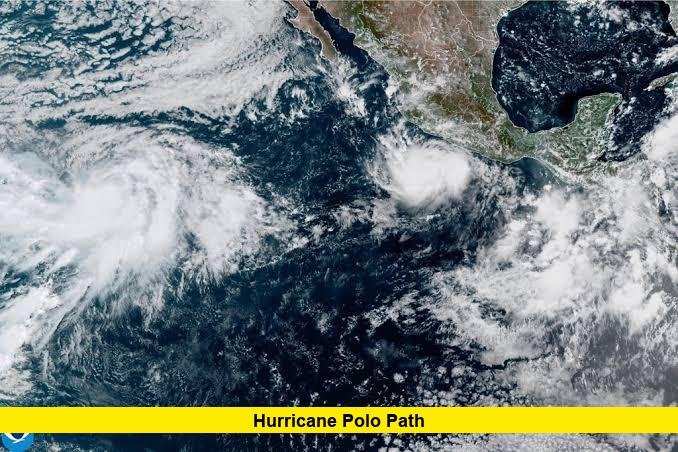

Hurricane Polo path remains a major weather concern as the powerful Eastern Pacific hurricane moves slowly off the southwestern coast of Mexico. The National Hurricane Center (NHC) continues to track Polo as a Category 5 hurricane, with the storm expected to remain offshore while bringing dangerous rainfall, surf and flooding threats to parts of Mexico.
Hurricane Polo Path: Where Is the Storm Now?
The latest available NHC forecast places Hurricane Polo near 15.0°N, 101.4°W, offshore from southwestern Mexico. At the latest advisory reviewed for this update, Polo was moving north at about 2 mph, with maximum sustained winds of 155 mph and higher gusts. Its minimum central pressure was estimated at 918 millibars.
The storm is positioned well offshore but close enough to produce dangerous conditions along portions of Mexico’s Pacific coastline.
Hurricane Polo Forecast Path
The latest forecast shows Polo gradually turning toward the northwest and then west-northwest as it moves away from the immediate Mexican coastline.
According to the NHC forecast track, the center is expected to move:
- Wednesday: Generally northward while remaining offshore.
- Thursday: Turning more toward the west-northwest and moving farther offshore.
- Friday: Continuing west-northwest over the Pacific.
- Saturday: Moving farther west-northwest while gradually weakening.
- Sunday: Continuing westward-to-west-northwestward over the open Pacific.
The NHC’s forecast extends the track well away from a direct landfall scenario, although forecast uncertainty increases farther into the future.
Will Hurricane Polo Make Landfall in Mexico?
Current forecasts indicate that Hurricane Polo’s center is expected to remain offshore rather than make a direct landfall in southwestern Mexico. However, that does not mean coastal communities are outside the danger zone.
Polo’s large wind and rainfall fields can affect areas well away from the eye. Heavy rainfall can trigger flash flooding and mudslides, particularly in mountainous areas. Earlier NHC forecasts warned that the storm’s core could pass close to the southwestern Mexican coast while remaining offshore.
Which Mexican States Could Be Affected?
The greatest concerns remain along parts of Guerrero and Michoacán, where heavy rainfall could create life-threatening flooding and mudslides.
Coastal portions of Oaxaca, Colima and Jalisco can also experience significant rainfall and hazardous marine conditions. The NHC has maintained tropical storm warnings for part of the Mexican coast as Polo moves nearby.
Residents and visitors should pay attention to local Mexican authorities because dangerous conditions can develop even when the hurricane’s center stays over the Pacific Ocean.
Hurricane Polo Rainfall and Flooding Threat
Rainfall is one of the most important hazards associated with the Hurricane Polo path. Forecast information has indicated the possibility of several inches of rain across portions of southwestern Mexico, with locally higher totals possible.
Heavy rain falling over steep terrain can rapidly overwhelm streams and drainage systems. Mudslides and rockslides are also possible in areas where soils become saturated.
For people in affected areas, avoiding flooded roads and following evacuation or emergency instructions from local officials are important safety precautions.
Could Hurricane Polo Affect California?
The current Hurricane Polo path keeps the storm well offshore from the U.S. West Coast. However, forecasters and weather services are monitoring the possibility of large swells, dangerous surf and rip currents along portions of Southern California as Polo moves north and west over the Pacific.
The exact effects will depend on how the hurricane interacts with other weather systems and how its track evolves. Current forecasts do not indicate that Polo’s center is headed directly toward California.
Why Has Hurricane Polo Become So Powerful?
Polo underwent an exceptionally rapid strengthening episode before reaching Category 5 intensity. The storm’s development was supported by very warm ocean water, abundant moisture and favorable atmospheric conditions.
The NHC reported that Polo reached extremely high intensity, with earlier observations showing maximum sustained winds of 180 mph and a minimum central pressure of 892 millibars before some weakening occurred.
As of the latest NHC forecast reviewed for this article, Polo remained an extremely powerful hurricane, although gradual weakening is projected over the coming days.
Hurricane Polo Path: What to Watch Next
The biggest factor to monitor is whether Polo continues following the projected track away from Mexico. Small changes in the hurricane’s direction could alter rainfall and coastal impacts.
The NHC is continuing to issue regular advisories, including forecast-track information, wind probabilities, rainfall information and warnings. Because hurricane forecasts can change as new observations become available, residents in potentially affected areas should use the latest official forecasts rather than relying on an older track map.
The Hurricane Polo path is still evolving, so stay tuned for the latest verified forecast updates and share your thoughts or local weather observations in the comments.