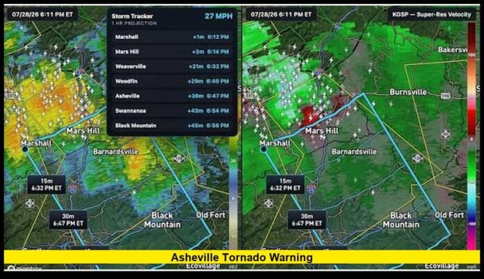

An Asheville tornado warning put parts of Buncombe County and nearby Western North Carolina communities on alert Tuesday evening, July 28, 2026, after radar detected rotation within a powerful thunderstorm. The warning remained in effect until 7 p.m. EDT as the storm moved southeast through the region, bringing dangerous weather and widespread power outages.
The storm developed during an active period of severe weather across the North Carolina mountains. Residents in affected areas received instructions to seek shelter as meteorologists tracked circulation capable of producing a tornado.
Thousands of customers lost electricity during the storms. Emergency officials also began assessing affected areas after the immediate threat moved away.
No major injuries or major structural damage had been declared in the initial official update following the warning. Officials also reported no water rescues at that stage.
What Triggered the Tornado Warning Near Asheville?
The warning resulted from radar-detected rotation inside a severe thunderstorm.
Shortly after 6 p.m. Tuesday, meteorologists were tracking a dangerous storm moving southeast across Western North Carolina. At approximately 6:21 p.m., the thunderstorm was located about seven miles east of Marshall.
The storm was traveling southeast at roughly 30 mph.
Radar data indicated rotation strong enough to create concern about possible tornado development. The warning initially covered southeastern Madison County and central Buncombe County.
By approximately 6:36 p.m., the storm had moved closer to Asheville. At that point, it was located roughly nine miles northeast of downtown.
Residents within the warning area were urged to move to a basement or an interior room on the lowest level of a sturdy building.
The warning continued until 7 p.m.
Was a Tornado Confirmed in Asheville?
A key point about Tuesday’s event is the difference between a tornado warning and confirmation of a tornado touchdown.
The warning was prompted by radar-indicated rotation. That means weather radar detected circulation within the thunderstorm that could support tornado formation.
As of the initial verified information after the warning ended, officials had not announced a confirmed tornado touchdown connected with the Asheville-area storm.
Radar-based tornado warnings still require immediate action.
Tornadoes can form quickly, and residents may have little time to react. A warning allows people to seek shelter before visual confirmation becomes available.
Western North Carolina’s terrain can also make visual identification difficult. Mountains, trees, buildings, heavy rain and low visibility can hide a tornado.
Residents should never wait to see a funnel before taking shelter when their location falls inside a tornado warning.
Areas Threatened by the Storm
The rotating thunderstorm traveled southeast through the mountains and threatened several communities during its progression.
The warning included parts of southeastern Madison County and central Buncombe County.
Locations in or near the storm’s projected path included Asheville, Barnardsville, Flat Creek, Swannanoa, Black Mountain, Montreat and areas near the Blue Ridge Parkway.
The storm also threatened the area around Warren Wilson College.
The exact threat changed as the thunderstorm moved. Tornado warnings generally cover specific polygons based on a storm’s location and projected direction rather than automatically including an entire county.
That means residents should check whether their exact location falls within an active warning.
Read More – Tornado Warning Nebraska: Massive Mesocyclone Produces Tornado as Severe Storms Sweep Across the State
Power Outages Become a Major Impact
Widespread electricity outages emerged as one of the clearest impacts of Tuesday evening’s severe weather.
More than 15,000 customers across Western North Carolina were without power during the storms.
Around 7:15 p.m., more than 12,000 outages were reported in and around Buncombe County.
Severe thunderstorms can cause extensive outages even without a confirmed tornado. Strong wind gusts can bring trees and large branches down onto electrical lines.
Utility poles and other equipment can also sustain damage during intense thunderstorms.
Buncombe County issued an emergency alert after 7 p.m. addressing the outages. At that point, officials did not report evidence of damage to critical power infrastructure.
Crews then faced the task of identifying local damage and restoring service.
Damage Assessments Begin After the Storm
Once the immediate tornado threat ended, emergency officials began evaluating conditions across affected communities.
Buncombe County reported that fire marshals were conducting damage assessments Tuesday evening.
The initial update contained encouraging information. Officials had not declared major injuries or major damage, and no water rescues had been conducted.
Those early findings helped provide an initial picture of conditions after the storm.
Damage assessments remain important because some storm impacts may not become apparent immediately. Fallen trees, roof damage, blocked roads and damaged electrical lines can appear across a large area.
Crews may also need daylight to evaluate some locations safely.
Why Tuesday’s Storm Posed a Serious Threat
Several hazards can accompany a severe thunderstorm capable of rotation.
Damaging winds can break branches, uproot trees and damage buildings. Large hail can damage vehicles, roofs and outdoor property.
Rotation adds the possibility of tornado development.
Wind shear can help thunderstorms rotate when atmospheric conditions support severe weather. Wind shear involves changes in wind direction or speed at different levels of the atmosphere.
A rotating thunderstorm does not always produce a tornado. However, strong radar-indicated circulation can justify a tornado warning because conditions may change quickly.
That was the concern during Tuesday evening’s storm near Asheville.
Asheville Tornado Warning Highlights Need for Immediate Shelter
When an Asheville tornado warning appears on a phone or weather radio, residents inside the warning area should seek protection immediately.
A basement generally provides strong protection in a sturdy building.
Homes without basements still offer shelter options. Residents should move to a small interior room on the lowest floor and stay away from windows.
Interior bathrooms, closets and hallways may provide protection when they have no exterior walls or windows.
People in mobile homes face greater risk during tornadoes and extreme winds. A sturdy nearby shelter provides a safer option when there is enough time to reach it.
Residents should also protect their heads and necks from flying debris.
Tornado Watch and Tornado Warning Are Different
Tuesday’s weather provides a useful example of why residents need to understand weather-alert terminology.
A tornado watch covers a broader region where conditions could support tornado formation. It means residents should stay alert and prepare to act.
A tornado warning carries much greater urgency.
Warnings are issued when meteorologists detect a tornado or identify radar evidence indicating that a tornado may be developing.
Anyone inside the warning area should seek shelter immediately.
The Asheville region faced a broader severe-weather threat before radar detected concerning rotation in the specific storm moving toward Buncombe County.
That development prompted the tornado warning.
Warning Expires at 7 P.M.
The immediate tornado warning ended at 7 p.m. EDT Tuesday.
Its expiration meant the specific tornadic threat that prompted the warning no longer required that warning to remain active.
However, residents still needed to pay attention to other severe-weather alerts.
A Severe Thunderstorm Watch for the Asheville area remained in effect until 8 p.m. Tuesday.
Thunderstorms can continue producing dangerous conditions after a tornado warning expires. Lightning, strong winds, hail and heavy rain can remain hazardous.
Residents should therefore continue monitoring weather alerts until severe conditions have completely moved away.
Why Mountain Communities Can Still Experience Tornadoes
Some people associate tornadoes almost exclusively with flat areas of the central United States.
Western North Carolina’s mountains do not eliminate tornado risk.
Rotating thunderstorms and tornadoes can occur in mountainous areas when atmospheric conditions support their development.
Terrain may influence storm movement and wind patterns, but mountains should never be treated as reliable tornado protection.
Communities including Asheville, Weaverville, Swannanoa and Black Mountain can experience severe thunderstorms capable of producing damaging winds and tornadoes.
Tuesday’s warning reinforced that reality.
Radar Plays a Critical Role in Tornado Detection
Modern Doppler radar allows meteorologists to examine wind movement inside thunderstorms.
Radar can identify areas where winds are moving toward and away from the radar site in patterns that indicate rotation.
That capability is especially valuable when tornadoes cannot be seen easily.
Western North Carolina presents several visibility challenges. Hills and mountains can block long-distance views, while forests and buildings can conceal low-level storm features.
Heavy rain can further reduce visibility.
For that reason, residents should rely on official warning information instead of trying to determine whether a tornado is visible from their location.
Safety Remains Important After a Warning Ends
Storm-related dangers can continue after the weather improves.
Downed electrical lines pose a serious hazard and should always be treated as energized. Residents should keep their distance from fallen lines and damaged utility equipment.
Trees weakened by wind can also remain unstable.
Drivers may encounter fallen branches, blocked roads or intersections where traffic signals are not operating because of outages.
People using portable generators during a power outage should keep them outdoors and well away from windows, doors and other openings.
Generators can produce dangerous carbon monoxide, making indoor operation unsafe.
Preparing for Future Severe Weather in Asheville
Tuesday’s warning shows why households should have several ways to receive emergency weather information.
Wireless Emergency Alerts can deliver tornado warnings to compatible mobile phones. Weather radios provide another useful alert system.
Residents should also identify their safest shelter location before storms arrive.
Waiting until a warning appears to decide where to shelter can waste valuable time.
Families can keep sturdy shoes, flashlights and essential supplies near their shelter area during periods of severe weather.
Phones should remain charged when thunderstorms are expected, especially when storms could cause electrical outages.
Knowing the difference between a watch and warning is equally important. A watch means prepare. A warning means act.
Latest Status Following the Asheville Storm
By Tuesday evening, the tornado warning had expired, and emergency officials had shifted toward assessing storm impacts.
Power outages affected thousands of customers, with Buncombe County experiencing a large concentration of the disruptions.
Fire marshals began evaluating damage after the severe weather moved through.
Initial official information did not declare major injuries or major structural damage. No water rescues had been reported at that stage.
The event demonstrated how quickly a severe thunderstorm can become an immediate public-safety concern.
Radar-detected rotation prompted emergency alerts, residents sought shelter, and widespread outages followed as the storm crossed the Asheville area.
It also reinforced one of the most important rules of tornado safety: a warning should trigger action immediately.
Residents do not need to see a tornado before seeking protection. Radar can identify a dangerous developing situation before a tornado becomes visible or receives confirmation from the ground.
For Asheville and surrounding Western North Carolina communities, staying connected to official weather alerts remains essential whenever severe thunderstorms develop.
Stay alert when severe weather threatens Asheville, and share your local storm experience in the comments while continuing to follow official emergency alerts.