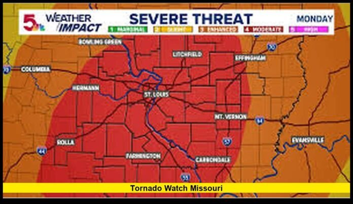

A tornado watch Missouri residents have faced during recent severe weather outbreaks highlights the ongoing threat of dangerous storms across the state as the 2026 severe weather season continues. Multiple rounds of thunderstorms have brought concerns about tornadoes, damaging winds, large hail, flash flooding, and travel disruptions, prompting weather officials to closely monitor conditions and issue alerts when necessary.
Missouri remains one of the most active states in the nation for severe weather. Its location in the central United States places it at the crossroads of competing air masses that frequently create powerful storm systems. During spring and early summer, warm and humid air from the Gulf region often collides with cooler air moving across the Plains and Midwest. These atmospheric ingredients can rapidly produce severe thunderstorms capable of generating tornadoes.
For many residents, a tornado watch serves as an important reminder to stay aware of changing weather conditions and prepare for the possibility of dangerous storms.
Understanding a Tornado Watch
A tornado watch means weather conditions are favorable for tornado formation. It does not mean a tornado is occurring. Instead, it signals that thunderstorms capable of producing tornadoes may develop within the watch area.
Meteorologists issue tornado watches before storms intensify. This advance notice allows residents, businesses, schools, and emergency officials to prepare before severe weather arrives.
When a tornado watch is active, people should:
- Monitor weather updates regularly.
- Review emergency plans.
- Keep phones charged.
- Identify the safest shelter location.
- Be prepared to act immediately if warnings are issued.
Many tornado watches cover large sections of Missouri and may remain in effect for several hours while forecasters track developing storm systems.
Missouri’s Position in Tornado Country
Missouri’s geography contributes significantly to its severe weather risk.
The state sits near the boundary between warm southern air and cooler northern air. During active weather patterns, strong jet stream winds combine with moisture-rich air to create ideal conditions for severe thunderstorms.
Because of these factors, Missouri experiences tornadoes every year. Some tornadoes remain weak and short-lived, while others can become destructive and impact communities across multiple counties.
The risk is not limited to one part of the state. Tornadoes have occurred in urban areas, rural communities, river valleys, and agricultural regions.
This widespread threat makes preparedness important for every Missouri resident.
Recent Severe Weather Patterns Across Missouri
Recent weather activity has demonstrated how quickly conditions can change across the state.
Several rounds of thunderstorms have moved through Missouri during the current severe weather season. These storms have produced strong wind gusts, large hail, heavy rainfall, localized flooding, and tornado concerns.
Many storm systems have developed during the late afternoon and evening hours when daytime heating increases atmospheric instability. Some storms have continued overnight, creating additional challenges for residents who may be asleep when warnings are issued.
Heavy rainfall has accompanied numerous severe weather events. In some areas, repeated thunderstorms have dropped significant amounts of rain within a short period, causing water to accumulate on roads and in low-lying locations.
Emergency officials continue encouraging residents to remain weather aware during active storm periods.
Regions Frequently Included in Tornado Watches
Although tornado watches can affect any part of Missouri, certain regions often experience severe weather activity.
Kansas City Region
Western Missouri frequently experiences severe thunderstorms moving eastward from Kansas and the central Plains. These storms can produce hail, damaging winds, and tornadoes.
Central Missouri
Communities across central Missouri often find themselves in the path of developing storm systems that strengthen as they move across the state.
St. Louis Area
Eastern Missouri can experience severe weather associated with cold fronts and large storm complexes moving across the Midwest.
Southwest Missouri
This region regularly experiences severe thunderstorms capable of producing tornadoes, particularly during the spring season.
Southeast Missouri
The state’s southeastern counties face severe weather threats from systems moving northward from the lower Mississippi Valley.
Regardless of location, residents across Missouri should remain prepared whenever watches are issued.
Atmospheric Ingredients Behind Tornado Development
Several weather elements typically come together before tornado watches are issued.
Moisture
Warm, humid air supplies fuel for thunderstorm development.
Instability
When warm air near the surface rises into cooler air aloft, thunderstorms can develop rapidly.
Wind Shear
Changes in wind speed and direction with height help storms rotate and become organized.
Lifting Mechanisms
Cold fronts, dry lines, and other weather boundaries trigger storm formation.
When all these ingredients overlap, meteorologists may identify an increased risk for tornado-producing storms.
The Difference Between a Watch and a Warning
One of the most important weather safety concepts involves understanding the difference between tornado watches and tornado warnings.
| Tornado Watch | Tornado Warning |
|---|---|
| Conditions are favorable for tornadoes | A tornado has been detected or indicated |
| Covers a large area | Covers a smaller area |
| Prepare and stay alert | Take immediate shelter |
| May last several hours | Usually shorter in duration |
| Potential threat | Immediate threat |
Confusion between these alerts can delay protective actions.
Officials stress that a warning requires immediate action while a watch calls for increased awareness and readiness.
Read More – Weather Storms Tornadoes: Latest U.S. Severe Weather Patterns and What Communities Should Know in 2026
Why Tornado Watches Matter
Some residents may become accustomed to frequent severe weather alerts. However, meteorologists emphasize that tornado watches remain a critical part of the warning process.
A tornado watch provides valuable lead time.
This lead time allows families to:
- Gather emergency supplies.
- Review shelter plans.
- Charge electronic devices.
- Secure outdoor items.
- Monitor developing storms.
Preparedness during the watch stage can make a major difference if a warning follows.
Common Hazards Associated With Tornado Watches
Tornadoes are not the only threat present during severe weather outbreaks.
Storm systems capable of producing tornadoes often bring additional hazards.
Damaging Straight-Line Winds
Strong thunderstorm winds can exceed speeds capable of damaging roofs, trees, and power lines.
Large Hail
Severe thunderstorms can produce hail large enough to damage vehicles, windows, and crops.
Flash Flooding
Heavy rainfall can create dangerous flooding conditions within minutes.
Frequent Lightning
Lightning remains one of the leading weather-related hazards and can strike miles away from the main storm.
Residents should remain aware of all severe weather risks, not just tornadoes.
Emergency Preparedness During Severe Weather
Preparedness remains one of the most effective ways to reduce risk during severe weather events.
Experts recommend that households maintain emergency kits containing:
- Drinking water.
- Nonperishable food.
- Flashlights.
- Batteries.
- First-aid supplies.
- Necessary medications.
- Portable phone chargers.
- Important documents.
Families should also establish communication plans in case family members become separated during an emergency.
Knowing where to shelter before storms arrive can save valuable time.
Best Shelter Locations During Tornado Threats
The safest shelter depends on the type of building.
Homes With Basements
Basements generally provide the highest level of protection.
Homes Without Basements
Residents should move to the lowest floor and choose an interior room away from windows.
Apartments
People living in multi-story buildings should seek shelter on the lowest available floor in an interior area.
Mobile Homes
Mobile homes offer limited protection during tornadoes. Residents should identify a stronger shelter location before severe weather develops.
Planning ahead helps eliminate uncertainty during emergencies.
The Importance of Multiple Warning Methods
Weather experts recommend having several ways to receive alerts.
These may include:
- Wireless emergency alerts.
- Weather radios.
- Television broadcasts.
- Mobile weather applications.
- Local emergency notification systems.
Relying on only one method may increase the risk of missing critical warnings.
Power outages and communication disruptions can occur during severe weather.
Multiple alert sources improve reliability.
Storm Spotters Play a Key Role
Missouri benefits from a large network of trained storm spotters who assist weather officials during severe weather events.
These volunteers provide reports about:
- Funnel clouds.
- Tornado sightings.
- Hail size.
- Wind damage.
- Flooding.
Their observations help forecasters verify storm behavior and improve warning accuracy.
Storm spotters serve as an important link between communities and weather agencies.
How Technology Has Improved Tornado Forecasting
Forecasting technology has advanced significantly over recent decades.
Meteorologists now use:
- Doppler radar systems.
- Advanced weather models.
- Satellite observations.
- High-resolution storm analysis tools.
- Automated weather stations.
These technologies allow forecasters to identify dangerous weather patterns earlier than ever before.
While forecasting continues to improve, severe weather can still evolve rapidly. Residents should remain vigilant whenever tornado watches are issued.
Missouri Communities Continue Strengthening Preparedness
Communities across Missouri continue investing in severe weather preparedness.
Many local governments have enhanced warning systems and emergency response capabilities.
Examples include:
- Outdoor warning sirens.
- Emergency communication networks.
- Public education programs.
- Community shelter planning.
- School safety initiatives.
These efforts help improve readiness throughout the state.
Public awareness campaigns also encourage residents to learn more about tornado safety before severe weather season reaches its peak.
Looking Ahead During the 2026 Severe Weather Season
The severe weather season remains an important period for Missouri residents. Conditions can change rapidly, and strong thunderstorms may develop with little notice during active weather patterns.
Meteorologists continue monitoring storm systems capable of producing tornadoes, damaging winds, hail, and flooding. Tornado watches remain a vital tool for providing advance notice when conditions become favorable for dangerous weather.
For residents across Missouri, staying informed, reviewing emergency plans, and understanding the difference between watches and warnings can make a significant difference during severe weather events. Awareness and preparation remain the strongest defenses when storms threaten communities across the state.
Have severe storms affected your area recently? Share your experience in the comments and stay informed as weather conditions continue to evolve across Missouri.