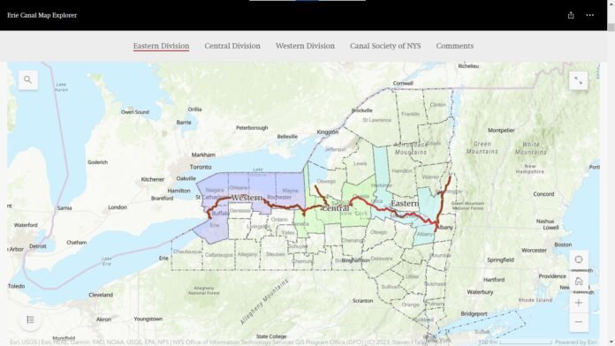

The latest Erie Canal map reflects several verified updates for the 2026 navigation season and continues to serve as one of the most valuable resources for anyone traveling through New York’s historic canal corridor. More than a traditional map, it combines detailed navigation information with current operational data, helping users stay informed about lock operations, lift bridges, navigation hazards, maintenance projects, public docks, marinas, boat launches, Canalway Trail access points, and other essential facilities.
For recreational boaters, the map provides a reliable planning tool for navigating the canal system safely while identifying fuel stops, docking locations, and real-time Notice to Mariners alerts that may affect travel. Cyclists, hikers, and walkers can also use the map to locate trailheads, parking areas, rest stops, campgrounds, scenic overlooks, and connections along the 365-mile Canalway Trail. In addition, history enthusiasts benefit from detailed information about museums, historic locks, interpretive sites, and communities that showcase the Erie Canal’s nearly 200-year legacy.
Because the official map is updated to reflect current operating conditions and infrastructure improvements, it has become an essential companion for planning everything from short day trips to multi-day journeys. Whether exploring the canal by boat, bicycle, or on foot, using the latest map helps travelers make informed decisions, avoid unexpected delays, and enjoy a safer and more rewarding experience across one of America’s most significant historic waterways.
What the Official Map Shows
The official New York State Canal System Interactive Map, maintained by the New York State Canal Corporation, provides a detailed planning tool for boaters, cyclists, hikers, and visitors. It highlights locks, lift bridges, guard gates, marinas, public docks, kayak launches, boat launches, canal speed zones, heritage sites, campgrounds, and Canalway Trail access points, making it easy to plan trips both on the water and along the trail.
The latest 2026 Erie Canalway Map & Guide, published by the Erie Canalway National Heritage Corridor, offers a visitor-friendly overview of the canal network. It combines the historic canal route with modern recreational opportunities, featuring nearby communities, trailheads, parks, visitor services, attractions, and interpretive sites throughout the corridor.
Highlights of the map:
- The Erie Canal stretches approximately 363 miles from the Hudson River at Waterford to Buffalo, linking the Atlantic Ocean to the Great Lakes through New York’s inland waterways.
- The complete New York State Canal System spans 524 continuous miles of navigable waterways, including the Erie, Champlain, Oswego, and Cayuga-Seneca canals.
- The map also showcases the 365-mile Canalway Trail, which follows much of the historic canal towpath and forms part of the 750-mile Empire State Trail, offering extensive opportunities for walking, cycling, running, and sightseeing alongside the waterways.
What’s New or Updated for 2026
Several operational and infrastructure changes are reflected in the official New York State Canal System map and navigation resources for the 2026 season:
2026 Navigation Season
The New York State Canal System opened its 2026 navigation season in mid-May and is operating on its regular seasonal schedule, with most canals open to recreational boating through mid-October. Standard operating hours are generally 8:00 a.m. to 5:00 p.m., although individual locks and lift bridges may follow modified schedules. Boaters should review current operating hours before departing.
Ongoing Lock E-16 to Lock E-17 Project
The major infrastructure project between Lock E-16 (St. Johnsville) and Lock E-17 (Little Falls) remains one of the most significant navigation considerations in 2026. Repairs to the movable dam and associated embankment continue to affect operations in this section of the Erie Canal, with navigation restrictions or closures issued as work progresses. Travelers should verify the latest conditions before planning a trip through this corridor.
Live Notice to Mariners Updates
The official Canal Corporation map is integrated with Notice to Mariners alerts, allowing users to view current operating conditions across the canal system. Updates may include temporary lock closures, bridge inspections, restricted-width passages, underwater inspections, reduced water levels, navigation hazards, debris reports, and special events that could affect travel. These notices are updated throughout the navigation season as conditions change.
Dynamic Travel Planning
Rather than serving only as a static map, the official canal map functions as a real-time planning tool. By combining navigation information with live operational alerts, visitors can identify route changes, maintenance work, temporary restrictions, and reopening notices before setting out, helping both recreational boaters and Canalway Trail users plan safer and more efficient trips.
How to Use the Map of the Erie Canal
The official Erie Canal map is designed for boaters, cyclists, hikers, history enthusiasts, and anyone exploring New York’s iconic waterway. Whether you’re planning a day trip or a multi-day adventure, the map provides the information needed to navigate the canal system safely and efficiently.
For Boaters
The map serves as a valuable navigation resource, displaying locks, lift bridges, public docks, marinas, boat launches, speed zones, and other key infrastructure along the canal. It also integrates live Notice to Mariners updates, allowing boaters to check for temporary lock closures, maintenance projects, navigation hazards, and water level changes before departing. Reviewing the latest map and alerts can help travelers plan lock transit times, identify fuel and docking locations, and avoid unexpected delays.
For Cyclists and Hikers
The map clearly outlines the 365-mile Canalway Trail, indicating where the route follows dedicated off-road paths, quiet local roads, or urban streets. It also identifies trailheads, parking areas, restrooms, campsites, picnic areas, scenic overlooks, visitor centers, and nearby communities, making it easier to organize both short outings and long-distance cycling or hiking trips along the canal corridor.
For History and Heritage Travelers
The Erie Canal map highlights many of the waterway’s historic and cultural landmarks. Visitors can locate original canal alignments, preserved locks, aqueducts, museums, interpretive centers, and historic villages that showcase the canal’s nearly two centuries of influence on New York’s economy and westward expansion. These points of interest make the map an excellent companion for self-guided heritage tours.
For Trip Planning
Beyond navigation, the map functions as a comprehensive travel guide by showing recreational facilities, parks, campgrounds, fishing access sites, kayak launches, picnic areas, and nearby attractions. Combined with real-time operational updates, it helps visitors choose routes, estimate travel times, and adjust plans based on current canal conditions, ensuring a smoother experience whether exploring by boat, bicycle, or on foot.
Key Details at a Glance
| Feature | Latest Information (2026) |
|---|---|
| 2026 Navigation Season | Mid-May through mid-October 2026 (check the official Canal Corporation schedule for exact opening and closing dates). |
| Current Navigation Alerts | Live Notice to Mariners updates provide real-time information on lock operations, maintenance, hazards, and temporary restrictions. |
| Major Infrastructure Project | The Lock E-16 to Lock E-17 section of the Erie Canal remains subject to operational impacts while major repair work continues. Check current alerts before traveling. |
| Erie Canal Length | Approximately 363 miles (584 km) from Waterford on the Hudson River to Buffalo on Lake Erie. |
| New York State Canal System Length | Approximately 524 miles (843 km), including the Erie, Champlain, Oswego, and Cayuga-Seneca canals. |
| Canalway Trail | Approximately 365 miles, forming a major portion of the Empire State Trail. |
| Official Map Features | Locks, lift bridges, marinas, docks, boat launches, Canalway Trail access, parks, visitor services, heritage sites, and real-time navigation alerts. |
Why the Map Matters in 2026
As the Erie Canal bicentennial celebration continues into 2026, the official map has become more than a simple navigation aid. It reflects the ongoing preservation, modernization, and recreational development of one of America’s most historic waterways.
The map is continuously updated to incorporate current navigation conditions, infrastructure projects, and visitor information. With major capital improvements underway on portions of the canal system and seasonal operating schedules that can vary due to maintenance or weather, travelers are encouraged to use the latest version of the interactive map together with Notice to Mariners alerts before setting out.
Beyond boating, the map supports a growing range of outdoor recreation. It connects the 363-mile Erie Canal, the 365-mile Canalway Trail, and communities across the 524-mile New York State Canal System, helping visitors seamlessly plan trips by boat, bicycle, or on foot. It also highlights parks, museums, historic sites, campgrounds, marinas, and trail access points, making it an essential resource for both first-time visitors and experienced canal travelers.
As the canal enters its third century of operation, the official map serves as both a practical travel guide and a gateway to exploring the history, culture, and natural beauty of New York’s iconic canal corridor.
Read Also- Erie Canal — How it’s 200 Years Later Also Shaping Michigan
Summary
The latest Erie Canal map combines detailed navigation information with real-time operational updates, making it an essential resource for anyone exploring New York’s historic canal system. It covers the 363-mile Erie Canal, the 524-mile New York State Canal System, the 365-mile Canalway Trail, and key features such as locks, lift bridges, marinas, trailheads, visitor services, and heritage attractions.
Whether you’re planning a boating trip, a long-distance cycling adventure, a scenic hike, or a visit to the canal’s historic landmarks, the official map helps you navigate safely, stay informed about current conditions, and make the most of your journey. By using the latest interactive map and live navigation alerts, travelers can confidently explore one of the nation’s most iconic waterways as it continues into its third century of operation.
Feel free to comment below with your own experiences using the map or any recent journey you’ve taken along the canal route!