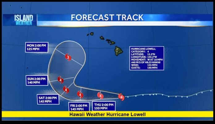

Hawaii weather hurricane Lowell conditions are becoming increasingly serious as the powerful Category 4 storm tracks across the Central Pacific and prepares for a sharp northward turn toward the western Hawaiian Islands.
The latest forecast places Lowell on a path that could bring its closest approach to the western end of the main Hawaiian Islands late Monday and Monday night. Forecasters continue to emphasize uncertainty in the exact track, but the potential for damaging winds, heavy rain, dangerous surf, coastal flooding and storm surge has increased.
As of the latest available Central Pacific forecast information issued Thursday, September 3, Lowell had maximum sustained winds of 120 knots, or about 140 mph, with higher gusts. The hurricane was moving west at roughly 9 knots.
The storm remained several hundred miles south of the Hawaiian Islands. However, its expected change in direction has placed Hawaii under much closer scrutiny heading into the Labor Day weekend.
Want to know what could be ahead this winter? Read our latest winter 2026–2027 snowfall predictions and seasonal weather outlook for the U.S.
Hurricane Lowell Remains a Powerful Category 4 Storm
Lowell has maintained major hurricane strength while moving through an environment with very warm ocean water and substantial ocean heat content.
The latest forecast discussion indicated that the hurricane was dealing with some easterly wind shear and signs of dry-air intrusion. An eyewall replacement cycle had also been observed, with a larger outer eyewall surrounding a weaker inner eyewall.
These internal changes can cause short-term fluctuations in hurricane intensity.
Despite those factors, Lowell remained a formidable major hurricane. The latest intensity forecast kept the system near 120 knots through the first several days before showing gradual weakening later in the forecast period.
That means Hawaii cannot judge the danger simply by assuming Lowell will weaken before reaching the islands.
The latest forecast showed Lowell maintaining hurricane strength as it moves westward through Friday and then begins turning north. The system is expected to accelerate as that turn develops.
The key concern is not only how strong Lowell remains, but also exactly when and where the storm begins its northward movement.
Why Lowell Is Turning Toward Hawaii
Lowell’s track has become more complicated because of changes in the surrounding atmospheric steering pattern.
For much of the storm’s earlier life, a subtropical ridge helped push the hurricane westward. That pattern kept Lowell south of Hawaii.
The forecast now calls for a major change.
An upper-level low moving southward toward the islands is expected to influence Lowell’s steering pattern. As the ridge weakens and the surrounding atmospheric setup changes, Lowell is expected to turn sharply toward the north.
The timing of that turn remains one of the most important forecast uncertainties.
A small difference in when the turn occurs can produce a substantial difference in where Lowell travels relative to Kauai, Niihau and the other Hawaiian Islands.
The National Weather Service Honolulu forecast discussion highlighted that uncertainty while also stating that some effects on Hawaii are likely.
The current forecast places the greatest concern near the western end of the main Hawaiian island chain.
Kauai and Western Hawaii Face the Closest Approach Risk
Kauai County has become a major focus of the latest forecast because Lowell is expected to come closest to the western Hawaiian Islands.
The latest National Weather Service forecast places the closest approach near Kauai County on Monday and Monday night.
At that point, Lowell is forecast to remain a Category 3 hurricane.
That does not mean Kauai will experience a direct landfall.
The current forecast does not establish a confirmed landfall location, and forecasters continue to stress that the exact track remains uncertain.
Instead, the current information indicates that the western islands have the greatest potential for significant effects if Lowell follows the projected path.
Kauai and Niihau could experience stronger winds, larger waves, heavy rainfall and coastal hazards than areas farther east.
Residents across the rest of the state should not assume they are completely outside the threat zone. A shift in the track could change which islands receive the strongest conditions.
Hawaii Weather Conditions Are Already Changing
The effects of Lowell are already influencing weather and ocean conditions across Hawaii.
The strong pressure difference between Lowell and a large area of high pressure north of the islands has increased trade winds.
The National Weather Service reported sustained winds of 20 to 30 mph in portions of Oahu, Maui County and the Big Island, with gusts reaching 50 mph in some areas. A Wind Advisory was in effect for portions of those areas through Thursday night, with the possibility of an extension into Friday.
Trade-wind showers have generally favored windward and mauka areas.
Some showers can reach leeward locations, particularly when stronger winds push moisture across the islands.
The stronger winds also affect aviation and marine conditions. Turbulence can increase near and downstream of higher terrain, while ocean conditions become rougher as winds strengthen.
These conditions are occurring before the hurricane reaches its closest point to Hawaii.
Dangerous Surf Is Already a Major Concern
One of the clearest immediate effects from Lowell is the increasing ocean swell.
The National Weather Service reported that swells generated by Lowell had already reached Hawaii and produced High Surf Advisory conditions along south and southeast exposures.
Those swells can create dangerous breaking waves and powerful currents even when the hurricane itself remains hundreds of miles away.
The threat becomes more serious because additional swell energy is expected as Lowell moves closer to the western islands.
The latest forecast indicates that Lowell-generated swells could remain elevated into next week. Their direction and size will depend heavily on the hurricane’s eventual track and strength.
South-facing and southeast-facing shores are particularly important areas to watch.
People should not judge ocean safety by the weather directly overhead. A sunny beach can still experience dangerous surf generated by a distant tropical cyclone.
Strong rip currents can pull swimmers away from shore quickly.
Beachgoers should follow posted warnings, stay away from hazardous surf and pay close attention to local lifeguard instructions.
Storm Surge and Coastal Flooding Could Become Important
The potential for coastal flooding is another reason the latest forecast deserves close attention.
Storm surge occurs when strong winds push ocean water toward the shoreline. The danger can become greater when surge combines with large waves, high surf and elevated tides.
The National Weather Service Honolulu office warned that coastal inundation could be enhanced by peak monthly high tides expected around Monday.
This timing is important because even a storm that does not make a direct landfall can create serious coastal conditions.
Low-lying coastal areas can face flooding from waves and rising water.
Harbors, beaches, coastal roads and exposed properties can become especially vulnerable when large swells arrive at the same time as high tides.
The final level of coastal flooding will depend on Lowell’s exact track, intensity, size and angle of approach.
For that reason, residents should not use the current forecast as a reason to delay preparation.
Rainfall Could Become a Growing Threat
Rainfall is another major concern as Lowell approaches Hawaii.
The current forecast indicates that portions of Hawaii could experience increased rainfall as the storm moves northward.
The western islands face particular concern because of their projected proximity to the hurricane.
Heavy tropical rainfall can quickly overwhelm drainage systems and produce localized flooding. Steep terrain can also accelerate runoff and increase the potential for hazardous conditions in valleys and low-lying areas.
Rainfall impacts do not require the eye of a hurricane to cross an island.
Outer rainbands can produce periods of intense rain well away from the center.
The exact rainfall distribution will become clearer as Lowell’s track becomes better defined over the weekend.
The Forecast Calls for a Critical Weekend
Friday and Saturday are especially important forecast days because Lowell is expected to transition from its westward movement toward a northward path.
The latest forecast positions show Lowell continuing westward through Friday and then gradually turning northward. By Sunday and Monday, the storm should be moving much closer to the latitude of the Hawaiian Islands.
That means forecast confidence should improve as new observations become available.
For Hawaii residents, the Labor Day weekend is therefore a critical period for monitoring official updates.
The current forecast does not justify assuming that a direct hit will occur. It also does not justify assuming that Hawaii will escape meaningful impacts.
The safest interpretation is that a potentially dangerous hurricane is approaching the western portion of the island chain, with the final outcome still dependent on its track.
No Hawaii-Wide Coastal Watches or Warnings Had Been Issued in the Earlier Update
The City and County of Honolulu said in its September 2 update that no coastal watches or warnings were then in effect for Hawaii. At that time, officials were urging residents to stay informed and use the available time to prepare.
That status should not be interpreted as an all-clear for the days ahead.
Tropical cyclone watches and warnings depend on the forecast distance, timing and expected conditions. They can be issued or expanded as the track becomes more certain.
The situation can change rapidly over several forecast cycles.
Residents should therefore rely on the latest emergency instructions rather than an earlier alert status.
Hawaii Officials Are Urging Residents to Prepare Now
Honolulu officials have encouraged residents to use the lead time before any potential impacts to review emergency plans and supplies.
Recommended preparations include checking food, water, medications and other essential supplies.
Residents should also make sure flashlights, batteries, portable chargers and radios work properly.
Vehicles should have adequate fuel, while households using backup generators should make sure those systems can operate safely.
Family communication plans also deserve attention.
People should know how they will contact one another if cellular service, electricity or internet access becomes unavailable.
Residents who may need additional assistance should also be considered during preparation.
These steps are useful before a storm becomes an immediate emergency because stores, roads and other services can become difficult to access when conditions deteriorate.
Red Cross Prepares for Potential Impacts
The American Red Cross has also moved into a preparation posture because of Lowell’s projected approach.
The organization said it was identifying shelter locations, preparing trained disaster volunteers and positioning relief supplies ahead of the potential impacts during the Labor Day weekend.
The Red Cross emphasized that Lowell might not directly hit Hawaii but could still cause damage.
Its preparation guidance includes having both a shelter-at-home plan and an evacuation plan.
Households should also have enough supplies to manage an extended interruption in power, water, gas, phone or internet service.
A three-day emergency go-kit and a larger supply for staying home can help families respond if normal services are disrupted.
Pet owners and families with children should include their specific needs in emergency preparations.
Marine Conditions Are Becoming More Hazardous
Marine conditions around Hawaii are also being affected by Lowell.
The National Weather Service reported tropical-storm-force conditions in parts of the surrounding offshore waters, while strong winds and increasing seas were creating hazardous conditions for mariners.
A Small Craft Advisory was in effect across Hawaiian waters in the latest Honolulu forecast discussion.
The danger can increase for smaller boats because strong winds, rough seas and large swells can create rapidly changing conditions.
Mariners should monitor the latest marine forecasts and avoid taking unnecessary risks as Lowell approaches.
The ocean response can remain dangerous even when conditions on land appear relatively manageable.
What the Latest Lowell Forecast Means for Hawaii
The latest forecast can be summarized in several key points:
- Lowell remains a powerful Category 4 hurricane.
- Maximum sustained winds were around 140 mph in the latest Thursday forecast.
- The hurricane is moving west but is expected to turn sharply north.
- The closest approach is currently focused on the western Hawaiian Islands.
- Kauai County is among the areas facing the greatest potential for impacts.
- Lowell is forecast to remain a major hurricane for several days.
- The storm could bring dangerous surf, strong winds, heavy rain and coastal flooding.
- High surf conditions are already affecting portions of Hawaii.
- Coastal inundation could become more serious around Monday’s high tides.
- The exact track remains uncertain and could still change.
These details show why the storm deserves close attention without overstating the current forecast.
Why the Next Forecast Updates Matter
Hurricane forecasting becomes more precise as the storm moves closer and new observations become available.
Lowell’s expected northward turn makes that especially important.
If the turn happens earlier, the hurricane could move farther north and closer to the islands.
If the turn happens later, the system could remain farther south before moving north.
The difference between those scenarios can significantly alter wind, rain, surf and coastal flooding conditions.
The storm’s intensity can also change.
Eyewall replacement cycles, wind shear, dry air and ocean conditions can all influence hurricane strength.
For Hawaii residents, the most useful information will therefore come from successive updates from the Central Pacific Hurricane Center, National Weather Service Honolulu and local emergency officials.
Hawaii Residents Should Stay Prepared Through Labor Day Weekend
The latest information does not establish a confirmed direct landfall in Hawaii.
However, it clearly indicates that Lowell could bring serious weather and ocean hazards to parts of the state early next week.
The western islands remain the primary area of concern because of the projected closest approach.
Residents should continue monitoring forecasts through the weekend and follow any watches, warnings or evacuation instructions issued by local authorities.
People should also avoid entering dangerous surf, especially as Lowell-generated swells increase.
The storm’s approach provides Hawaii with valuable preparation time. Using that time now can reduce the pressure on households if conditions worsen later.
Lowell remains a major hurricane, and the forecast is still evolving as the storm approaches the western Hawaiian Islands.
What are you expecting from Hawaii’s weather as Hurricane Lowell approaches? Share your thoughts and stay updated as the forecast develops.