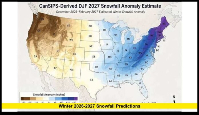

The latest winter 2026 2027 snowfall predictions point to a highly varied U.S. winter, with a very strong El Niño expected to influence storm tracks, precipitation and temperatures across the country. Current climate guidance shows important regional differences, but it does not provide reliable exact snowfall totals for individual cities this far ahead.
The strongest signal heading into the 2026-27 cold season is the rapid strengthening of El Niño in the tropical Pacific. NOAA currently places the probability of a very strong El Niño during the Northern Hemisphere fall and winter above 90%.
The event has already become a major factor in long-range winter forecasting. Ocean temperatures in the equatorial Pacific have climbed well above average, and climate models indicate that the warming will continue into late 2026.
For snowfall, that development matters because El Niño can shift the position of the Pacific jet stream. That shift can influence where storms develop, where moisture travels and which parts of the United States have better opportunities for snow.
However, the current outlook does not support a single nationwide snowfall forecast. Snowfall remains highly dependent on individual storm tracks and temperatures.
A Very Strong El Niño Is Shaping the Winter Outlook
El Niño is currently strengthening, and NOAA’s latest assessment gives more than a 90% chance of a very strong event during fall and winter 2026-27.
NOAA also indicates a significant possibility that the October-through-December period could rank among the strongest El Niño periods observed since modern records began in 1950.
That makes the Pacific Ocean one of the most important factors in the winter forecast.
El Niño develops when unusually warm water spreads across the central and eastern tropical Pacific. The warmer ocean can change atmospheric circulation far beyond the Pacific.
Those changes can influence the jet stream over North America.
For the United States, the result often involves wetter conditions across parts of the southern tier and warmer conditions across portions of the northern half of the country. The exact local response varies from one El Niño winter to another.
This distinction is especially important when discussing snow.
A wetter winter does not automatically mean more snow. Temperatures must also remain cold enough for precipitation to fall and accumulate as snow.
What NOAA’s Current Winter Outlook Shows
NOAA’s Climate Prediction Center has already issued seasonal outlooks covering the upcoming winter.
The current December-January-February outlook favors above-normal temperatures across much of the northern United States and portions of the East. The Southern Rockies remain closer to equal chances for above- or below-normal temperatures.
The precipitation outlook is more favorable for several areas that commonly receive significant winter precipitation.
Above-normal precipitation is favored across California, Arizona, New Mexico, much of Colorado and portions of the Southeast.
This pattern fits the broad precipitation setup commonly associated with a strong El Niño.
The Pacific Northwest and portions of the northern interior United States have a less favorable precipitation signal in the current outlook.
These forecasts describe probabilities rather than guaranteed conditions.
They also do not translate directly into seasonal snowfall totals.
Western U.S. Snowfall Outlook
The West is one of the most important regions to watch during the 2026-27 winter.
Current precipitation guidance favors wetter-than-normal conditions across California and parts of the Southwest. That increases the opportunity for winter storms in mountain areas.
California’s higher elevations could therefore remain an important focus as the season develops.
The Sierra Nevada is particularly sensitive to changes in Pacific storm activity. When moisture-rich systems reach the region while temperatures support snow, major mountain accumulations can occur.
The Southwest also has a favorable precipitation signal in the current seasonal outlook.
Arizona, New Mexico and parts of Colorado are included in the area where above-normal winter precipitation is favored.
For Colorado and nearby mountain regions, precipitation does not guarantee an unusually snowy season at every elevation. Temperature patterns will determine how much of that precipitation falls as snow.
The Intermountain West also remains an important area for winter precipitation.
Long-range forecasts are currently indicating wetter conditions across portions of this region, creating continued potential for significant mountain snowfall during the season.
Pacific Northwest Faces a Different Setup
The Pacific Northwest has a different large-scale outlook.
El Niño winters frequently produce a less favorable precipitation pattern across the Pacific Northwest, and current seasonal guidance shows below-normal precipitation favored in parts of the region.
That does not mean Washington and Oregon will avoid snow.
Mountain areas can still receive major storms, while colder short-term weather patterns can produce snow at lower elevations.
The current seasonal forecast simply does not support declaring an exceptionally snowy winter across the entire Pacific Northwest.
The region’s snowpack will ultimately depend on the timing and intensity of individual storms.
Northeast Snowfall Predictions
The Northeast remains one of the most difficult regions to forecast months ahead.
Current climate guidance favors warmer-than-normal conditions across much of the northern and eastern United States. That creates a challenging setup for persistent snow in many lower-elevation locations.
At the same time, the Northeast can still experience major snowstorms during a relatively warm winter.
The difference between rain, sleet and snow can come down to a small temperature change during an individual storm.
Northern New England and higher elevations have a better chance of maintaining snow because temperatures are generally colder.
Southern portions of the Northeast face a greater risk of mixed precipitation when warmer air moves into the region.
The latest private long-range forecasts are more bullish on snowfall in portions of the Northeast and Appalachians. They identify central New England and areas southward through the Appalachians as locations where above-normal snowfall could occur.
Those private forecasts should be viewed separately from NOAA’s official seasonal outlook because NOAA does not currently issue exact city-by-city seasonal snowfall totals for the entire winter.
Appalachians Could Be an Important Snow Area
The Appalachian Mountains stand out in several current long-range winter forecasts.
Higher elevations naturally provide colder conditions, allowing more winter precipitation to fall and remain as snow.
The current private outlook calls for colder and snowier conditions across portions of the Appalachians, with the northern part of the region receiving particular attention.
For communities in mountainous areas, elevation can make a substantial difference.
A storm producing rain in a nearby valley can produce accumulating snow several hundred or thousand feet higher.
This makes regional snowfall maps more useful for identifying broad trends than predicting conditions at individual towns.
Mid-Atlantic Winter Snow Outlook
The Mid-Atlantic could see a season with considerable swings between mild weather and winter storms.
States including Maryland, Virginia and Pennsylvania can experience rain, sleet or snow from the same storm depending on the position of cold air.
Current forecasts do not justify assigning a specific seasonal snowfall total to major cities such as Washington, Baltimore or Philadelphia.
Instead, the most reliable conclusion is that the region remains highly dependent on individual storm development.
The El Niño-driven southern storm track can provide moisture and storm activity. Cold air must then be present at the correct time for significant snow.
That combination can produce important winter events even when average temperatures remain relatively mild.
Southeast Snowfall Outlook
The Southeast has a wetter signal in the current winter precipitation outlook, but snowfall remains much less certain.
Areas farther north and at higher elevations have better opportunities for snow than coastal and southern locations.
The biggest issue is temperature.
A storm can bring abundant moisture to Georgia, the Carolinas or Tennessee while temperatures remain too warm for accumulating snow.
When a sufficiently cold air mass arrives at the same time as a moisture-rich storm, conditions can change quickly.
The current outlook therefore supports increased attention to winter precipitation across the Southeast but does not establish a nationwide or statewide snow total.
Texas and Oklahoma Winter Outlook
Texas and Oklahoma will also be influenced by the southern storm track.
The current seasonal pattern supports increased precipitation potential across portions of the southern United States. However, temperatures remain the deciding factor for snowfall.
Northern Texas and Oklahoma generally have greater snow potential than southern Texas.
Even so, the seasonal forecast cannot determine how many snowstorms will reach a particular city.
Individual winter storms become much easier to forecast once they enter the shorter-range prediction window.
Midwest and Great Lakes Snowfall
The Midwest faces a mixed winter signal.
Parts of the northern United States are expected to experience warmer-than-normal temperatures, while precipitation patterns vary from west to east.
The Great Lakes region also has an additional snowfall factor that seasonal forecasts cannot resolve: lake-effect snow.
Lake-effect events depend on water temperatures, wind direction, atmospheric temperatures and the exact path of cold air.
A single weather pattern can produce heavy snow in one lake-effect corridor while nearby areas receive little accumulation.
For that reason, a seasonal forecast cannot accurately determine total lake-effect snowfall months in advance.
The Upper Midwest may also experience periods of significant cold and snow despite a warmer overall seasonal temperature signal.
A warmer average does not eliminate short periods of severe winter weather.
Alaska Snowfall Outlook
Alaska’s winter outlook also contains important regional differences.
Current temperature guidance favors above-normal temperatures across broad portions of the state.
That does not mean Alaska will experience a lack of snow.
Much of the state remains cold enough for snow during winter, and local conditions can vary dramatically between coastal and interior areas.
The current seasonal outlook is therefore more useful for identifying broad temperature tendencies than predicting snowfall totals for individual Alaskan communities.
Why Exact Snowfall Totals Are Not Available Yet
One of the most important points in the current winter forecast is the difference between a seasonal climate outlook and a storm-specific weather forecast.
Seasonal models can identify broad probabilities for temperature and precipitation.
They cannot accurately predict every snowstorm several months ahead.
Snowfall depends on several conditions occurring together:
- Cold air must be present.
- A storm must track through the region.
- Enough moisture must be available.
- Temperatures must remain cold enough during precipitation.
- Surface temperatures must support accumulation.
- Local elevation and geography can alter the result.
A small change in storm position can turn a heavy snow event into rain for one city while increasing snowfall only a short distance away.
That is why current forecasts should not be interpreted as exact snowfall calendars.
Private Forecasts Show More Regional Detail
The latest private winter forecasts provide additional regional detail.
The Old Farmer’s Almanac currently describes winter 2026-27 as mostly mild overall but identifies several areas expected to be snowier than normal.
Its current forecast highlights portions of central New England, the Appalachians, the Intermountain region, the Pacific Northwest and Alaska for above-normal snowfall.
It also identifies colder conditions from central New England through the Appalachians and into the Ohio Valley.
Other private forecasting systems have emphasized the potential for enhanced winter precipitation across portions of the Southwest, Central Plains and southern United States.
These forecasts provide additional context, but they should not be confused with guaranteed snowfall totals.
NOAA’s official outlook remains probability-based.
The Most Important Winter Regions to Watch
Based on the current information, several areas deserve particular attention as winter approaches.
California and the Southwest: Current precipitation guidance is favorable, especially for mountain areas.
Southern Rockies: Colorado, New Mexico and nearby mountain areas have an above-normal precipitation signal.
Appalachians: Private forecasts currently favor colder and snowier conditions in parts of the mountain range.
Northeast: Snowfall potential remains highly dependent on storm tracks and temperature.
Southeast: Wetter conditions could provide more winter precipitation opportunities, but temperatures will determine whether storms produce snow.
Pacific Northwest: Current seasonal guidance is less favorable for widespread above-normal precipitation, despite the possibility of individual major snow events.
Upper Midwest and Great Lakes: Short periods of significant snow remain possible even with a warmer seasonal temperature signal.
When the Snow Forecast Will Become Clearer
The winter outlook will continue to change as new observations enter the forecasting systems.
NOAA updates its seasonal outlooks regularly, while shorter-range forecasts will eventually provide much more precise information about individual storms.
The most useful snowfall forecasts will come closer to the event itself.
As winter approaches, forecasters will gain better information about storm tracks, Arctic air masses, atmospheric moisture and temperature profiles.
That will make it possible to identify specific snowstorms with much greater confidence.
For now, the strongest confirmed signal remains the very strong El Niño developing across the tropical Pacific.
Bottom Line on Winter 2026-27 Snowfall
The latest winter 2026 2027 snowfall predictions show a winter shaped by a very strong El Niño, with substantial differences expected between regions of the United States.
The current outlook favors above-normal precipitation across portions of California, the Southwest and Southeast, while parts of the northern United States and Pacific Northwest have less favorable precipitation signals.
Private forecasts identify additional snowier areas, particularly portions of the Northeast, Appalachians, Intermountain West, Pacific Northwest and Alaska.
However, no reliable forecast currently supports exact seasonal snowfall totals for every U.S. city.
The winter pattern will ultimately depend on how the strong El Niño interacts with shorter-term atmospheric conditions. Those details will become clearer as the season gets closer.
Which part of the United States do you expect to see the most snow this winter? Share your thoughts and stay tuned as the 2026-27 winter forecast continues to develop.