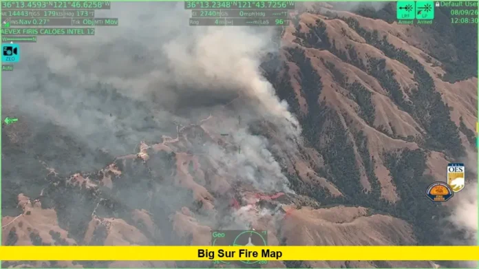

The Big Sur fire map is drawing close attention today as the Timber Fire doubles in size overnight, pushing evacuation orders across multiple zones near the Central Coast. Cal Fire confirmed the blaze had burned roughly 800 acres as of 5:53 a.m. Monday, up sharply from 400 acres the previous evening.
The fire ignited in a remote stretch of the Los Padres National Forest, southeast of the small community of Loma Vista. Officials say that location remains one of the biggest obstacles to containment, since steep slopes and thick brush make it hard for ground crews to get close.
Timber Fire Timeline: How Fast It Has Grown
The Timber Fire started small but escalated quickly across the weekend. Tracking the spread on the Big Sur fire map helps explain why evacuation orders came so fast.
- Saturday, 9:40 p.m. — Fire first reported near Loma Vista
- Sunday, 10:30 a.m. — Fire reaches approximately 100 acres
- Sunday, noon — Growth continues to about 180 acres
- Sunday, 4:30 p.m. — Mapped at 376.4 acres by Cal Fire
- Sunday, 7:25 p.m. — Fire grows to 400 acres, containment at 5%
- Monday, 5:53 a.m. — Fire doubles to roughly 800 acres, containment holds at 5%
That overnight jump from 400 to 800 acres marks the fastest growth period so far, and fire officials have not ruled out further expansion.
Current Evacuation Zones on the Big Sur Fire Map
The Monterey County Sheriff’s Office has issued mandatory evacuation orders for two zones directly in the fire’s path. Anyone checking the Big Sur fire map should note these areas first.
Zones under mandatory evacuation orders:
- MRY-F026
- MRY-F027
These zones sit near Partington Ridge Road and North Coast Ridge Road and include the Alila Ventana Big Sur resort, which was added to the order list Sunday night.
Zones under evacuation warnings:
- MRY-F024
- MRY-F025
- MRY-F028
The warning area has also been extended both north and south of the fire, stretching between the California Coastal Monument and Andrew Molera State Park. Residents in warning zones should stay ready to leave immediately if conditions worsen.
Officials continue urging residents to check Alert Monterey County at alertmry.org/alerts for the most current zone boundaries, since the fire perimeter keeps shifting.
Firefighting Crews Battle Difficult Terrain
Multiple agencies have joined the response effort. Cal Fire, the U.S. Forest Service, the Big Sur Hand Crew, and incarcerated firefighter crews are all working the fire line, supported by air tankers and helicopters.
Los Padres National Forest officials described the terrain bluntly in a Monday social media update, noting the fire is burning in steep, rugged, and difficult conditions that continue to slow suppression work. Because of the fire’s rapid growth, CAL FIRE Incident Management Team 1 has been requested to help manage what officials are calling a rapidly evolving incident.
Ground crews have also reported fire spotting, a pattern where embers jump ahead of the main fire and ignite new pockets of vegetation. This behavior makes it harder to draw a stable line around the fire’s edge, which is part of why containment remains stuck at just 5 percent.
No Reported Injuries or Structure Damage So Far
As of Monday morning, officials have not confirmed any injuries tied to the Timber Fire, nor any destroyed or damaged structures. That is a positive sign given the fire’s size, though officials caution that damage assessments can lag behind real-time fire activity in terrain this remote.
The cause of the Timber Fire remains under investigation. No timeline has been given for when officials expect to determine how the blaze started.
Landmarks Near the Fire Perimeter
Several notable Big Sur locations sit close to the current fire zone, based on the latest Big Sur fire map data:
- Alila Ventana Big Sur resort (inside mandatory evacuation zone)
- Nepenthe restaurant and gift shop
- Post Ranch Inn
- Deetjen’s Big Sur Inn
- Henry Miller Memorial Library
None of these sites have reported damage as of Monday, but their proximity to the fire line explains why officials moved quickly on evacuation orders.
Why the Big Sur Fire Map Keeps Changing
Big Sur’s coastal mountains combine steep canyons, heavy brush, and limited road access, a mix that has fueled major wildfires here before. That terrain is exactly why officials are urging residents to rely on official map updates rather than assumptions based on yesterday’s boundaries.
Cal Fire’s incident updates and Alert Monterey County both push real-time changes to evacuation zones as fire behavior shifts. Checking these sources directly, rather than static images or older articles, gives the clearest picture of which areas are currently affected.
What to Do If You’re Near the Fire Zone
Residents and visitors in or near Big Sur should take a few practical steps while the Timber Fire remains active:
- Sign up for alerts through Alert Monterey County at alertmry.org/alerts
- Follow the Monterey County Sheriff’s Office on social media for real-time updates
- Keep vehicles fueled and important documents ready if you’re in a warning zone
- Avoid nonessential travel into affected areas along Highway 1
- Check Cal Fire’s incident page for the latest acreage and containment numbers
Conditions in this part of the Los Padres National Forest can change within hours, so officials recommend checking updates multiple times a day rather than relying on a single report.
Looking Ahead for the Timber Fire
With containment still at just 5 percent after the fire doubled overnight, firefighters face a demanding stretch ahead. Weather, wind direction, and continued access challenges will likely shape how quickly crews can gain ground on this blaze.
Big Sur has seen major wildfires before, and local agencies bring experience managing fires in this exact kind of terrain. Even so, the jump from 400 to 800 acres in a matter of hours is a reminder of how quickly the situation can shift here.
Keep checking back for the latest on the Timber Fire and share your thoughts or updates in the comments below.