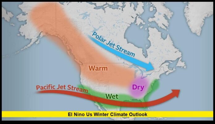

The El Niño US winter climate outlook points toward a winter with a distinctive weather pattern across the country, including above-average temperatures across much of the northern United States and increased precipitation chances across the southern states and East Coast. The developing El Niño is expected to remain a major influence on U.S. weather through the winter and into early 2027, potentially affecting storm tracks, drought conditions, rainfall, snowfall opportunities, and regional temperature patterns.
The latest outlook for December 2026 through February 2027 indicates that a strong El Niño is shaping the seasonal forecast. While some areas may experience milder-than-average winter conditions, others could see more frequent storms and periods of heavy precipitation. However, seasonal forecasts describe probabilities rather than guaranteeing specific weather conditions on any particular day.
For Americans preparing for winter travel, holiday plans, heating expenses, outdoor activities, or potential flooding, the latest climate outlook offers important clues about what may lie ahead.
What the Latest El Niño US Winter Climate Outlook Shows
The current outlook highlights several major regional trends for the upcoming winter:
- Warmer-than-average temperatures: Favored across much of the northern United States, including the Pacific Northwest, Great Lakes, Northeast, and Upper Mississippi Valley.
- Above-average precipitation: More likely across California, the Southwest, southern Great Plains, Southeast, and much of the East Coast.
- Potential drought improvement: Several drought-affected areas across the Southwest, Southern Great Plains, Southeast, and East could receive beneficial precipitation.
- Drier conditions in selected northern regions: Parts of the northern Rockies, Northern Great Plains, Great Lakes region, and Alaska have increased chances of below-average precipitation.
- A strong El Niño influence: The climate pattern is expected to be a major driver of U.S. temperature and precipitation patterns through the winter.
The outlook is based on the latest seasonal climate guidance available as of November 21, 2026, and reflects forecast probabilities rather than a precise day-by-day weather prediction.
Why El Niño Could Shape the 2026–2027 Winter
El Niño is a climate pattern that develops when ocean temperatures in the central and eastern tropical Pacific become warmer than normal and interact with changes in atmospheric circulation. These changes can influence the position of the jet stream, which helps determine where storms travel across North America.
During a strong El Niño, the jet stream often shifts southward and eastward, creating a more active storm track across parts of the southern United States. This can increase the likelihood of rain and storm systems in areas that might otherwise experience drier conditions.
For the 2026–2027 winter, forecasters expect El Niño to be a particularly important influence. The climate pattern has strengthened considerably, and official projections indicate that strong-to-very-strong El Niño conditions are likely to continue through early 2027.
That does not mean the entire country will experience the same weather. The United States is geographically diverse, and winter conditions can vary significantly between the Pacific Northwest, the Plains, the Great Lakes, the Southeast, and the Northeast.
El Niño Status: A Strong Climate Pattern Is Expected to Continue
The latest climate assessment indicates that El Niño is continuing to strengthen. The November outlook suggests that strong-to-very-strong El Niño conditions are likely through January–March 2027, with the climate pattern expected to remain influential during the winter season.
Forecasters are also monitoring the possibility that this event could become historically strong. The current probability estimates indicate a meaningful chance of reaching exceptionally strong territory, although the final strength and duration of the event remain uncertain.
The latest official El Niño monitoring information is available through the Climate Prediction Center’s ENSO diagnostic discussion.
The important distinction for the public is that a strong El Niño increases the likelihood of certain seasonal weather patterns but does not determine every storm, cold outbreak, or snowfall event.
Northern United States Could Experience a Warmer-Than-Average Winter
One of the clearest signals in the 2026–2027 outlook is the increased probability of above-average temperatures across much of the northern United States.
Regions with elevated chances of a warmer-than-normal winter include:
- Pacific Northwest
- Northern California
- Northern Rockies
- Great Lakes
- Upper Mississippi Valley
- Midwest
- Northeast
- Much of the northern and central portions of the country
- Alaska, particularly parts of central and eastern Alaska
The outlook particularly favors above-average temperatures across the Northeast, Great Lakes, Upper Mississippi Valley, and Pacific Northwest.
For residents in these areas, the seasonal forecast suggests that the winter average temperature could finish warmer than the long-term climate average. This could mean more frequent mild periods, less persistent cold in some locations, or temperatures fluctuating between warmer spells and occasional colder weather.
However, warmer seasonal averages do not eliminate the possibility of significant winter storms. A region can experience an overall warmer winter while still receiving snow, freezing rain, or temporary Arctic air outbreaks.
Pacific Northwest: Milder Temperatures but Wet Weather Potential
The Pacific Northwest is among the regions where warmer-than-average temperatures are favored.
Washington and Oregon could experience a winter with more frequent mild conditions than would typically be expected during a colder seasonal pattern. At the same time, precipitation forecasts suggest that parts of the West Coast could experience wetter-than-average conditions.
This combination could produce a complicated winter for the region. Higher temperatures may influence snow levels in the mountains, while rainfall could increase the risk of flooding in areas vulnerable to prolonged precipitation.
Residents should not assume that a warmer forecast means a dry or storm-free winter. Mountain snow, heavy rain, windstorms, and localized flooding remain possible.
California and the Southwest Could See Increased Precipitation
California and parts of the Southwest are among the regions expected to have increased chances of above-average precipitation during the upcoming winter.
The seasonal outlook indicates a wetter-than-average pattern may develop across California, southwestern Oregon, the Southwest, and parts of the southern United States. The latest guidance also shows increased precipitation probabilities in parts of southern California and southwestern Arizona.
For drought-affected areas, additional rainfall and mountain snowfall could provide important water benefits.
However, increased precipitation can also create hazards. Heavy rainfall may cause flooding, especially in locations with steep terrain, burn scars, poor drainage, or saturated ground.
A wetter winter is not automatically a safer winter. The timing, intensity, and location of precipitation will determine whether it produces beneficial water supplies or dangerous flooding conditions.
Southern Great Plains: Rain Could Help Drought Conditions
The Southern Great Plains are another region where the El Niño US winter climate outlook favors increased precipitation.
Parts of Texas, Oklahoma, and surrounding areas may experience wetter-than-average conditions during the winter months. The increased precipitation could help replenish soil moisture and improve drought conditions in areas that have experienced extended dry periods.
The potential benefits include:
- Improved soil moisture for agriculture
- Greater opportunities for drought relief
- Increased water availability in some reservoirs and watersheds
- Reduced stress on vegetation and ecosystems
Yet precipitation could arrive unevenly. Some locations may receive meaningful rainfall while others remain relatively dry. A seasonal forecast cannot determine exactly which cities, counties, or individual communities will receive the most precipitation.
Southeast Could Experience a Wetter and More Active Winter
The Southeast is expected to be one of the regions where the El Niño influence may be particularly noticeable.
Florida, southern Georgia, and parts of the coastal Carolinas have some of the strongest probabilities of above-average winter precipitation in the latest seasonal outlook. The broader region, including portions of the Gulf Coast and Southeast, could experience an increased frequency of wet weather systems.
This could bring potential drought relief to parts of the region, but it may also increase concerns about:
- Heavy rainfall
- Localized flooding
- River flooding
- Waterlogged soils
- Transportation disruptions
- Coastal weather impacts
The seasonal forecast suggests that precipitation is a stronger signal than temperature for many areas of the Southeast. Temperatures may vary considerably depending on individual weather systems and the movement of cold air into the region.
Florida Could See One of the Strongest Wet-Weather Signals
Florida stands out in the current winter precipitation forecast.
The latest seasonal outlook indicates greater than 70% probabilities of above-normal precipitation in parts of Florida, with similarly elevated probabilities across southern Georgia and the coastal Carolinas.
For Florida residents, this could mean a greater likelihood of a wetter-than-usual winter season. While winter rainfall can be beneficial for water supplies and drought conditions, periods of heavy rain may create localized flooding problems.
The forecast does not mean Florida will experience continuous rain. Instead, it indicates that the total precipitation accumulated over the December-through-February period is more likely to exceed the typical seasonal amount.
Residents should monitor local forecasts, particularly when heavy rainfall is expected to coincide with high tides, drainage problems, or vulnerable roadways.
East Coast: Increased Chances of Rain and Storm Systems
The East Coast is also included in the wetter-than-average precipitation outlook.
From portions of the Mid-Atlantic to the Northeast, seasonal guidance indicates increased chances of precipitation. The El Niño pattern could support an active storm track that brings more frequent weather systems to parts of the eastern United States.
Potential impacts could include:
- Periods of heavy rain
- Coastal storms
- Wind-driven precipitation
- Flooding in vulnerable locations
- Snow or mixed precipitation during colder periods
The exact winter outcome will depend heavily on atmospheric conditions that can change from week to week.
A wetter seasonal forecast should not be interpreted as a prediction that every East Coast storm will be rain. Cold-air availability, storm track position, and local temperatures will determine whether precipitation falls as rain, snow, sleet, or freezing rain.
Great Lakes and Northern Rockies Could Be Drier
While the southern United States and much of the East have increased chances of above-average precipitation, some northern regions are expected to have a different pattern.
Parts of the Great Lakes, Northern Rockies, Northern Great Plains, and mainland Alaska are favored for below-average precipitation.
This does not mean these regions will be snow-free. Snowstorms can still occur, even in a season that ultimately records below-normal total precipitation.
The seasonal outlook is focused on the accumulated precipitation over the entire winter. A region with a below-average precipitation forecast could still experience one or more significant snowstorms.
Will El Niño Mean Less Snow Across the United States?
One of the most common questions about the El Niño US winter climate outlook is whether the climate pattern means less snow.
The answer is not necessarily.
El Niño can influence the storm track and the average temperature pattern, but snowfall depends on several factors working together:
- Temperature during precipitation
- Storm track
- Availability of cold air
- Moisture levels
- Elevation
- Local atmospheric conditions
A warmer-than-average seasonal forecast does not mean that a city will avoid snow. Significant snowstorms can occur during an El Niño winter, particularly when cold air temporarily moves into the region.
Seasonal climate forecasts also cannot reliably predict how much snow a particular city will receive months in advance. Snowfall forecasts become more useful when individual weather systems are closer to arriving.
For those interested in specific snowfall predictions, local forecasts and short-range winter storm guidance are more useful than a three-month climate outlook.
Drought Conditions Could Improve Across Several Regions
One of the potentially positive consequences of the expected wetter pattern is drought relief.
The latest drought outlook favors improvement or the end of drought conditions in parts of the:
- Southwest
- Southern Great Plains
- Southeast
- East Coast
Areas experiencing dry conditions could benefit from increased rainfall and snowfall, particularly if precipitation is spread across multiple weather systems throughout the season.
However, drought recovery is not guaranteed simply because a seasonal outlook favors above-average precipitation. The severity of existing drought, soil conditions, reservoir levels, and the timing of rainfall all matter.
In some areas, heavy rainfall could produce flooding before water supplies and long-term drought conditions fully recover.
Could the Winter Still Bring Extreme Cold?
Yes. A warmer-than-average seasonal forecast does not eliminate extreme cold weather.
Winter temperatures are influenced by several atmospheric patterns in addition to El Niño, including the Arctic Oscillation and North Atlantic Oscillation. These patterns can affect whether Arctic air moves south into the United States and how long cold outbreaks persist.
A strong El Niño can influence the overall winter pattern, but temporary atmospheric shifts may still produce:
- Arctic air outbreaks
- Hard freezes
- Snowstorms
- Ice storms
- Sudden temperature drops
The seasonal forecast should therefore be viewed as a broad probability pattern, not a guarantee of mild weather every day.
What the Outlook Means for Winter Travel and Holiday Plans
The forecast could have practical implications for people traveling during Thanksgiving, Christmas, New Year’s Day, and throughout the winter season.
Travelers in wetter regions should be prepared for heavy rain, flooding, and changing road conditions. Those traveling through northern states should remain alert for snowstorms and sudden cold outbreaks even if seasonal temperatures are expected to be above average.
Air travelers should also remember that a warmer winter does not necessarily mean fewer delays. Storms, high winds, rain, snow, ice, and low visibility can disrupt flights in any winter climate pattern.
For road trips, drivers should continue to carry winter emergency supplies when traveling through areas where snow, freezing rain, or cold conditions remain possible.
The National Weather Service provides regional forecasts, weather alerts, and winter safety information through its official weather and preparedness resources.
How Reliable Are Seasonal Winter Forecasts?
Seasonal forecasts are useful for identifying broad climate trends, but they are not designed to predict individual weather events.
A forecast showing above-average temperatures means that the seasonal average is more likely to fall within the warmer portion of the historical range. It does not mean every day will be warmer than normal.
Similarly, above-average precipitation probabilities do not indicate that rain or snow will occur every week. A season could have several dry periods interrupted by a small number of major storms that contribute significantly to the total precipitation.
The official Climate Prediction Center seasonal outlook provides updated seasonal probability maps and forecast discussions.
These forecasts are updated periodically as new observations and modeling information become available. As winter progresses, shorter-range forecasts will provide increasingly useful information about individual storms, cold outbreaks, snowfall, and flooding risks.
What Americans Should Watch Next
As the 2026–2027 winter approaches and progresses, several developments will be important to monitor:
El Niño’s strength: Changes in Pacific Ocean temperatures could influence how long the climate pattern remains strong and how it affects the jet stream.
December weather patterns: The beginning of winter may help reveal whether the expected seasonal pattern is developing as forecast.
Cold-air outbreaks: Temporary changes in atmospheric circulation could bring significant cold to regions forecast to have warmer seasonal averages.
Rainfall and drought conditions: Wetter conditions could help drought-stricken regions, but heavy rainfall may create flash flooding and other hazards.
Regional snowfall forecasts: Snowfall expectations will become more reliable as individual storm systems move into the forecast window.
Monthly climate updates: Seasonal outlooks are revised as new observations, model forecasts, and atmospheric developments become available.
The latest NOAA winter forecast information can be reviewed through its official U.S. Winter Outlook.
El Niño US Winter Climate Outlook: What to Expect Overall
The latest El Niño US winter climate outlook suggests that the 2026–2027 winter could feature a relatively warm pattern across much of the northern United States, while increased precipitation chances extend across California, the Southwest, the southern Plains, Southeast, and East Coast.
The strongest seasonal signals currently point toward above-average temperatures in much of the northern U.S. and wetter-than-average conditions across large portions of the southern and eastern country. Some northern areas, including parts of the Great Lakes and Northern Rockies, may instead experience below-average precipitation.
The outlook could bring drought relief to several regions, but it also highlights the possibility of heavy rain, flooding, winter storms, and periods of extreme cold despite the broader El Niño pattern.
As the winter season unfolds, updated regional forecasts will become increasingly important for determining the weather conditions communities will actually experience.
What are you expecting from the 2026–2027 winter—milder temperatures, heavy rain, major snowstorms, or an unexpected cold outbreak? Share your thoughts and stay tuned for the latest winter climate updates.