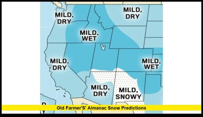

Old Farmer’s Almanac snow predictions for the 2026–2027 season show a winter shaped by strong regional differences, with above-normal snowfall expected in several parts of the United States and below-normal snow forecast elsewhere.
The latest long-range winter outlook does not point to a uniformly snowy or snowless season. Instead, the forecast identifies specific regions that could receive more snow than their historical averages and others that may finish the season with less.
The Appalachians, Pacific Northwest, Intermountain West and Alaska are among the areas with an above-normal snowfall outlook. Parts of the Northeast also stand out, although snowfall expectations vary sharply between northern and southern sections.
Meanwhile, the High Plains, Deep South and Desert Southwest are among the regions expected to lean toward below-normal snowfall.
2026–2027 Winter Snow Forecast at a Glance
The latest outlook provides a broad picture of how snowfall could be distributed across the country.
| Region | Expected snowfall pattern |
|---|---|
| Northeast | Mixed; south above normal, north below normal |
| Atlantic Corridor | Slightly below normal |
| Appalachians | Above normal |
| Southeast | Near normal |
| Lower Lakes | Near to below normal |
| Ohio Valley | Slightly below normal |
| Deep South | Below normal |
| Upper Midwest | Near to below normal |
| Heartland | Near to below normal |
| Texas-Oklahoma | Near normal |
| High Plains | Below normal |
| Intermountain West | Above normal |
| Desert Southwest | Below normal |
| Pacific Northwest | Above normal |
| Pacific Southwest | Near to above normal in mountain areas |
| Alaska | Above normal |
The map of expected snowfall is therefore highly uneven.
Some of the nation’s traditionally snowy locations could receive less snow than normal, while several western and mountainous areas could experience an active season.
The Northeast Could Have Two Very Different Winters
The Northeast is one of the most complicated regions in the latest outlook.
Northern sections are expected to receive below-normal snowfall, while southern portions are forecast to receive above-normal snowfall.
The temperature outlook also differs across the region. Southern areas are expected to run colder than normal, while northern sections could be warmer.
Several periods are highlighted for increased snow activity, including the middle and latter parts of December, mid-January and early and late March.
This does not mean that every storm during those periods will produce heavy accumulation.
Instead, the forecast identifies them as the portions of the season when snowfall potential could become more significant.
The final outcome will depend heavily on the exact paths and strength of individual storms.
Appalachians Among the Strongest Snow Areas
The Appalachian region has one of the more favorable snowfall outlooks for the coming winter.
The latest forecast expects below-normal temperatures and above-normal snowfall, especially across northern sections of the Appalachians.
Mid-January and early and late February are identified as important periods for snow.
That combination could make the Appalachians one of the more consistently wintry areas of the country.
Elevation will also play an important role.
Higher locations can accumulate snow even when nearby lower elevations receive rain or mixed precipitation.
Pacific Northwest Has an Above-Normal Snow Signal
The Pacific Northwest is another region where snowfall is expected to exceed normal levels.
The outlook includes Washington, Oregon and Idaho in an area projected to receive above-normal snowfall.
The temperature forecast, however, calls for warmer-than-normal conditions overall.
That may seem contradictory, but seasonal temperature averages do not determine snowfall by themselves.
Individual storms can still bring cold air and substantial precipitation.
Late December, mid-January and mid-February are highlighted as periods when snow could become more active.
Mountain communities are likely to remain particularly sensitive to changes in storm tracks and freezing levels.
Intermountain West Could See a Snowier Winter
The Intermountain West also has an above-normal snowfall forecast.
The region is expected to be warmer and wetter than normal overall, while snowfall could exceed the seasonal average.
The forecast identifies late November, late December and early February as notable periods for snow.
The region’s terrain makes snowfall highly dependent on elevation.
Mountain areas can receive substantial accumulations while lower elevations experience rain or a mixture of winter precipitation.
For that reason, the regional outlook should not be interpreted as an identical prediction for every city or community.
Alaska Could Receive More Snow Despite Warmer Temperatures
Alaska is expected to have above-normal snowfall during the upcoming winter.
At the same time, temperatures are projected to remain above normal overall.
Several periods could bring stronger snowfall activity, including mid-November, early and late January, mid-February and late March.
Precipitation is not expected to be uniform throughout the state.
Northern areas are forecast to be wetter, while southern sections could experience drier conditions.
Alaska therefore joins the Pacific Northwest and Intermountain West as another example of a region where above-normal snowfall can occur despite a warmer seasonal temperature pattern.
Pacific Southwest Mountain Snow Could Stay Near or Above Normal
The broader Pacific Southwest is expected to be warmer and wetter than normal.
However, mountain areas that typically receive winter snow could see near- to above-normal snowfall.
The most notable periods include late December, mid-January, early and late February, and early and late March.
The mountain-versus-lowland difference is important when interpreting this part of the forecast.
A warmer overall winter does not necessarily eliminate mountain snow. Higher elevations can continue to receive significant accumulation during individual storms.
Where Is Less Snow Expected?
Not every part of the United States has a favorable snowfall outlook.
The latest forecast points to below-normal snowfall in several areas.
The High Plains are expected to experience warmer and drier conditions with snowfall below normal.
The Desert Southwest is also expected to have below-normal snowfall.
The Deep South has a similar below-normal snowfall signal.
The Atlantic Corridor is projected to finish slightly below normal, while the Upper Midwest and Heartland lean toward near- to below-normal snowfall.
These predictions refer to seasonal totals.
They do not rule out individual snowstorms.
A region can experience a major snow event and still finish the winter below its historical average if other parts of the season remain relatively quiet.
Ohio Valley Forecast Shows Why Snow and Cold Are Different
The Ohio Valley provides one of the clearest examples of why snowfall and temperature forecasts need to be considered separately.
The region is expected to have colder-than-normal temperatures.
Yet its snowfall outlook is slightly below normal.
That does not represent a contradiction.
Snowfall requires a combination of cold enough temperatures, available moisture and a storm track that delivers precipitation under the right atmospheric conditions.
If cold air arrives without enough moisture, snowfall can remain limited.
Conversely, a warmer region can occasionally experience substantial snow when a storm brings the right combination of moisture and cold air.
Texas and Oklahoma Could Remain Near Normal for Snow
The Texas-Oklahoma region is expected to experience warmer and drier conditions overall.
Despite that pattern, snowfall is projected to remain near normal.
Northern portions of the region have the strongest opportunities for winter snow, particularly around early and late January and early February.
The outlook does not indicate a season dominated by snow across Texas and Oklahoma.
Instead, snow could remain concentrated around specific winter weather systems.
Local differences could be considerable because of the region’s size and varied climate.
High Plains Outlook Favors Below-Normal Snow
The High Plains are among the regions where below-normal snowfall is expected.
The broader pattern calls for warmer and drier weather.
Late January and mid-March are identified as potential periods for increased snow activity.
The region can still experience colder stretches during winter.
However, the seasonal snowfall total depends on how frequently moisture-bearing storms interact with cold air.
That combination may occur less often than normal under the latest outlook.
When Could Snow Become Most Active?
The latest winter forecast identifies several periods that could produce more notable snowfall across different parts of the United States.
January is particularly important because multiple regions have their strongest snow signals during that month.
Important windows include:
- Late December: Parts of the Northeast, Pacific Northwest and Intermountain West
- Early January: Northeast, Lower Lakes and Southeast
- Mid-January: Northeast, Appalachians, Ohio Valley and Pacific Northwest
- Late January: Ohio Valley, Upper Midwest and sections of the High Plains
- Early February: Lower Lakes, Intermountain West and Pacific Northwest
- Mid-February: Appalachians, Northeast and Pacific Northwest
- Late February: Appalachians and parts of the Northeast and Upper Midwest
- March: Ohio Valley, High Plains and mountain areas of the Pacific Southwest
These are not exact storm forecasts.
They represent broader periods identified by the seasonal outlook as having greater potential for winter precipitation.
Why This Winter Could Produce Such Different Conditions
The winter forecast considers multiple large-scale atmospheric and climate patterns.
El Niño is one of the important factors entering the 2026–2027 winter season.
Changes in tropical Pacific Ocean temperatures can influence the jet stream, storm tracks and the distribution of precipitation across North America.
The forecast also takes other factors into consideration, including ocean temperatures, atmospheric circulation, solar activity, historical weather patterns and the Quasi-Biennial Oscillation.
The polar vortex can also influence winter conditions when its behavior permits colder Arctic air to move farther south.
No single factor controls U.S. snowfall.
The final winter pattern develops from the interaction of multiple atmospheric systems.
El Niño and the Snowfall Outlook
El Niño can influence where the jet stream travels and where storm systems develop.
That can change the balance between rain and snow across different parts of the country.
However, the presence of El Niño does not automatically guarantee heavy snowfall or a lack of snow in a specific city.
Local snowfall depends on the position of storms, available moisture, temperatures at different atmospheric levels and elevation.
For that reason, the seasonal forecast should be treated as a broad regional guide rather than a detailed prediction for individual snowstorms.
What the Forecast Means for Winter Travelers
The latest outlook may be particularly relevant for people who travel through areas that typically experience winter snow.
Regions with above-normal snowfall could see several periods when road and transportation conditions become more difficult.
The Pacific Northwest, Intermountain West and Appalachians deserve particular attention because of their combination of winter precipitation and mountainous terrain.
However, travelers should not use a seasonal forecast as a substitute for a short-range weather forecast.
Specific storm warnings and forecasts become much more reliable as the event approaches.
A long-range outlook can help identify which portions of the country may have a generally snowier season, but it cannot determine the conditions on a particular travel day months in advance.
What Residents Should Watch as Winter Approaches
The most important development will be whether the broad seasonal pattern begins to match shorter-range weather forecasts.
As winter approaches, forecasters will gain more information about individual storm systems, jet-stream positions and temperature patterns.
That information can provide greater detail about when snow will develop and how much accumulation is possible.
The seasonal outlook remains useful because it establishes a general expectation for the winter.
Still, actual snowfall totals can change as atmospheric patterns evolve.
The difference between above-normal and below-normal snowfall can sometimes come down to only a few major storms.
The Biggest Snowfall Takeaways for 2026–2027
The latest outlook produces several clear regional themes.
The Appalachians, Intermountain West, Pacific Northwest and Alaska are among the strongest areas for above-normal snowfall.
Parts of the southern Northeast also have an above-normal snowfall outlook.
The Pacific Southwest mountains could experience snowfall near or above normal.
On the other side of the forecast, the High Plains, Deep South and Desert Southwest are expected to lean below normal.
The Atlantic Corridor, Ohio Valley, Upper Midwest and Heartland also have snowfall outlooks ranging from slightly below normal to near normal.
The result is a winter forecast defined by regional contrasts rather than one nationwide snow pattern.
What to Expect From the Winter Outlook
The 2026–2027 winter outlook suggests that snow lovers in several parts of the country could have an active season ahead.
The strongest above-normal snowfall signals are concentrated in mountainous western areas, the Appalachians, Alaska and portions of the Northeast.
Other areas could have fewer snow events or finish below their historical snowfall averages.
The outlook also reinforces an important point about long-range weather forecasting: temperature alone does not determine snowfall.
Some regions expected to be warmer overall could still receive above-normal snow, while colder regions could finish below normal.
As the winter season gets closer, forecasts for individual storms will become much more precise.
For now, the latest seasonal outlook offers a useful picture of where the greatest potential for above- and below-normal snowfall may emerge.
Which part of the United States do you think will have the most interesting winter weather this season? Share your prediction and keep checking for the latest confirmed snowfall developments.