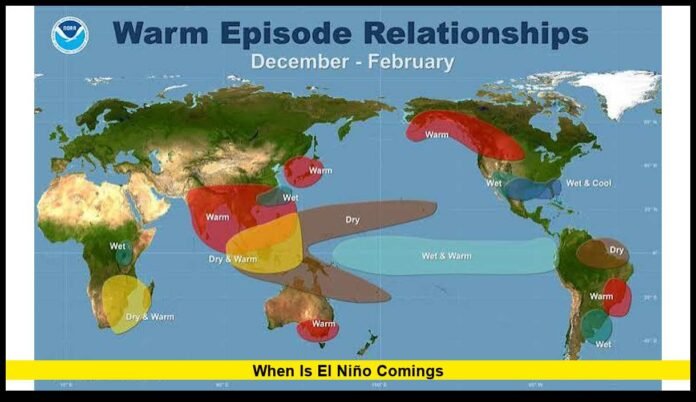

People searching when is el niño coming are now looking at a climate pattern that has moved well beyond the early development stage. As of late September 2026, El Niño is already established across the tropical Pacific and is strengthening rapidly. Current forecasts point toward an exceptionally strong event during the final months of 2026, with the effects potentially continuing into early 2027.
The developing El Niño is drawing attention because ocean temperatures across the equatorial Pacific have risen to unusually high levels. Forecast models are also showing remarkable agreement that the warming pattern will remain strong through the upcoming Northern Hemisphere fall and winter.
That does not mean every part of the United States will experience the same weather. El Niño changes the odds of certain seasonal patterns, but local temperatures, precipitation, snowfall and storms are also influenced by other atmospheric factors.
El Niño Is Already Here in 2026
The latest climate observations show that El Niño is no longer simply a possibility for later this year.
Ocean temperatures in the central and eastern equatorial Pacific have warmed substantially above average, while atmospheric indicators have developed the characteristics associated with El Niño. The combination of ocean and atmospheric changes is important because scientists do not classify an ENSO event based solely on a temporary spike in sea-surface temperatures.
The current event has strengthened considerably since the first half of 2026. By September, the warming in portions of the eastern equatorial Pacific had exceeded 3 degrees Celsius above average.
The latest climate outlooks indicate that the event is likely to intensify further before reaching its strongest phase during the colder months.
How Strong Could the 2026-27 El Niño Become?
Strength is one of the most important parts of the current forecast.
Climate agencies are describing the developing event as very strong, and the latest model guidance suggests that it could rank among the most powerful El Niño episodes in the historical record.
One of the main measurements scientists use is the Niño 3.4 index, which tracks sea-surface temperature departures across a defined region of the tropical Pacific. During mid-September, the weekly Niño 3.4 value reached roughly 3 degrees Celsius above average.
Forecast models are projecting additional warming during the fall and early winter.
The current outlook is particularly notable because the models are unusually consistent. Multiple forecasting systems are indicating that very strong El Niño conditions will continue through the peak winter period rather than weakening immediately after September.
That consistency gives forecasters greater confidence in the broad ENSO pattern, although it does not eliminate uncertainty about the precise timing or magnitude of the peak.
When Will El Niño Peak?
The strongest part of the 2026-27 El Niño is expected during late fall and winter.
Historically, El Niño events often reach maximum strength between October and February. The current event is following that general seasonal pattern, although its magnitude is much greater than what is normally observed.
The most important period to watch is therefore the final quarter of 2026 and the beginning of 2027.
Forecast models indicate that ocean temperatures could remain exceptionally elevated through October, November and December before gradually weakening during the early months of 2027.
There is no single date when scientists can say El Niño will officially “peak.” Instead, researchers evaluate three-month averages and other ocean-atmosphere measurements.
This means the peak could occur across a several-month period rather than on one particular day.
What Happens After the Peak?
Strong El Niño events generally do not remain at maximum intensity indefinitely.
Once the tropical Pacific reaches its peak warmth, changes in trade winds, ocean currents and atmospheric circulation can begin pushing the system toward weaker conditions.
The latest projections suggest that the 2026-27 El Niño should remain firmly established into early 2027. The probability of El Niño is expected to decline later in the spring as the Pacific gradually transitions toward weaker conditions.
However, the end of El Niño does not necessarily mean an immediate return to completely neutral conditions.
The atmosphere and ocean can take months to adjust after a major ENSO event, meaning that some weather patterns associated with El Niño may continue even after the ocean temperatures begin falling.
Will El Niño Continue Into 2027?
Current forecasts strongly indicate that El Niño will continue into the beginning of 2027.
The highest confidence is concentrated around the late-2026 and early-2027 winter period. Forecast confidence naturally becomes lower farther into the future, but the present model guidance supports continued El Niño conditions through much of the first part of 2027.
By spring, the event is expected to weaken substantially.
Whether the Pacific then transitions into neutral conditions or eventually develops La Niña will depend on how the ocean-atmosphere system evolves.
It is too early to treat a future La Niña as a certainty. The immediate focus remains on the exceptionally strong El Niño currently developing.
What Does El Niño Mean for the United States?
El Niño can significantly influence the position of the jet stream and the movement of storms across North America.
During many El Niño winters, the southern United States experiences an increased chance of wetter conditions. Meanwhile, parts of the northern United States can experience warmer or drier-than-average conditions.
But these are broad seasonal tendencies rather than guarantees.
An El Niño winter can still contain periods of extreme cold, heavy snow, severe storms or unusually dry weather in areas that might otherwise have a different seasonal expectation.
The strength of the current event could increase the likelihood of recognizable El Niño-related patterns, but the actual weather in individual cities will continue to depend on short-term atmospheric conditions.
California Could See Significant Winter Impacts
California is one of the states likely to receive considerable attention during the upcoming El Niño winter.
A strong El Niño can help shift Pacific storm activity toward the southern part of the United States. That can increase precipitation opportunities across California and parts of the Southwest.
For California, this could have implications for rain, mountain snow, reservoirs, rivers and flood risk.
However, more precipitation does not automatically mean every part of California will experience a wet winter.
The state’s enormous geographic range means conditions can vary considerably between Northern California, the Sierra Nevada, the Central Valley and Southern California.
The intensity and location of individual Pacific storms will also determine whether precipitation arrives as beneficial rainfall, heavy mountain snow or potentially damaging flooding.
What Could Happen Across the Southwest?
The Southwest is another region to watch closely.
El Niño frequently increases the potential for an active southern storm track. Arizona, New Mexico and parts of neighboring states can experience wetter conditions during strong El Niño winters.
For drought-affected areas, additional precipitation can provide important benefits.
At the same time, heavy precipitation occurring in a short period can create flash flooding, erosion and other hazards. Areas recently affected by wildfires can be especially vulnerable to runoff and debris flows when intense rain falls on unstable terrain.
Therefore, the potential for a wetter El Niño winter should not be interpreted as a guarantee of favorable conditions everywhere.
What About Snow?
Snowfall is one of the biggest questions surrounding the upcoming winter.
A strong El Niño can increase precipitation across portions of the southern United States and the Southwest. Where temperatures remain cold enough, that precipitation can translate into significant mountain snowfall.
The Sierra Nevada and southern Rockies could therefore receive considerable attention during the 2026-27 winter.
But El Niño does not automatically produce more snow across the entire country.
Snow depends on the interaction between moisture and temperature. A storm can produce substantial precipitation without producing much snow if temperatures remain too warm.
Elevation also plays a major role. Mountain areas can experience heavy snowfall while nearby lower elevations receive rain.
For this reason, seasonal El Niño forecasts are best used to understand broad probabilities rather than predict individual snowstorms months in advance.
What Could Happen in the Pacific Northwest?
The Pacific Northwest may experience a different pattern from parts of California and the Southwest.
Traditional El Niño patterns often favor a more southerly Pacific storm track, which can reduce precipitation opportunities in portions of the Pacific Northwest.
However, the actual 2026-27 winter pattern will depend on the precise position of the jet stream and other large-scale atmospheric features.
A seasonal El Niño signal should therefore not be interpreted as a guarantee of drought or dry weather for a particular city.
Individual storms can still bring substantial rain and mountain snow even during a broader El Niño pattern.
Could El Niño Affect Temperatures?
Yes.
El Niño can influence winter temperatures across large parts of North America by altering the jet stream and the distribution of cold and warm air.
The current seasonal outlook indicates elevated chances of above-average temperatures in several regions of the United States during parts of the upcoming fall and winter.
However, warmer seasonal averages do not eliminate the possibility of short-lived Arctic outbreaks.
A region can experience several days of very cold weather and still finish an entire season warmer than average.
This distinction is particularly important when reading long-range forecasts.
What About the Atlantic Hurricane Season?
El Niño can also affect tropical cyclone activity.
One of its best-known effects is increased vertical wind shear across portions of the Atlantic basin. Strong wind shear can make it harder for tropical systems to organize and strengthen.
That can suppress Atlantic hurricane activity under many El Niño patterns.
The Pacific can experience a different response, with El Niño often providing more favorable conditions for tropical cyclone development in parts of the eastern and central Pacific.
Nevertheless, hurricane activity is controlled by numerous variables, including ocean temperatures, atmospheric moisture, wind shear and regional circulation patterns.
El Niño is therefore an important factor but not the only one.
Why Is This El Niño Considered Unusual?
The magnitude and speed of the warming are major reasons the event is attracting attention.
The tropical Pacific has warmed rapidly, and measurements in the eastern equatorial region have reached exceptionally high levels.
The model consensus is also notable.
Forecast systems are broadly pointing toward very strong conditions during the fall and winter, with some projections indicating that the event could approach or exceed levels associated with historically significant El Niño episodes.
Even so, comparisons with past events require care because scientists have changed some measurement techniques over time.
Different ENSO indices can also produce somewhat different estimates of event strength.
As a result, determining whether an event ultimately becomes the strongest on record requires observations collected over the entire event rather than relying solely on forecasts.
Could El Niño Cause Extreme Weather?
El Niño can raise the risk of certain types of extreme weather by shifting atmospheric circulation.
Depending on location, the event can contribute to heavy rainfall, flooding, drought, heat, unusual snowfall or changes in tropical cyclone activity.
The effects are not uniform around the world.
Some regions may become wetter while others become drier. Some may experience warmer conditions while others see increased storm activity.
The strongest impacts can occur when El Niño interacts with other climate patterns.
This is why meteorologists continue monitoring the Pacific as well as atmospheric pressure, jet-stream behavior and ocean temperatures in other parts of the world.
What Should Americans Watch This Fall?
The next few months will be especially important.
Forecasters will continue tracking the Niño 3.4 index, subsurface Pacific temperatures, trade winds and atmospheric pressure patterns.
Seasonal forecasts will also become more useful as winter approaches because they can provide additional regional information about precipitation and temperature probabilities.
Residents should pay particular attention to forecasts issued by national and regional weather agencies rather than relying on generalized El Niño headlines.
People living in areas vulnerable to flooding, wildfire-related runoff, heavy snow or drought can use seasonal information as part of broader preparation, while recognizing that seasonal forecasts cannot predict individual storms months in advance.
So, When Is El Niño Coming?
For anyone still asking when is el niño coming, the important update is that the event has already arrived and is intensifying.
The biggest changes are expected during the remainder of 2026, when the tropical Pacific is forecast to reach exceptionally warm conditions. The event is then expected to remain strong through the winter before gradually weakening during 2027.
The upcoming months could become particularly important because the combination of unusually warm Pacific waters and strong atmospheric signals is creating a powerful ENSO pattern.
For the United States, the most significant effects are likely to involve seasonal precipitation, temperature, storm-track and snowfall patterns.
But El Niño should not be viewed as a simple nationwide weather forecast. Its influence varies substantially from one region to another, and short-term weather events can differ from the broader seasonal tendency.
The latest outlook therefore points to an unusually important El Niño winter ahead, with forecasters closely watching how strong the event becomes and how quickly it changes after its expected winter peak.
Key Points Summary
╔════════════════════════════════════════════════════════════════════╗
║ – El Niño is already established across the tropical Pacific as of September 2026. ║
║ – Ocean temperatures have risen to exceptionally high levels, with the event continuing to strengthen. ║
║ – Forecast models indicate that the strongest phase is likely during late fall and winter 2026-27. ║
║ – The event is expected to remain strong into early 2027 before gradually weakening. ║
║ – El Niño can influence U.S. temperatures, rainfall, snowfall and storm tracks, but its effects vary by region. ║
╚════════════════════════════════════════════════════════════════════╝