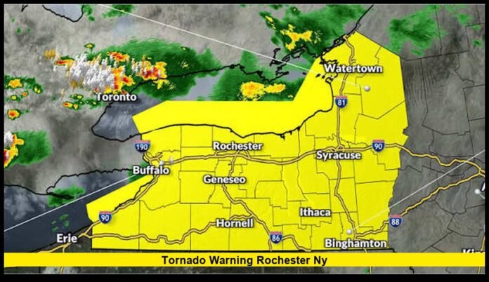

The tornado warning rochester ny alert that drew attention Wednesday evening has expired, but the severe weather left a significant mark across the Rochester region. A radar-confirmed tornado moved through the Byron area while parts of Monroe and Genesee counties remained under a tornado warning.
The warning was issued during a fast-moving evening storm on September 2. The National Weather Service identified a confirmed tornado near Byron at about 7:11 p.m. The storm was moving southeast at roughly 30 mph.
For Rochester residents checking the latest status Thursday, there is no active tornado warning from Wednesday’s event. The broader tornado watch also expired at 11 p.m. Wednesday.
The latest forecast calls for a much quieter weather pattern across Rochester today, although some showers remain possible. The temperature is expected to reach around 80 degrees.
What Happened During Wednesday’s Severe Weather
Wednesday brought several rounds of thunderstorms to Rochester and surrounding parts of western New York.
The setup created an elevated risk for damaging winds, hail, heavy rainfall and tornadoes. Storm activity developed in waves rather than from a single storm moving through the area.
The first round affected western New York during the morning. Later storms became more concerning as atmospheric conditions became more favorable for severe weather.
By Wednesday afternoon, a tornado watch covered Monroe County and numerous other counties across western and central New York. The watch remained active through 11 p.m.
Rochester was among the communities included in the watch area.
That watch meant conditions could support tornado development. Residents were urged to monitor weather alerts as storms moved through the region.
The situation became more serious during the evening when a storm produced a confirmed tornado near Byron.
Confirmed Tornado Near Byron
The most significant development occurred shortly after 7 p.m.
The National Weather Service reported that a confirmed tornado was located over Byron at 7:11 p.m. The location was about seven miles northeast of Batavia.
Radar confirmed the tornado.
The storm was moving southeast at approximately 30 mph. Officials classified the immediate threat as a damaging tornado.
The warning covered eastern Genesee County and southwestern Monroe County.
Communities listed in the warning included Batavia, Le Roy, Byron, Churchville, Riga, Stafford, Bergen, Elba, East Bethany and Mumford.
A portion of Interstate 90 between exits 47 and 48 was also included.
The warning remained in effect until 7:30 p.m.
Residents in the affected area were told to take shelter immediately. Officials urged people to move into basements or interior rooms on the lowest floor of sturdy buildings.
The warning also emphasized that heavy rain could make the tornado difficult to see.
That detail was particularly important because people should never wait until they visually spot a tornado before taking shelter.
Was Rochester Directly Under the Tornado Warning?
The answer depends on the specific location.
Rochester was included in the larger tornado watch issued Wednesday afternoon. However, the evening tornado warning focused on southwestern Monroe County and eastern Genesee County.
The confirmed tornado was near Byron.
That means it would be inaccurate to describe the event as a confirmed tornado striking the entire city of Rochester.
Parts of Monroe County were inside the warning area. The warning also covered several communities west and southwest of Rochester.
Weather alerts often cover areas larger than the exact location of the most dangerous weather. A warning identifies a zone where residents face an immediate threat based on radar information or observations.
For people searching for updates after seeing reports about Rochester, this geographic distinction matters.
The city can appear in regional weather alerts even when the strongest part of the storm is outside the city limits.
Why Wednesday’s Storms Became Dangerous
Several atmospheric factors contributed to the severe weather threat.
The region was positioned near a boundary between warmer, humid air and cooler air farther northeast. That setup helped create an environment capable of supporting thunderstorms.
Forecasters expected multiple rounds of storms throughout the day.
The later round carried a greater concern because storms could interact with stronger winds higher in the atmosphere.
That combination can help thunderstorms become organized and potentially produce damaging wind, hail or tornadoes.
The weather pattern also created a heavy rainfall concern.
Repeated thunderstorms can drop substantial amounts of rain over the same location. That increases the potential for flooding, especially when the ground has already received significant rainfall.
As storms moved across the region, officials continued to update warnings based on radar observations.
Earlier Severe Thunderstorms Hit the Rochester Region
The evening tornado was not the first severe weather threat Rochester experienced Wednesday.
An earlier line of thunderstorms moved through the region during the morning.
The storm system produced strong winds and hail. A severe thunderstorm warning included Rochester, Irondequoit, East Rochester, Webster, Fairport, Brighton and Penfield.
Wind gusts reached about 60 mph in the affected storm.
Penny-sized hail was also reported with the severe weather.
The National Weather Service warned that storms could intensify quickly and that tornadoes were possible.
That early warning was significant because it showed how unstable the weather pattern remained throughout the day.
Residents were dealing with repeated storm threats rather than a single isolated thunderstorm.
Tornado Watch Versus Tornado Warning
Understanding the difference between a watch and a warning is essential during severe weather.
A tornado watch means atmospheric conditions are favorable for tornadoes. It does not mean a tornado is currently occurring at every location inside the watch area.
A tornado warning is more urgent.
A warning means a tornado has been detected or indicated by radar, or that credible information shows a tornado threat in a particular area.
Wednesday included both types of alerts.
The broader watch covered Rochester and surrounding counties. Later, the National Weather Service issued a more specific tornado warning for parts of Monroe and Genesee counties.
Once a tornado warning is issued for a person’s location, residents should act immediately.
Waiting for additional confirmation can waste valuable time.
Communities Included in the Evening Warning
The warning area covered several communities west and southwest of Rochester.
Those locations included:
- Batavia
- Le Roy
- Byron
- Churchville
- Riga
- Stafford
- Bergen
- Elba
- East Bethany
- Mumford
The warning also covered part of Interstate 90.
The storm’s southeastward movement meant that the threat shifted quickly across the region.
Residents along the storm’s path needed to remain alert until the warning expired or officials issued an updated statement.
The National Weather Service warned that flying debris could become dangerous. Officials also warned about damage to roofs, windows, vehicles and trees.
Mobile homes faced an especially serious risk during the tornado.
Heavy Rain Made the Tornado Harder to See
One of the most important details from Wednesday’s warning involved visibility.
Heavy rainfall can obscure a tornado.
A person may not see the funnel even when a tornado is nearby.
That is why emergency officials advised residents not to wait for visual confirmation.
Weather radar can detect rotation and help forecasters identify dangerous storms before residents can see anything from the ground.
In some situations, rain-wrapped tornadoes can become particularly difficult to identify visually.
The safest response is to follow the warning immediately rather than trying to determine whether a tornado is visible outside.
What Happened After the Tornado Warning Expired
The tornado warning ended after the dangerous storm moved through the affected area.
At the time of the warning’s expiration, the storm had weakened below the level needed to maintain the tornado warning.
However, additional thunderstorms remained possible for several hours.
The larger tornado watch continued until 11 p.m. Wednesday.
That meant residents still needed to watch for additional warnings even after the specific tornado warning ended.
The end of one warning does not automatically mean that all severe weather has stopped.
Instead, each warning applies to a particular storm and geographic area.
By late Wednesday night, the severe weather threat gradually moved away from Rochester.
Current Rochester Weather After the Storms
Thursday’s forecast represents a major change from Wednesday’s active weather pattern.
Rochester can expect partly sunny conditions with a chance of showers.
The high temperature is expected to reach around 80 degrees.
Winds should remain relatively light from the west.
A small chance of showers continues into Thursday evening, but the forecast does not carry forward Wednesday night’s tornado watch.
Friday is expected to become mostly sunny after some early clouds. Temperatures should remain cooler, with a high in the mid-70s.
The weekend forecast is also much calmer.
Saturday and Sunday are expected to feature mostly sunny conditions with highs near 70 degrees.
This represents a sharp contrast with Wednesday’s combination of thunderstorms, strong winds, heavy rain and tornado concerns.
What Residents Should Do During a Future Warning
Wednesday’s weather offers an important reminder about the need for a shelter plan.
When a tornado warning affects your location, move inside immediately.
The safest option is a basement when one is available. Otherwise, use a small interior room on the lowest floor of a sturdy building.
Stay away from windows.
If you are outside, move into a substantial building as quickly as possible.
People in mobile homes face increased risk during tornadoes and should move to a sturdier shelter when a warning is issued.
Drivers should also avoid remaining on the road during a tornado warning whenever a safe substantial shelter is available.
Flying debris can cause serious injuries even when a vehicle is not directly struck by the tornado.
Why Weather Alerts Can Change Quickly
Severe thunderstorms can evolve within minutes.
A storm that initially produces heavy rain may strengthen and begin producing damaging winds. Radar may then show rotation that raises the tornado threat.
That progression can lead to a severe thunderstorm warning being replaced or supplemented by a tornado warning.
Wednesday demonstrated that progression across western New York.
The larger watch provided advance notice that the atmosphere could support tornado development. Later warnings identified specific storms and locations where the danger became immediate.
For Rochester residents, this is why checking only the morning forecast is not enough during an active severe weather day.
Conditions can change throughout the afternoon and evening.
The Importance of Checking the Exact Location
Weather alerts should always be interpreted based on location.
A tornado warning for southwestern Monroe County does not necessarily mean that every part of Rochester faces the same immediate threat.
At the same time, residents should not dismiss an alert simply because the storm is not directly overhead.
Storms move.
A warning area can shift as forecasters track the storm’s latest movement.
The most useful information includes the warning’s location, expiration time and direction of travel.
Residents should also pay attention to emergency notifications rather than relying on old screenshots or social media posts.
Outdated alerts can continue circulating after a warning has expired.
What the Latest Update Means for Rochester
The key update is straightforward: Wednesday’s tornado alerts have ended.
The confirmed tornado occurred near Byron, while the warning included southwestern Monroe County and eastern Genesee County.
Rochester was included in the broader tornado watch but was not identified as the location of the confirmed tornado.
The watch ended at 11 p.m. Wednesday.
Thursday’s forecast is significantly calmer, with partly sunny skies and only a chance of showers.
There is no current verified tornado warning carried over from Wednesday’s event.
That distinction is important for anyone seeing posts or searches that still reference the previous alert.
The presence of an old weather warning online does not mean that the warning remains active.
Looking Ahead After Wednesday’s Severe Weather
The latest forecast points toward improving conditions across Rochester after the storm system moves away.
Temperatures will gradually become more comfortable through the weekend.
The immediate concern from Wednesday’s tornado-producing storms has passed.
Still, the event serves as a reminder of how quickly severe weather can develop across western New York.
Rochester residents may experience many ordinary thunderstorms without seeing a tornado. But when forecasters identify a favorable environment, residents should take watches seriously and respond immediately to warnings.
The most important step is having a shelter location identified before severe weather arrives.
That preparation becomes especially valuable when storms develop after dark or visibility becomes poor because of heavy rainfall.
Final Update
The severe weather that generated widespread attention across the Rochester area on Wednesday has ended. The confirmed tornado near Byron was the most significant development, while portions of Monroe County were included in the associated warning.
Rochester itself was part of the broader tornado watch, but the confirmed tornado was reported near Byron rather than in the city.
Thursday brings a substantially quieter forecast, with partly sunny skies, a chance of showers and a high around 80 degrees.
Residents should continue using current official weather alerts for any new developments instead of relying on expired warnings or older reports.
Did you experience Wednesday’s storms in the Rochester area? Share what you saw and stay alert for the latest weather updates.