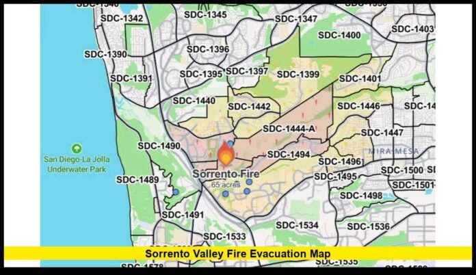

The sorrento valley fire evacuation map is drawing renewed attention after a vegetation fire was reported in the Sorrento Valley area on August 16, 2026, with smoke visible across parts of San Diego County. Residents are checking official evacuation maps for current boundaries, but the latest publicly indexed official emergency pages do not yet provide a verified zone-by-zone evacuation list for the new August incident. The safest source for a current address-level status remains the Genasys Protect emergency map.
The renewed fire activity comes only about two months after the June Sorrento Fire. That earlier blaze reached 90 acres before officials lifted all evacuation orders and contained the fire. The current August incident should not be confused with that June fire, even though reports place the newer fire in the same broader Sorrento Valley area.
What Is the Latest Sorrento Valley Fire Evacuation Map Status?
The most important point for residents is that evacuation boundaries can change quickly during a wildfire. Genasys Protect allows people to enter an address or zone number and see the status associated with that location. San Diego County identifies Genasys Protect as the public-facing evacuation application used for current emergency mapping.
As of the latest verifiable information available for this article, a current official zone list for the August 16 Sorrento Valley fire could not be independently confirmed through the publicly indexed Alert San Diego and CAL FIRE pages.
That distinction matters. Social media posts and community discussions have reported changing fire conditions and possible evacuation activity, but those reports do not provide enough official confirmation to publish a specific current evacuation-zone list as fact.
Residents should therefore use the live Genasys map rather than relying on an older screenshot or a social media map.
Where to Check the Official Evacuation Map
Genasys Protect provides an interactive map where users can search by address or evacuation-zone identification. The system is designed to show whether an area has an evacuation order, warning, lifted order or another emergency status.
San Diego County also maintains evacuation planning resources and identifies Genasys Protect as its public application for evacuation information. The county’s emergency management resources include digital evacuation maps and zone information.
For someone trying to determine whether a particular home, workplace or other property is affected, checking the exact address is more reliable than judging the situation by distance from the fire.
Why the Map Is More Important Than a General Fire Location
A wildfire does not affect every property around its perimeter in the same way. Evacuation officials divide communities into geographic zones so they can issue targeted orders and warnings.
The map can therefore show a different status for neighboring areas.
An Evacuation Order means authorities have determined that there is an immediate threat and people in the affected area must leave. An Evacuation Warning indicates a potential threat and tells residents to prepare for possible evacuation.
CAL FIRE’s evacuation map guidance uses the same basic distinctions. An order means an immediate threat to life, while a warning indicates a potential threat to life or property.
This is why residents should not assume they are safe simply because their immediate neighborhood is outside a visible smoke plume.
What Happened During the June Sorrento Fire?
The June Sorrento Fire provides important context for understanding why residents are closely watching the current map.
That fire began near Sorrento Valley Boulevard and Ocean Air Drive on June 8, 2026. CAL FIRE recorded the incident in San Diego County and reported that it eventually reached 90 acres. The fire was fully contained on June 10.
The June incident generated several evacuation orders and warnings as the fire expanded. At one stage, official evacuation orders covered zones including SDC-1443, SDC-1444-A, SDC-1444-B, SDC-1492-A, SDC-1492-B and SDC-1494. Additional surrounding zones were placed under warnings.
The boundaries changed as firefighters gained control.
That experience demonstrates why residents should not use June’s evacuation map as the map for the August fire. A zone that was affected in June may have a different status during another incident.
The June Evacuation Orders Were Eventually Lifted
The June fire’s evacuation situation changed rapidly during the final stages of the response.
Alert San Diego reported that all evacuations had been lifted on June 8 after officials determined that conditions had improved. The temporary evacuation point at 4275 East Gate Mall was closed after the evacuations ended.
CAL FIRE later recorded the June fire as 100% contained.
The final incident record shows the fire remained at 90 acres and was contained on June 10 at 9 p.m.
Those facts are useful when searching for the Sorrento Valley fire evacuation map online because many older results still refer to the June incident.
Why Older Sorrento Valley Maps Can Be Misleading
Search results can continue displaying evacuation maps long after an incident has ended.
For example, an archived Genasys page for zone SDC-1492-A records that the evacuation order was lifted during the June fire. The page also identifies the boundaries of that specific zone.
That information is historical. It does not establish the status of the same zone during a later fire.
This is particularly important during a fast-moving incident. A screenshot saved several hours earlier can become inaccurate after officials change an order, expand a warning or begin repopulating an area.
For that reason, residents should refresh the official map before making decisions based on evacuation boundaries.
What the Sorrento Valley Fire Evacuation Map Can Tell Residents
The map is useful for more than determining whether an address is currently under an order.
Residents can use it to identify the status of nearby zones and understand how emergency boundaries are developing. The system also provides information related to evacuation areas and road closures. Alert San Diego directs residents to Genasys Protect for updated emergency evacuation information.
Important information to check includes:
- Whether the property is under an evacuation order
- Whether the property is under an evacuation warning
- Whether an earlier order has been lifted
- Whether nearby zones have changed status
- Whether roads near the affected area remain closed
- Whether emergency officials have issued additional instructions
Checking the map directly is especially important for residents who live near Sorrento Valley, Mira Mesa, Rancho Peñasquitos, Carmel Valley or nearby open-space areas.
Do Not Rely on Smoke Direction to Determine Evacuation Status
Smoke can travel well beyond the immediate fire area. Community reports on August 16 and August 17 described smoke and haze in areas well away from the reported fire location.
Those observations can help explain why people are seeing smoke, but they do not establish evacuation boundaries.
A neighborhood may experience heavy smoke without being under an evacuation order. Conversely, an area can be subject to an evacuation warning before flames or dense smoke become visible.
The evacuation map and official emergency notifications remain the appropriate tools for determining whether an address is affected.
What Residents Should Do If Their Zone Changes
If an official evacuation order applies to an address, residents should leave immediately and follow directions from emergency personnel.
People who receive an evacuation warning should prepare to leave quickly if the situation worsens. That includes gathering essential belongings, medications, important documents and items needed for pets.
Residents should also avoid entering closed areas simply to inspect the fire or take photographs. Active wildfire areas can contain fire crews, emergency equipment, unstable vegetation and other hazards.
The official emergency map should be checked again after any major fire behavior change or emergency notification.
Sorrento Valley Fire Evacuation Map and the Difference Between Current and Historical Information
The biggest challenge for people searching online is separating the current August 2026 incident from the June Sorrento Fire.
The June incident has a well-documented official record. It reached 90 acres, generated multiple evacuation zones and was ultimately contained.
The August incident is newer, and publicly indexed official records available at the time of writing do not yet provide a complete, independently verifiable zone list for the new fire.
That means publishing the June evacuation zones as if they are current would be inaccurate.
The correct approach is to use the live Genasys Protect map for the latest address-specific status and treat older Sorrento Fire maps as historical references.
How to Check Your Address on the Map
Genasys Protect provides an address-search function on its public emergency map. Users can enter their location and review the status associated with the applicable evacuation zone.
Residents should check the map directly rather than relying solely on search-engine snippets, screenshots or community posts.
San Diego County’s emergency management information also points residents toward Genasys Protect for public evacuation information.
The same approach is useful for homes, businesses and other locations. If a person has more than one important location, each address should be checked separately because evacuation boundaries are geographic.
Bottom Line on the Sorrento Valley Fire Evacuation Map
The latest information shows why residents should be cautious when searching for a sorrento valley fire evacuation map. A new fire was reported in the area on August 16, while the best-documented Sorrento Fire from June had already been fully contained and its evacuation orders lifted.
For the August incident, a complete current evacuation-zone list could not be independently verified from the publicly indexed official sources reviewed for this article. Publishing older June zones as current would risk giving residents incorrect information.
The most reliable method is to search the affected address directly through Genasys Protect and follow any current order, warning or emergency instruction issued by San Diego authorities.
If you are watching the Sorrento Valley fire, check your exact evacuation zone and share any confirmed updates in the comments so others can stay informed.