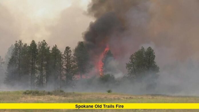

The Old Trails Fire Spokane residents are now closely watching erupted on Saturday, August 1, 2026, near Old Trails Road and West Euclid Road in the West Plains area northeast of Airway Heights, Washington. Fueled by a Particularly Dangerous Situation Red Flag Warning, ferocious winds, and bone-dry vegetation, the blaze exploded from a small brush fire into a several-thousand-acre emergency in a matter of hours, prompting Level 3 “Go Now” evacuation orders across large portions of Spokane County and the city of Spokane itself.
How the Fire Started and Spread
According to Washington State Fire Marshal officials, the fire ignited around 11:56 a.m. on August 1, 2026, in the vicinity of Old Trails Road and Euclid Road, an area just northeast of Airway Heights. Within about ninety minutes, the fire had already burned an estimated 350 to 400 acres, according to tracking from the Watch Duty wildfire monitoring service. The cause of the fire remains under investigation, and officials have not released an official determination as of this writing.
What began as a fast-moving grass and brush fire quickly turned into a life-threatening event. Sustained wind gusts of 35 to 50 miles per hour, combined with low humidity and drought conditions across Eastern Washington, allowed the fire to make repeated crown runs through timber and quickly outpace initial containment efforts. By early afternoon, the fire had grown to roughly 500 acres, and within a few more hours it had ballooned to approximately 2,000 to 2,500 acres, based on updates from WildCAD and local fire agencies.
The fire’s most alarming development came when it jumped the Spokane River and pushed directly into the Indian Trail neighborhood on the northwest side of the city of Spokane. This is a rare and dangerous occurrence, since the river typically acts as a natural firebreak. Longtime residents described conditions they had never witnessed before, with flames and heavy smoke visible near homes, churches, and community facilities well inside city limits.
Evacuations and Emergency Response
As the fire spread, Spokane County Emergency Management issued a series of expanding Level 3 evacuation orders, the highest level used in Washington State, meaning residents must leave immediately due to life-threatening conditions. Evacuation zones initially covered areas between Newkirk Road and Trails Road, and Westwood Lane and Dowdy Road, before expanding further north to Rutter Parkway and east across the Spokane River into the city, eventually reaching North Division Street between West Francis Avenue and West Price Avenue.
Riverside State Park and the Dwight Merkel Sports Complex were both placed under immediate evacuation orders as the fire moved through the park and toward nearby neighborhoods. The Mann-Grandstaff VA Medical Center also began evacuating patients and staff as a precaution. An evacuation shelter was opened at Spokane Falls Community College, located at 3410 West Whistalks Way, while an animal shelter for displaced pets and livestock was set up at the Spokane County Fairgrounds.
Emergency crews reported that homes along West Euclid Road were destroyed as the fire tore through the area, and some residents were seen fleeing with pets that had suffered burn injuries. Firefighting resources on scene included multiple fixed-wing air tankers and at least one helicopter, along with ground crews from several local and state agencies. Washington State Patrol Chief John Batiste authorized the mobilization of state firefighting resources at 1:30 p.m., deploying five strike teams to reinforce local departments.
Utility provider Avista shut off power to more than 7,000 customers in the affected area as a Public Safety Power Shutoff, a precautionary measure taken ahead of the fire’s arrival in some neighborhoods. The company later confirmed that additional outages resulted directly from the fire burning into its infrastructure, separate from the planned shutoffs.
Statewide Emergency Declaration
Given the scale and speed of the Old Trails Fire, along with several other blazes burning simultaneously across the state, Washington Governor Bob Ferguson declared a state of emergency on August 1, 2026. The proclamation activated the Washington National Guard to assist with the response, marking the first time the Guard has been called up for a wildfire in Washington since 2021. The governor also imposed a statewide burn ban that will remain in effect through September 30, 2026, and authorized the state to draw on additional resources through the Emergency Management Assistance Compact.
The National Weather Service had warned in advance that Central and Eastern Washington faced a Particularly Dangerous Situation Red Flag Warning from 11 a.m. to 9 p.m. on August 1, a designation reserved for the most extreme fire weather conditions. Officials pointed to a combination of record-setting drought, low relative humidity, and an approaching cold front as the primary drivers behind the explosive fire behavior seen across the region that afternoon.
State officials noted that the Old Trails Fire is one of roughly a dozen large wildfires currently burning across Washington, which together have consumed more than 200,000 acres statewide. Even so, national wildfire data indicates that total acreage burned across the United States in 2026 remains well below the twenty-year average, underscoring how localized and severe this particular outbreak of fire activity has been for the Spokane region.
Public Reaction and Community Impact
The rapid advance of the fire into residential neighborhoods left many Spokane-area residents shaken. Longtime locals described the fire’s approach toward the heart of the city as unlike anything they had experienced in three decades of living in the area. Families scrambled to gather belongings, secure pets, and check on relatives as evacuation orders expanded street by street throughout the afternoon and evening.
Local news outlets and emergency responders continued to urge residents in and near the evacuation zones to avoid North Division Street and North 291 Francis Avenue except when actively evacuating, in order to keep roadways clear for fire apparatus and outbound traffic. Spokane County Emergency Management also directed residents to monitor the county’s official evacuation mapping tool for the most current boundary information, as conditions were changing rapidly throughout the day.
Community members quickly organized informal support efforts, including offers of temporary housing, transportation, and supplies for displaced neighbors. Local shelters reported a steady stream of evacuees, and county officials worked to coordinate resources for both people and animals affected by the fast-moving disaster.
Latest Updates
As of the most recent reports, the Old Trails Fire remains active with containment not yet established. Fire officials have not released a specific containment percentage, and the fire’s final size may continue to change as crews work through the night and into Sunday to slow its advance. Authorities have not confirmed any fatalities, though the extent of property damage, including the number of homes lost along West Euclid Road and in the Indian Trail area, is still being assessed.
Because this remains a developing situation, residents in the Spokane area are advised to rely on official channels, including Spokane County Emergency Management and local fire agencies, for the latest evacuation levels and safety guidance rather than secondhand reports on social media. Air quality in the region may also be affected by heavy smoke, and officials have not yet issued a formal timeline for when evacuated residents might be allowed to return home.
Final Thoughts
The Old Trails Fire has become one of the most significant wildfire emergencies to threaten the city of Spokane in recent memory, combining extreme wind-driven fire behavior with a direct push into residential neighborhoods that many assumed were shielded by the Spokane River. The rapid escalation from a few hundred acres to thousands of acres within hours illustrates how quickly fire conditions can shift when drought, low humidity, and high winds converge.
With a statewide state of emergency in place, National Guard resources activated, and firefighting crews from across Washington working to gain the upper hand, officials are focused on protecting lives and property while the fire remains active. Residents in and around Spokane County are encouraged to stay alert, follow evacuation orders promptly, and check official sources regularly as this wildfire situation continues to unfold.
Stay tuned for further updates on the Old Trails Fire and share your thoughts or local observations in the comments below.