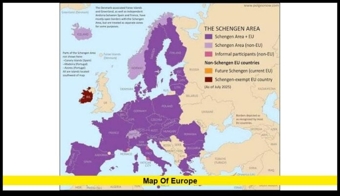

The map of Europe remains one of the most searched geography topics in 2026 as travelers, students, businesses, and researchers seek the latest information about European countries, political boundaries, the European Union, the Schengen Area, and major geographic features. Modern maps now reflect current administrative and economic developments, making an updated understanding of Europe more valuable than ever.
What Is the Map of Europe?
A map of Europe is a geographic representation of the continent that displays countries, capitals, borders, major cities, rivers, mountain ranges, and surrounding seas. Depending on its purpose, a map may also highlight transportation networks, physical landforms, climate zones, or political divisions.
Europe covers approximately 10.2 million square kilometers and is the world’s second-smallest continent by land area. Despite its size, it is home to dozens of sovereign nations and hundreds of millions of residents.
How Many Countries Are in Europe?
One of the most common questions is how many countries Europe has.
Most modern political maps recognize 44 countries located entirely within Europe, while several nations are considered transcontinental because they extend into both Europe and Asia.
These include:
- Russia
- Türkiye
- Kazakhstan
- Georgia
- Azerbaijan
Some educational maps also display Kosovo separately, although international recognition differs among countries.
Because geographic definitions vary slightly, different atlases may list different totals while remaining factually accurate.
Europe’s Five Main Geographic Regions
Geographers commonly divide Europe into five major regions.
Northern Europe
Northern Europe includes:
- Norway
- Sweden
- Finland
- Denmark
- Iceland
This region is known for spectacular fjords, Arctic landscapes, forests, and strong renewable energy production.
Western Europe
Western Europe generally includes:
- France
- Germany
- Belgium
- Netherlands
- Luxembourg
- Austria
- Switzerland
Many of Europe’s largest financial centers and manufacturing industries are located here.
Southern Europe
Southern Europe includes Mediterranean countries such as:
- Italy
- Spain
- Portugal
- Greece
- Croatia
- Slovenia
- Malta
This region attracts millions of tourists every year because of its beaches, historic cities, and mild climate.
Eastern Europe
Eastern Europe commonly includes:
- Poland
- Romania
- Bulgaria
- Ukraine
- Belarus
- Moldova
These countries play an important role in European transportation, agriculture, and regional trade.
Central Europe
Many modern geography references classify these nations as Central Europe:
- Czech Republic
- Slovakia
- Hungary
- Austria
- Switzerland
Their central location makes them major transportation and logistics hubs.
European Union Countries in 2026
Many people use a map of Europe to identify members of the European Union (EU).
As of 2026:
- The European Union has 27 member countries.
- Croatia remains the newest member after joining in 2013.
- The United Kingdom is not part of the European Union following Brexit.
EU membership influences trade, economic policy, and many cross-border agreements across the continent.
Schengen Area Explained
The Schengen Area is different from the European Union.
Its purpose is to allow passport-free travel between participating countries.
Current Schengen members include most EU countries along with several non-EU nations.
Recent travel policy changes mean that Romania and Bulgaria now participate fully in the Schengen Area, making cross-border travel easier throughout much of Europe.
Eurozone Update
The euro remains one of the world’s most important currencies.
As of 2026:
- Bulgaria officially adopted the euro.
- The eurozone now includes 21 countries.
- The euro continues to be the common currency for most EU members.
Economic maps now identify Bulgaria as part of the euro area.
Largest Countries in Europe
Europe contains countries of dramatically different sizes.
The largest include:
| Country | Notable Fact |
|---|---|
| Russia | Largest country spanning Europe and Asia |
| Ukraine | Largest country located entirely in Europe |
| France | Largest country in Western Europe |
| Spain | Major country on the Iberian Peninsula |
| Sweden | Largest country in Northern Europe |
Europe’s Smallest Countries
Several independent nations occupy very small areas on the map.
These include:
- Vatican City
- Monaco
- San Marino
- Liechtenstein
- Andorra
Although small in size, each maintains its own government and international identity.
Major Capitals Across Europe
Capital cities serve as political and cultural centers.
Some of Europe’s best-known capitals include:
- Paris
- Berlin
- Madrid
- Rome
- Lisbon
- Vienna
- Brussels
- Athens
- Warsaw
- Prague
- Stockholm
- Helsinki
- Dublin
Many are among the world’s most visited destinations.
Read Also – Where Is Pompeii in Italy? Exact Location, Map Breakdown, and 2026 Visitor Guide
Famous Mountain Ranges
Europe features several important mountain systems.
The Alps
Stretch across:
- France
- Switzerland
- Italy
- Austria
- Germany
- Slovenia
The Alps attract visitors year-round for skiing, hiking, and scenic tourism.
The Pyrenees
The Pyrenees form a natural border between France and Spain.
The Carpathian Mountains
These mountains extend through:
- Romania
- Slovakia
- Poland
- Ukraine
The Carpathians contain some of Europe’s largest forested regions.
The Scandinavian Mountains
These mountains dominate much of Norway and western Sweden.
The Ural Mountains
The Ural Mountains traditionally separate Europe from Asia.
Europe’s Major Rivers
Several of the world’s best-known rivers flow through Europe.
Among the largest are:
- Danube
- Rhine
- Volga
- Seine
- Thames
- Elbe
- Po
These rivers support transportation, agriculture, tourism, and commerce.
Surrounding Seas and Oceans
Europe is bordered by several important bodies of water.
These include:
- Atlantic Ocean
- Arctic Ocean
- Mediterranean Sea
- Baltic Sea
- Black Sea
- North Sea
- Norwegian Sea
These waterways have influenced European trade for centuries.
Climate Across Europe
Europe experiences a wide range of climates.
Northern Europe generally has:
- Cold winters
- Cool summers
Western Europe enjoys:
- Mild temperatures
- Ocean-influenced weather
Southern Europe is known for:
- Warm summers
- Mild winters
- Mediterranean conditions
Eastern Europe typically experiences:
- Greater seasonal temperature differences
- Continental weather patterns
Languages Spoken in Europe
Europe is one of the world’s most linguistically diverse regions.
Major languages include:
- English
- French
- German
- Spanish
- Italian
- Portuguese
- Dutch
- Polish
- Romanian
- Greek
- Swedish
- Finnish
Hundreds of regional and minority languages are also spoken throughout the continent.
Transportation Networks
Modern European maps frequently highlight transportation systems.
These include:
- High-speed rail
- International highways
- Ferry routes
- International airports
- Inland waterways
Europe’s transportation network makes travel between many countries efficient and convenient.
Popular Tourist Destinations
Europe remains one of the world’s leading travel destinations.
Popular cities include:
- Paris
- Rome
- Barcelona
- Amsterdam
- Prague
- Vienna
- Athens
- Venice
Historic landmarks, museums, beaches, and mountain scenery continue to attract visitors from around the globe.
Political Maps vs. Physical Maps
Different maps serve different purposes.
Political Maps
Political maps display:
- International borders
- Countries
- Capitals
- Administrative divisions
Physical Maps
Physical maps highlight:
- Mountains
- Rivers
- Lakes
- Plains
- Elevation
Road Maps
Road maps focus on:
- Highways
- Railways
- Major routes
- Cities
Each type helps users understand a different aspect of European geography.
Digital Maps in 2026
Digital mapping technology continues to improve.
Modern online maps provide:
- Satellite imagery
- Live navigation
- Traffic updates
- Public transportation routes
- Terrain views
- Walking and cycling directions
Frequent updates help ensure that roads, transit systems, and place names remain accurate.
Why the Map of Europe Continues to Change
While Europe’s international borders have remained largely stable in recent years, maps continue to receive updates for several reasons.
Changes may include:
- Transportation improvements
- Administrative adjustments
- Economic classifications
- Currency adoption
- Travel policy updates
- Infrastructure development
These updates make current maps more useful for travelers, businesses, educators, and researchers.
Why Learning Europe’s Geography Matters
Understanding Europe’s geography benefits more than students.
Businesses use maps to manage logistics.
Travelers use them to plan routes.
Researchers analyze demographic and environmental information.
Teachers rely on maps to explain history, politics, and economics.
An accurate map also helps readers understand current international events and regional cooperation.
Choosing the Right Europe Map
The best map depends on your purpose.
A political map works well for identifying countries and capitals.
A physical map is ideal for learning about mountains and rivers.
Road maps help travelers navigate efficiently.
Digital interactive maps provide the latest geographic updates and navigation tools.
Selecting the appropriate map ensures that the information matches your needs.
Whether you’re planning a European adventure, studying geography, or simply exploring the continent from home, share your thoughts in the comments and stay updated with the latest geography insights.