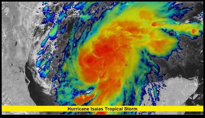

Hurricane Isaias tropical storm conditions have escalated quickly, with Isaias now a Category 1 hurricane moving toward the northern Gulf Coast and threatening parts of Louisiana, Mississippi, Alabama and Florida.
The storm strengthened into the first hurricane of the 2026 Atlantic season overnight Wednesday into Thursday. National Hurricane Center data early Thursday showed maximum sustained winds near 80 mph, with stronger gusts, while Hurricane Hunter aircraft continued gathering information inside the system.
Isaias was located in the Gulf of Mexico about 420 miles south-southwest of the mouth of the Mississippi River early Thursday. It was moving east-northeast at about 9 mph.
Forecasters expect the hurricane to strengthen further before approaching the northern Gulf Coast. The current forecast calls for landfall within the warning area late Friday or early Saturday.
The developing threat includes hurricane-force winds, dangerous storm surge, heavy rainfall, flash flooding, rough seas and isolated tornadoes. Residents along the northern Gulf Coast have been urged to finish preparations before conditions deteriorate.
Isaias Has Strengthened From a Tropical Storm Into a Hurricane
Isaias developed rapidly after forming as a tropical depression over the Gulf of Mexico on October 6. The system became Tropical Storm Isaias early Wednesday, October 7, as its organization improved over warm Gulf waters.
By Wednesday evening, the storm was nearing hurricane strength. Aircraft reconnaissance confirmed the increase in intensity, and Isaias officially became a hurricane late Wednesday night.
The transition happened quickly.
Early Thursday, NOAA Hurricane Hunter aircraft found maximum sustained winds of about 80 mph. That placed Isaias within Category 1 hurricane strength on the Saffir-Simpson Hurricane Wind Scale.
The storm also had a minimum central pressure near 979 millibars, another indication of its strengthening circulation.
The hurricane remained relatively compact, with hurricane-force winds extending roughly 15 miles from the center and tropical-storm-force winds extending as far as 90 miles.
Additional strengthening was expected through early Friday.
That means residents should not rely on earlier information that described Isaias only as a tropical storm. The storm has already crossed the hurricane threshold, and the latest official forecasts treat it as a hurricane approaching the Gulf Coast.
Where Is Hurricane Isaias Now?
As of the latest available National Hurricane Center advisory early Thursday, Isaias was located near 23.3 degrees north latitude and 91.2 degrees west longitude.
The storm was approximately:
- 420 miles south-southwest of the mouth of the Mississippi River
- 170 miles northwest of Progreso, Mexico
- Over the Gulf of Mexico
- Moving east-northeast at approximately 9 mph
- Producing maximum sustained winds near 80 mph
- Maintaining a minimum central pressure near 979 millibars
Isaias was expected to pass north of the Yucatán Peninsula before turning more toward the northeast and eventually north.
The storm’s forward movement is important because its eventual direction will determine where the strongest winds, storm surge and rainfall reach the coast.
Forecast officials continue to emphasize that residents should use official local warnings rather than relying only on the centerline of a forecast track.
When Is Isaias Expected to Reach the U.S. Coast?
The current forecast places the most significant U.S. impacts late Friday into early Saturday.
Isaias is expected to turn toward the northeast later Thursday and then move northward on Friday. The storm should approach the northern Gulf Coast as a strong hurricane.
The exact point of landfall can still change as new aircraft observations and forecast data become available.
Current forecasts place the greatest concern across the northern Gulf Coast, particularly areas near the Mississippi-Alabama border and the western Florida Panhandle.
The hurricane warning area covers a broad section of the coast because dangerous conditions can extend well away from the eventual landfall location.
Residents should also remember that the center of a hurricane does not define the entire danger zone. Storm surge, rain and tropical-storm-force winds can affect communities well outside the area where the eye crosses the coast.
Hurricane Warnings Cover Parts of the Gulf Coast
A hurricane warning is currently in effect from Ocean Springs, Mississippi, to the Bay/Gulf County line in Florida.
That includes portions of the Mississippi coast, Alabama coast and Florida Panhandle.
A tropical storm warning extends beyond the hurricane warning area. The broader warning zone includes portions of southeastern Louisiana and additional areas of Florida east of the main hurricane warning.
A storm surge warning is also in effect from the mouth of the Mississippi River eastward to the Steinhatchee River in Florida.
These warnings mean residents should not wait for the final track to become perfectly clear before taking action.
Local emergency management agencies may issue additional evacuation orders, road restrictions, shelter information or other instructions based on local conditions.
Storm Surge Could Become a Major Threat
Storm surge is one of the most serious dangers associated with Isaias.
Forecasts indicate that water could rise approximately 5 to 7 feet above ground level in parts of the Gulf Coast, particularly from coastal Mississippi across Alabama and toward the western Florida Panhandle.
The exact amount of surge at any particular location will depend on the storm’s final track, intensity, wind field, coastal shape and the timing of high tide.
Mobile Bay and nearby coastal communities are among the areas receiving close attention because water can move rapidly into low-lying locations.
Storm surge does not behave like ordinary rainfall flooding. Ocean water can push inland quickly, covering roads and entering buildings in vulnerable areas.
People living in evacuation zones should follow local instructions immediately rather than attempting to judge the danger by looking outside.
Even a modest change in Isaias’s track could shift the location of the highest surge.
Heavy Rainfall and Flash Flooding Are Expected
Rainfall will be another major component of the Isaias threat.
Forecasts call for roughly 3 to 7 inches of rain across portions of the central Gulf Coast, with isolated totals potentially reaching around 10 inches.
The heaviest rainfall may occur in bands around the hurricane and along areas where tropical moisture interacts with existing weather systems.
Flash flooding could develop quickly when intense rain falls over a short period.
Low-lying communities, poor-drainage areas and locations near rivers and streams face elevated risks.
The National Weather Service has also highlighted the potential for localized flash flooding and river flooding as Isaias moves toward and across the Gulf Coast.
Rainfall could continue after the storm center moves inland, meaning the end of the strongest winds will not necessarily mark the end of the flooding threat.
Tornado Threat Will Increase Across the Southeast
Isaias is also expected to produce isolated tornadoes.
The primary tornado threat is expected Friday night into Saturday across parts of Alabama, the Florida Panhandle and southwestern Georgia.
The risk can continue farther inland as the system moves north and northeast.
Tornadoes associated with tropical cyclones can develop quickly within rain bands. They may also be difficult to see because heavy rainfall can hide the circulation.
Residents should keep multiple ways to receive emergency warnings, especially overnight when outdoor conditions are difficult to monitor.
A hurricane does not need to be a major hurricane to produce tornadoes. Strong thunderstorms embedded within the outer bands can create dangerous localized conditions even far from the storm’s center.
How Strong Could Isaias Become?
Additional strengthening remains possible before landfall.
The National Hurricane Center reported that Isaias continued to intensify after reaching hurricane strength. Hurricane Hunter aircraft have been providing direct measurements of the storm’s internal structure, winds and pressure.
Warm Gulf waters are supporting the hurricane, while some wind shear remains present.
The combination of favorable environmental conditions and the storm’s improving organization has kept rapid strengthening as an important concern.
Forecast guidance has indicated that Isaias could become a stronger Category 2 hurricane before reaching the coast.
However, the exact peak intensity cannot be known in advance.
Hurricane strength depends on several interacting factors, including ocean temperatures, atmospheric moisture, wind shear and the structure of the storm’s inner core.
For that reason, coastal residents should prepare for the hazards associated with the current warnings rather than waiting to see whether Isaias reaches a particular category.
The Hurricane’s Development Has Been Rapid
The recent history of Isaias shows how quickly conditions have changed.
A simplified timeline is:
| Date | Isaias status |
|---|---|
| October 6 | Tropical Depression Nine formed over the Gulf |
| October 7 | Depression strengthened into Tropical Storm Isaias |
| October 7 | Hurricane watches and storm surge watches expanded |
| October 7 night | Isaias approached hurricane strength |
| October 8 | Isaias strengthened into a Category 1 hurricane |
| October 8 | Further strengthening expected |
| October 9-10 | U.S. Gulf Coast landfall expected |
This rapid progression is why earlier forecasts can look different from the latest information.
The storm went from a tropical depression to a hurricane in less than two days.
Residents following older social media posts or previous forecasts should therefore check the publication time carefully. Information from Wednesday morning may no longer accurately describe the storm Thursday.
Which States Are Most at Risk?
The strongest direct impacts are expected along portions of the northern Gulf Coast.
The areas receiving the greatest attention include:
- Louisiana’s southeastern coast
- Coastal Mississippi
- Coastal Alabama
- The western Florida Panhandle
- Parts of southwestern Georgia
- Inland areas across the Southeast
Louisiana is expected to experience tropical-storm conditions in portions of the southeastern coastal region, while the hurricane warning covers areas farther east.
Mississippi and Alabama face a particularly serious combination of wind and storm surge threats.
The western Florida Panhandle could experience some of the strongest impacts because of its location relative to the forecast path.
Farther inland, heavy rainfall and tornadoes could remain concerns after the storm moves away from the coastline.
What Residents Along the Gulf Coast Should Watch
People in areas covered by hurricane or storm surge warnings should focus on official emergency instructions.
The most important developments to monitor include:
- Changes to the hurricane warning area
- Changes to evacuation orders
- Updates to the storm’s projected landfall
- Changes in storm surge forecasts
- Wind-speed increases
- Flood watches and warnings
- Tornado watches and warnings
- Road and bridge closures
- Local shelter announcements
A storm’s category does not tell the entire story.
For example, a Category 1 hurricane can still produce life-threatening storm surge and flooding. Likewise, rainfall and tornadoes can create dangerous conditions far from the hurricane’s center.
Residents should also account for possible power outages and travel disruptions.
Why the Storm’s Track Matters So Much
The difference between a landfall in western Florida and one farther west in Alabama or Mississippi could significantly change which communities receive the strongest winds and highest surge.
The eastern side of a landfalling Gulf Coast hurricane can experience especially dangerous conditions because of the combination of storm circulation and forward movement.
Small changes in track can also shift the area of maximum rainfall.
That makes the forecast cone useful for understanding uncertainty, but it should not be treated as a boundary around all possible impacts.
Hazardous weather can occur outside the cone.
The National Hurricane Center and local National Weather Service offices will continue updating forecasts as new observations arrive.
Isaias Is the First Atlantic Hurricane of 2026
Isaias has also become notable because it is the first hurricane of the 2026 Atlantic season.
The Atlantic had experienced an unusually long period without a hurricane before Isaias strengthened.
According to the National Hurricane Center’s 2026 Atlantic season summary, nine named storms had been recorded through October 8, but only one had reached hurricane strength.
Isaias is therefore an important change in the season’s overall activity.
The storm’s development also demonstrates why hurricane preparedness remains important even during periods of relatively low Atlantic activity.
Hurricane season officially runs through November 30, and late-season systems can still develop under favorable conditions.
What Happens After Isaias Makes Landfall?
The hurricane is expected to weaken after moving inland, but its hazards will not disappear immediately.
Heavy rainfall could continue across parts of the Southeast.
The system may also bring strong winds and isolated tornadoes farther inland as it moves northward.
Flooding can become a longer-lasting problem, particularly where rainfall accumulates faster than rivers and drainage systems can handle it.
Coastal areas may also experience lingering dangerous surf and rip currents after the center passes.
Residents should therefore avoid assuming that conditions become safe immediately after the hurricane moves inland.
Local authorities may keep warnings active until specific threats have passed.
Why the Term “Tropical Storm Isaias” Still Appears in Searches
Many people searching for “Hurricane Isaias tropical storm” are seeing a mixture of older and newer storm information.
That is because Isaias was officially a tropical storm before strengthening into a hurricane.
The storm became Tropical Storm Isaias on October 7. Less than two days later, it reached hurricane strength.
As a result, reports, weather posts and search results published at different times may use different classifications.
The most important distinction is the timing of the information.
As of the latest verified update available Thursday, October 8, Isaias is a Category 1 hurricane, not merely a tropical storm.
The storm is continuing to strengthen while moving toward the northern Gulf Coast.
Frequently Asked Questions
Is Isaias still a tropical storm?
No. Isaias strengthened into a Category 1 hurricane late Wednesday night and had maximum sustained winds near 80 mph in the latest early Thursday National Hurricane Center advisory.
Where is Hurricane Isaias now?
Isaias is over the Gulf of Mexico, approximately 420 miles south-southwest of the mouth of the Mississippi River based on the latest early Thursday advisory.
When will Hurricane Isaias make landfall?
The latest forecast calls for Isaias to reach the northern Gulf Coast late Friday or early Saturday.
Which states are most threatened by Isaias?
The greatest concerns are along parts of Louisiana, Mississippi, Alabama and the Florida Panhandle, with additional rainfall and tornado threats extending inland.
How much storm surge is expected from Isaias?
Forecasts indicate storm surge of approximately 5 to 7 feet in the most vulnerable portions of the Mississippi coast, Alabama coast and western Florida Panhandle.
How much rain could Isaias produce?
Forecast rainfall totals of about 3 to 7 inches are expected across parts of the central Gulf Coast, with isolated amounts potentially approaching 10 inches.
Could Isaias produce tornadoes?
Yes. Isolated tornadoes are possible Friday night across coastal Alabama, the Florida Panhandle and southwestern Georgia, with the threat continuing Saturday across parts of the Southeast.
Could Isaias strengthen before landfall?
Yes. The National Hurricane Center expects additional strengthening before the hurricane reaches the northern Gulf Coast.
Is Isaias the first hurricane of 2026?
Yes. Isaias became the first hurricane of the 2026 Atlantic season after strengthening over the Gulf of Mexico.
Why are earlier reports calling Isaias a tropical storm?
Isaias previously had tropical-storm status. It strengthened into a hurricane overnight Wednesday, so older reports may still describe the system as a tropical storm.
Hurricane Isaias remains an evolving Gulf Coast threat, and the storm’s strength, track and hazards can change as new aircraft observations and forecasts become available.
Stay alert to the latest official updates as Isaias approaches the Gulf Coast, and share your local conditions or storm concerns in the comments.