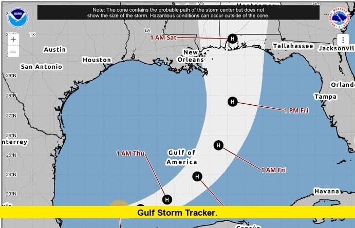

Gulf storm tracker updates show Hurricane Isaias strengthening over the Gulf of Mexico as the system moves toward the northern Gulf Coast, with dangerous wind, storm surge, flooding, and coastal hazards expected late Friday into Saturday.
The storm became the first Atlantic hurricane of the 2026 season on October 8. The National Hurricane Center reported maximum sustained winds of 80 mph early Thursday, with Isaias moving east-northeast at about 9 mph. Its central pressure was 979 millibars.
Isaias is now the main tropical threat across the Gulf of Mexico. Forecast guidance indicates additional strengthening before the storm reaches the northern Gulf Coast. The latest forecast places landfall within the warning area late Friday or early Saturday.
Where Hurricane Isaias Is Now
Early Thursday, Hurricane Isaias was positioned near 23.3 degrees north latitude and 91.2 degrees west longitude. That location puts the storm over the southwestern Gulf of Mexico, northwest of Mexico’s Yucatán Peninsula.
The hurricane was moving toward the east-northeast. Forecast projections show it continuing across the Gulf before turning toward the northern Gulf Coast.
The National Weather Service’s Gulf marine forecast places Isaias near 24.2 degrees north and 90.0 degrees west Thursday afternoon. By Friday morning, the projected position is near 25.9 degrees north and 88.6 degrees west. The forecast then carries the system toward 28.4 degrees north and 87.6 degrees west Friday afternoon.
Those positions show why the northern Gulf Coast has become the primary area of concern.
Isaias Is Expected to Strengthen Further
Current forecasts indicate that Isaias should continue strengthening through early Friday. The National Hurricane Center expects the hurricane to remain strong as it approaches the northern Gulf Coast Friday night.
The storm’s strengthening has already prompted officials to increase preparations along the coast. Hurricane and storm surge warnings are active for portions of the Gulf Coast, while additional watches cover areas farther inland.
Storm intensity can still change before landfall. However, the current forecast clearly identifies Isaias as a significant Gulf Coast threat rather than a weak tropical system.
The most important period for residents will be Friday afternoon through early Saturday, when strong winds, heavy rainfall, coastal flooding, storm surge, and dangerous surf conditions are expected to increase.
Northern Gulf Coast Landfall Risk
The current forecast calls for Isaias to reach the northern Gulf Coast late Friday or early Saturday. The exact landfall location can still shift as new advisories are issued, but the warning area already includes portions of the Florida Panhandle, Alabama, and Mississippi Gulf Coast region.
The National Weather Service office serving Mobile and surrounding areas reports increasing concerns for high winds, high surf, rip currents, storm surge, flash flooding, and tornadoes.
Florida’s western Panhandle is particularly important in the latest forecast. Hurricane warnings remain in effect for several locations, including parts of Okaloosa, Santa Rosa, and Escambia counties.
The warning area includes communities such as Destin, Fort Walton Beach, Santa Rosa Beach, Milton, and other locations near the Florida-Alabama border.
Florida Panhandle Conditions
The Florida Panhandle is facing several overlapping hazards from Isaias.
In coastal Okaloosa County, the latest local forecast calls for tropical-storm-force winds Friday afternoon through early Saturday morning. Peak winds are forecast around 45 to 55 mph, with higher gusts possible.
Parts of Santa Rosa County face a stronger wind threat. Forecast information for inland Santa Rosa County indicates potential peak winds of 55 to 75 mph, with gusts reaching as high as 95 mph. Hurricane-force winds are possible during the Friday-to-Saturday period.
Escambia County also remains under a significant threat. The local forecast includes potential hurricane-force winds, with the strongest conditions expected Friday evening.
These conditions could produce widespread power outages, tree damage, difficult travel, and dangerous conditions for anyone outdoors.
Alabama Gulf Coast Threat
Alabama is another major focus of the latest Gulf storm forecast.
The National Weather Service has issued hurricane and storm surge warnings for parts of the Alabama coast, while hurricane and tropical storm watches extend farther inland.
A flood watch is also in effect for portions of southern Alabama and northwest Florida from Friday afternoon into Saturday afternoon. The watch covers coastal and inland communities where excessive rainfall could overwhelm drainage systems and cause flooding.
Communities near Mobile Bay and the Alabama Gulf Coast could experience a combination of heavy rain, strong winds, storm surge, and dangerous coastal conditions.
Farther inland, the effects will depend on the storm’s exact track and rate of weakening. Current forecasts still indicate that strong winds and heavy rainfall could extend well away from the immediate shoreline.
Mississippi Could See Significant Impacts
Mississippi’s Gulf Coast also remains within the broader threat zone.
The latest forecast from the National Weather Service highlights the possibility of damaging winds, storm surge, flash flooding, and tornadoes across the region.
The storm’s east-northeast movement means the final location of landfall will play a major role in determining the severity of impacts across Mississippi. Even areas outside the center’s projected path can experience dangerous conditions from rainbands and coastal water rise.
Residents along the Mississippi Gulf Coast should therefore focus on official warning information rather than relying only on the center line shown on a storm map.
Storm Surge and Coastal Flooding
Storm surge remains one of the most serious concerns associated with Hurricane Isaias.
Storm surge occurs when hurricane winds push seawater toward the coast. The risk becomes greater when strong winds arrive at the same time as high tide or other unfavorable coastal conditions.
Current National Weather Service products show storm surge warnings along parts of the Florida Panhandle and Gulf Coast.
Coastal residents should also pay attention to water levels, wave conditions, and local evacuation instructions. Roads near beaches, bays, low-lying neighborhoods, and waterways can become dangerous before the strongest winds arrive.
Heavy Rain and Flash Flooding
Rainfall is another major part of the current Gulf storm threat.
The National Weather Service has issued a flood watch for parts of southern Alabama and northwest Florida. The watch covers the period from Friday afternoon through Saturday afternoon.
Heavy tropical rainfall can produce rapid flooding, especially in low-lying areas and locations with poor drainage. Creeks, streams, rivers, and urban drainage systems may respond quickly to intense rainfall.
Central Alabama is also expected to experience heavy rain and gusty winds as Isaias moves inland. The Birmingham National Weather Service office expects rainfall of roughly 2 to 4 inches, with locally higher amounts of up to 5 inches possible.
That rainfall could create flash-flood concerns, particularly in urban areas and places that already have drainage limitations.
Tornado Risk Along the Gulf Coast
Tropical systems can also produce tornadoes, particularly in rainbands on the eastern side of a landfalling storm.
The latest National Weather Service guidance identifies an isolated tornado threat as Isaias moves across the Southeast. Central Alabama could see an increased tornado risk east of Interstate 65 on Saturday.
Tornadoes associated with tropical systems can develop quickly. Their presence also means that people should not focus only on hurricane-force winds when preparing for the storm.
Residents should continue monitoring local weather warnings throughout Friday and Saturday, including severe thunderstorm and tornado alerts.
Gulf Waters Are Becoming Dangerous
Marine conditions are deteriorating across parts of the Gulf of Mexico.
The latest offshore forecast shows significant wave activity around Isaias, with peak seas near 20 feet reported in the storm’s vicinity.
Farther west, a tropical storm warning remains in effect for portions of the central Gulf. Forecast seas in some areas are expected to reach 6 to 10 feet through Friday and Saturday.
Swells generated by Isaias are also expected to reach the Yucatán Peninsula before spreading north toward the U.S. Gulf Coast. Those swells can create life-threatening surf and rip-current conditions even away from the hurricane’s center.
Beachgoers should take posted warnings seriously and avoid entering dangerous surf.
Texas Gulf Coast Outlook
The latest forecast is less threatening for southeast Texas than for areas farther east.
The Houston-Galveston National Weather Service office says Isaias is expected to remain well east of southeast Texas. However, Gulf seas and swells are expected to increase, with stronger rip currents and the potential for minor coastal flooding.
Marine conditions are still expected to become hazardous. A small craft advisory covers portions of the coastal waters, with northeast winds and elevated seas forecast.
This means Texas residents should not expect the same level of direct impact as communities near the central Gulf Coast, but coastal and marine hazards remain possible.
What the Gulf Storm Tracker Shows Next
The latest storm track points toward a continued east-northeast movement before Isaias reaches the northern Gulf Coast.
The current marine forecast projects the system inland near 31.0 degrees north and 87.6 degrees west Saturday morning. It is then expected to weaken into a tropical depression as it continues inland through the Southeast.
The forecast calls for Isaias to weaken as it moves away from the Gulf, but rainfall and strong winds can continue after landfall.
For people following the Gulf storm tracker, the most important changes to watch are the storm’s center position, maximum sustained winds, pressure, projected landfall area, hurricane warnings, storm surge warnings, and rainfall forecasts.
A shift of even a relatively small distance can change which communities experience the strongest winds and highest water levels.
Key Gulf Storm Tracker Updates
| Current concern | Latest status |
|---|---|
| Storm | Hurricane Isaias |
| Location | Southwestern Gulf of Mexico |
| Maximum sustained winds | 80 mph |
| Movement | East-northeast around 9 mph |
| Central pressure | 979 mb |
| U.S. threat | Northern Gulf Coast |
| Expected landfall | Late Friday or early Saturday |
| Main threats | Wind, storm surge, flooding, surf and tornadoes |
| Highest concern areas | Florida Panhandle, Alabama and Mississippi |
| Texas outlook | Mainly marine hazards and minor coastal flooding |
These conditions are changing as new advisories arrive, so residents should use the latest official warnings for decisions about travel, evacuation, sheltering, and other preparations.
Why the Latest Updates Matter
Hurricane forecasts become more useful as reconnaissance aircraft, satellite observations, radar, and other data improve the understanding of a storm’s location and strength.
Isaias has already strengthened significantly while crossing the Gulf. The latest National Hurricane Center information shows that additional strengthening is expected before the storm reaches the northern Gulf Coast.
That makes preparation time especially important for communities inside the warning area.
The most dangerous conditions are expected Friday into early Saturday, but coastal flooding, rough surf, and worsening marine conditions can begin before the center reaches land.
People in affected areas should keep emergency supplies accessible, follow local officials, and continue checking updated warnings rather than relying on an earlier forecast track.
Bottom Line
Hurricane Isaias is now the dominant Gulf Coast weather threat, with the storm strengthening over the Gulf of Mexico and heading toward the northern Gulf Coast. The Florida Panhandle, Alabama, and Mississippi face the greatest current concerns for damaging winds, storm surge, heavy rainfall, flooding, dangerous surf, and tornadoes.
The latest forecast calls for Isaias to approach the coast Friday and make landfall late Friday or early Saturday. Conditions can change quickly, so residents should continue following official warnings as the storm approaches.
Stay alert, follow the latest local warnings, and keep checking the storm track as Hurricane Isaias moves closer to the Gulf Coast.