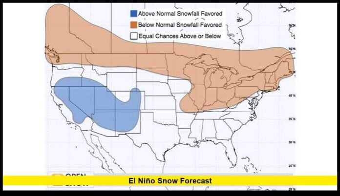

The el niño snow forecast is taking shape as a strong Pacific warming event continues to intensify, setting up a winter pattern that could bring major differences in snowfall across the United States.
The latest federal climate outlook shows El Niño strengthening during 2026, with more than a 90% chance of a very strong event during the Northern Hemisphere fall and winter. The strongest effects are expected to become more noticeable during the core winter months.
For snow lovers, the most important part of the forecast is not simply whether the United States will be wetter or warmer. Snow depends on several ingredients arriving together. Moisture, storm tracks and sufficiently cold temperatures all have to line up.
The current outlook points toward a wetter southern tier and parts of the West, while much of the northern United States has a stronger signal for above-normal temperatures. That creates a potentially favorable setup for mountain snow in parts of the Southwest and southern Rockies, while making widespread snow less favored across several northern areas.
El Niño Strengthens as Winter Approaches
The Pacific Ocean is showing a strong El Niño pattern heading into the 2026–27 cold season.
Recent observations show unusually warm water across the tropical Pacific. Ocean temperatures in the eastern equatorial Pacific have risen significantly, while atmospheric indicators are also supporting the developing event.
The latest climate assessment gives El Niño more than a 90% chance of reaching very strong intensity during fall and winter 2026–27.
That is a significant development for seasonal forecasting. A stronger El Niño generally produces a more recognizable atmospheric response, although its effects still vary from one region to another.
Forecast guidance indicates the event should continue strengthening into late 2026. The strongest phase is expected near the end of the year.
For U.S. snow conditions, that timing is important. The winter storm pattern usually becomes more strongly influenced by El Niño as the season progresses.
Why El Niño Matters for U.S. Snowfall
El Niño develops when tropical Pacific waters become warmer than normal across a large region of the equatorial Pacific.
That ocean warming changes atmospheric circulation. The changes can influence the position and strength of the jet stream, which in turn affects the paths followed by major winter storms.
During many El Niño winters, the southern branch of the jet stream becomes more active. Storms can travel across the southern United States and deliver moisture into regions that sometimes remain relatively dry during other winters.
At the same time, the northern part of the country often experiences warmer conditions.
This creates an important divide.
Southern states can receive more precipitation, while northern states can experience fewer favorable snow setups. But the relationship is never perfect. Individual storms can behave differently from the broader seasonal pattern.
That is why the current outlook should be used to identify areas with higher or lower probabilities rather than as a guarantee of a particular snowfall total.
California Emerges as an Important Snow Region
California is one of the most closely watched areas in the current outlook.
The latest seasonal guidance favors above-normal precipitation across much of California during the core winter period. The strongest precipitation signal becomes more prominent later in winter.
For California’s mountain ranges, additional precipitation can translate into additional snowfall when temperatures remain sufficiently cold.
The Sierra Nevada is especially important because of its elevation. Large Pacific storm systems can bring substantial moisture into the region, while temperatures at higher elevations remain cold enough for snow.
Lower elevations face a different situation.
A strong winter storm can produce heavy rain in coastal and valley communities while dumping significant snow over the mountains. As a result, a wetter seasonal outlook should not be interpreted as a statewide prediction for heavier snow.
For ski areas and mountain communities, elevation will remain one of the most important factors.
Southern California and Arizona Also Deserve Attention
The current outlook also increases precipitation chances across portions of southern Arizona during the winter.
This is relevant because El Niño can strengthen the southern storm track and increase moisture availability across the Southwest.
Snowfall remains concentrated at higher elevations. Cities and lower desert areas do not share the same snow potential as mountain locations.
The higher terrain of Arizona can benefit when moisture-rich storms interact with colder air. The exact amount of snow will depend on individual storm systems.
The broader seasonal signal is therefore more useful for identifying enhanced precipitation potential than for predicting specific snow totals.
Southern Rockies Could See More Winter Activity
The southern Rockies are another important part of the developing pattern.
Colorado, Utah, New Mexico and nearby areas can experience significant snowfall when Pacific moisture moves inland and temperatures remain cold enough at elevation.
El Niño has historically been associated with increased winter precipitation and snowfall across portions of the southern Rockies and Southwest.
The current outlook supports increased precipitation across much of the region.
However, Colorado and surrounding states sit within a complicated transition zone. Conditions can vary substantially from one mountain range to another.
Higher elevations generally have a stronger chance of converting additional precipitation into snow. Lower elevations can see rain or mixed precipitation during warmer storm systems.
This makes elevation, storm track and timing critical to the final seasonal outcome.
Pacific Northwest Faces a Less Favorable Snow Setup
The Pacific Northwest is receiving a very different signal.
The region has a strong background tendency toward warmer conditions as the 2026–27 winter approaches. The seasonal climate outlook also favors below-normal precipitation across portions of northern and eastern Washington and nearby inland areas during the fall period.
Historically, El Niño winters often produce a less favorable snowfall pattern across much of the Pacific Northwest.
The storm track can shift farther south, allowing more moisture to reach California and the southern tier while reducing the frequency of favorable snowstorms farther north.
That does not mean Washington, Oregon or Idaho will avoid snow.
Individual winter storms can still produce heavy mountain snowfall. Cold-air outbreaks can also temporarily override the broader seasonal pattern.
The key point is that the seasonal background does not currently favor widespread above-normal snowfall across the Pacific Northwest.
Northern Rockies Could Also See Reduced Snow Potential
The northern Rockies face similar challenges.
El Niño often shifts the atmospheric circulation in a way that favors warmer conditions across northern parts of the country. The current seasonal outlook also maintains a significant warm signal across the Pacific Northwest, northern Rockies and adjacent areas.
That can make it harder for precipitation to consistently fall as snow.
Mountain snowfall can still occur during individual storms. However, the combination of warmer seasonal temperatures and less favorable storm positioning creates a weaker setup for widespread above-normal snowfall.
This distinction matters because a region can receive several major snowstorms and still finish the season near or below its average if warm periods dominate the rest of winter.
The Northeast Has a Complicated Snow Outlook
The Northeast is another region where the latest pattern requires careful interpretation.
Much of the northern United States has an elevated probability of above-normal temperatures during the core winter period. That signal extends toward the Northeast.
Warmer seasonal temperatures can reduce the number of storms that produce snow at lower elevations.
But a warmer winter does not eliminate snowstorms.
The Northeast can experience powerful winter systems when cold air is present at the right time. A single major storm can produce a large share of the season’s snowfall.
Therefore, the current seasonal pattern should not be interpreted as a prediction of a snowless winter.
Instead, the warmer background suggests that snowfall may be less consistent than it would be under a colder seasonal regime.
Mountain and interior locations may have better opportunities to maintain snow than coastal and lower-elevation areas.
Great Lakes Snowfall Remains Highly Dependent on Cold Air
The Great Lakes region also faces a warmer-than-normal background signal.
That matters because lake-effect snow requires a particular combination of cold air, open water and favorable wind direction.
If temperatures remain warmer for longer periods, opportunities for major lake-effect snow events can decrease.
However, El Niño does not control every short-term weather pattern.
Cold outbreaks can still occur. When sufficiently cold air crosses the Great Lakes, heavy localized snow remains possible.
The seasonal signal therefore provides context rather than a precise prediction for individual lake-effect events.
Southeast Could Become Wetter During Winter
The Southeast has one of the stronger precipitation signals in the current outlook.
El Niño winters commonly increase storm activity across parts of the southern United States. The latest seasonal guidance reflects that broader pattern, with above-normal precipitation favored across significant portions of the Southeast during the winter.
But more precipitation does not automatically mean more snow.
Temperatures are the deciding factor.
Much of the Southeast normally experiences limited snowfall, so a wetter winter can simply mean more rain. Snow or wintry precipitation requires a sufficiently cold air mass to arrive while moisture is available.
When those ingredients overlap, the region can experience impactful winter weather.
The current outlook supports increased precipitation potential, but it does not provide enough information to promise a snowy season for individual Southern cities.
Southern Plains Could Become More Active
The Southern Plains are also positioned near the developing wetter pattern.
Texas, Oklahoma and surrounding areas can experience significant winter storms when Pacific moisture moves into the region while cold air pushes south.
The same storm can produce different types of precipitation across a relatively short distance.
Snow may fall farther north or at higher elevations, while freezing rain, sleet or rain occurs farther south.
That makes the Southern Plains particularly sensitive to small changes in storm track and temperature.
The broader outlook favors increased precipitation potential, but local snowfall totals cannot yet be determined with confidence for the full winter season.
Why More Rain Does Not Always Mean More Snow
One of the biggest mistakes when interpreting a seasonal snow outlook is treating precipitation and snowfall as the same thing.
They are not.
A location can have an above-normal precipitation forecast while having near-normal or below-normal snowfall.
Consider a winter storm crossing the southern United States. If temperatures remain above freezing near the surface, most of the precipitation will fall as rain.
Move the same storm into a higher mountain range, and colder temperatures can convert much of that moisture into snow.
This difference is especially important during El Niño winters.
The southern tier can receive more moisture, but temperatures vary dramatically across the region. Higher elevations therefore have a much better chance of turning the wetter pattern into significant snow.
Strong El Niño Does Not Mean Record Snow Everywhere
The strength of the developing El Niño has attracted considerable attention, but intensity alone cannot determine snowfall across the United States.
A strong event increases the likelihood that classic El Niño atmospheric patterns will appear. It does not force every region to experience the same outcome.
The latest climate outlook itself emphasizes that even when the Pacific signal is strong, impacts are not guaranteed.
Historical seasons demonstrate why.
Some El Niño winters have produced extraordinary snow in one region while producing relatively little in another. Individual storm tracks can shift the distribution of snowfall dramatically.
This is particularly true for the Northeast, Great Lakes and northern Rockies, where short-lived cold-air outbreaks can have an outsized effect on seasonal snowfall.
When the Forecast Will Become More Useful
The current seasonal forecast provides valuable information about broad patterns.
It does not provide dependable storm-by-storm snowfall predictions for the entire winter.
Forecast confidence improves as individual weather systems move into shorter forecast ranges. At that point, meteorologists can examine storm tracks, temperatures, atmospheric moisture and precipitation type in much greater detail.
For people interested in snowfall, the most important period will come as winter approaches and the first major storm systems begin appearing in medium-range forecasts.
Seasonal guidance will remain useful for understanding the larger pattern, while shorter-range forecasts will determine actual snowfall events.
The Main U.S. Snow Signals for Winter 2026–27
The latest outlook can be summarized into several broad areas:
- California mountains: Stronger potential for above-normal precipitation and favorable mountain snow opportunities.
- Southwest: Wetter conditions are favored, with higher-elevation areas having better snow potential.
- Southern Rockies: Increased precipitation may support mountain snowfall when temperatures cooperate.
- Southeast: A wetter winter pattern is favored, but snow remains highly temperature-dependent.
- Southern Plains: Increased precipitation potential could support winter storms when cold air arrives.
- Pacific Northwest: Warmer conditions create a less favorable background for widespread seasonal snow.
- Northern Rockies: Warmer conditions may limit the consistency of snow-producing storms.
- Great Lakes: Warmer conditions could reduce opportunities for prolonged lake-effect snow, although individual events remain possible.
- Northeast: A warmer winter signal may reduce overall snow consistency, while major individual storms remain possible.
What the El Niño Snow Forecast Means Right Now
The latest picture is becoming increasingly clear.
The 2026–27 winter is developing under a strong and strengthening El Niño. The Pacific event is expected to become very strong, and its influence should become more apparent as winter approaches.
For the United States, the strongest precipitation signal is concentrated across parts of the southern tier and West.
That puts California, the Southwest and portions of the southern Rockies in a position to receive increased winter moisture. Higher elevations in these regions have the greatest potential to convert that moisture into snow.
Meanwhile, much of the northern United States has a warmer seasonal signal. That does not eliminate snow, but it can make sustained snow cover and frequent snowstorms less likely in some locations.
The Northeast and Great Lakes remain more complicated because individual cold-air outbreaks can create major storms even within a warmer seasonal pattern.
The biggest takeaway is that there is no single nationwide snowfall outcome tied to El Niño. The event is shaping a regional pattern, and elevation and temperature will determine how much of the additional moisture becomes snow.
As winter draws closer, the evolving snow pattern will become easier to read—share your thoughts in the comments and stay tuned for the latest updates.