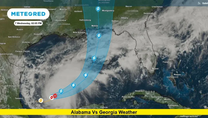

Alabama vs Georgia weather is becoming a major storyline ahead of Saturday night’s top-10 SEC matchup in Tuscaloosa, where Hurricane Isaias is expected to bring rain, strong winds and potentially dangerous conditions.
The game is scheduled for Saturday, Oct. 10, at Bryant-Denny Stadium in Tuscaloosa. Kickoff is set for 6:30 p.m. Central Time, or 7:30 p.m. Eastern. Alabama remains scheduled to host Georgia, and the latest university information still lists the game for Saturday night.
The weather concern comes from Hurricane Isaias, which strengthened into the first hurricane of the 2026 Atlantic season. The storm is moving toward the northern Gulf Coast and is expected to make landfall late Friday or early Saturday. Its inland effects are expected to extend into central Alabama during the weekend.
Latest Weather Update for Alabama vs. Georgia
The latest forecast shows a significant change from the hot, dry conditions expected across Tuscaloosa earlier in the week.
National Weather Service forecasters in Birmingham are warning that Hurricane Isaias will produce heavy rain and gusty winds across central Alabama from Friday night into Saturday. The current forecast calls for Saturday showers and possibly a thunderstorm in the Tuscaloosa area, with windy conditions.
The National Weather Service forecast for Tuscaloosa calls for a high near 77 degrees on Saturday. Rain chances are expected to remain high, while strong winds could become an important factor as the storm moves inland.
Current projections also indicate that the worst weather could occur during the broader game-day period rather than only during the afternoon.
That timing matters because the Alabama-Georgia game begins at 6:30 p.m. CT. Fans could encounter wet and windy conditions while traveling to the stadium, entering the venue and leaving after the game.
Hurricane Isaias Raises Game-Day Weather Concerns
Hurricane Isaias is the primary reason the forecast has become so unsettled.
The storm was located over the Gulf of Mexico early Thursday and had maximum sustained winds of 80 mph in the latest National Hurricane Center advisory. The hurricane was moving east-northeast at roughly 9 mph.
Forecasters expect Isaias to continue strengthening before approaching the northern Gulf Coast. Its exact track remains important because even relatively small changes can affect rainfall totals, wind speeds and the timing of the worst conditions in Tuscaloosa.
The storm is expected to make landfall somewhere along the northern Gulf Coast late Friday or early Saturday. After landfall, its circulation will continue moving inland across the Southeast.
Central Alabama is far enough inland to avoid the most extreme coastal impacts, but tropical systems can maintain dangerous conditions well away from the point of landfall.
For Tuscaloosa, the main concerns are heavy rainfall, strong wind gusts, flash flooding and the possibility of isolated tornadoes.
What the Tuscaloosa Forecast Shows
The latest National Weather Service forecast paints a much different picture for Saturday than the conditions expected Thursday.
Tuscaloosa is forecast to reach only the upper 70s on Saturday. The area is expected to experience widespread showers, with the possibility of thunderstorms and windy conditions.
Friday is expected to mark the beginning of the significant weather deterioration. Rain chances are expected to increase Friday night, with heavier rainfall possible as Isaias approaches the region.
By Saturday, the combination of tropical moisture and the storm’s circulation is expected to produce a wet and windy environment across central Alabama.
Current National Weather Service guidance for the broader central Alabama area indicates rainfall totals of roughly 2 to 4 inches, with locally higher amounts possible. Some locations could experience flash flooding, especially in areas with poor drainage.
Wind gusts could reach 40 to 50 mph across parts of central Alabama late Friday night and Saturday. Those winds could bring down tree limbs, trees and power lines.
For fans attending the game, the biggest issue may not be temperature. Instead, rain, wind and rapidly changing conditions are expected to dominate the forecast.
Will It Rain During the Alabama-Georgia Game?
The current forecast strongly supports the possibility of rain during the game.
The National Weather Service has forecast showers and potentially a thunderstorm for Saturday in Tuscaloosa. The stadium-specific forecast also indicates a substantial tropical-weather impact window extending from Friday night into early Sunday.
That means fans should not expect the typical mild October football conditions that Tuscaloosa often experiences.
The exact amount of rain falling between 6:30 p.m. and the end of the game remains dependent on Isaias’ track and forward speed. Tropical systems can change their rainfall patterns quickly as they move inland.
Still, the latest forecast provides enough confidence to say that wet conditions are a serious possibility.
Rain could affect the field, footing and ball handling if the heaviest precipitation occurs around kickoff or during the game. Strong wind could also become an issue for passing plays, kicking and punts.
The final hourly forecast will become more useful as the storm gets closer and forecasters receive additional observations from the Gulf and surrounding areas.
How Strong Could the Winds Be?
Wind is one of the most important parts of the current forecast.
The National Weather Service Birmingham office has warned that wind gusts could reach 40 to 50 mph across parts of central Alabama late Friday night through Saturday.
A stadium-focused forecast currently shows the potential for even higher peak gusts at Bryant-Denny Stadium during the broader storm period.
Strong gusts could create challenges outside the stadium. Fans walking through parking areas may encounter falling branches or other wind-related hazards.
Temporary structures, signs and unsecured objects can also become more dangerous when tropical winds increase.
The wind forecast will depend heavily on the final path of Isaias. A track farther west or closer to central Alabama could increase the threat, while a shift away from the region could reduce local impacts.
For that reason, the forecast should be treated as a changing situation rather than a fixed prediction.
Could Severe Weather Affect Tuscaloosa?
Severe weather is another concern associated with the hurricane’s inland movement.
Forecasters have identified a potential tornado threat across portions of Alabama on Saturday. The risk is expected to be greatest in areas east of Interstate 65, depending on the storm’s final track.
Tropical systems can produce tornadoes within rain bands even when the center of the storm is far from a particular location.
That makes weather monitoring especially important for anyone spending several hours outdoors around the game.
A tornado threat does not mean a tornado will occur at Bryant-Denny Stadium. However, the possibility is part of the broader severe-weather forecast and should not be ignored.
Heavy rainfall also creates a separate hazard. Several inches of rain over a relatively short period can overwhelm drainage systems and cause water to collect on roads and in low-lying areas.
Is the Alabama-Georgia Game Still Scheduled?
Yes. The latest official Alabama athletics schedule continues to list Georgia at Alabama on Saturday at 6:30 p.m. CT.
The University of Alabama has been monitoring the storm situation while remaining in communication with the SEC.
As of the latest update, there has been no official announcement moving, postponing or canceling the game.
That status could change if weather conditions create unacceptable safety concerns. Any schedule adjustment would require an official announcement from Alabama, Georgia or the SEC.
For now, the game remains scheduled for Bryant-Denny Stadium.
That is an important distinction because weather forecasts can change significantly during the final 24 to 48 hours before a tropical system reaches land.
What Fans Should Expect Saturday
Anyone attending the game should prepare for a very different experience from a typical October night in Tuscaloosa.
The most important conditions to watch are:
- Periods of heavy rain
- Strong wind gusts
- Possible thunderstorms
- Potential flash flooding
- A chance of isolated tornadoes
- Difficult driving conditions
- Possible delays caused by weather
- Cooler temperatures than earlier in the week
Fans traveling from Georgia may also encounter changing weather along the route to Tuscaloosa. The storm’s effects are expected to spread across multiple parts of the Southeast, meaning conditions may deteriorate well before fans reach the stadium.
Umbrella policies, parking arrangements and stadium-entry procedures can also become more important when rain and thunderstorms are possible. Fans should check official stadium and university updates before leaving for the game.
Why the Forecast Could Still Change
The biggest uncertainty remains the exact track of Hurricane Isaias.
Even though forecasters have a much clearer picture of the storm than they did earlier in the week, tropical systems can shift as new observations become available.
The National Hurricane Center continues to update the storm’s projected track, intensity and timing. Those updates can change the expected weather in Tuscaloosa.
A faster-moving storm could bring the most significant rain and wind through the area earlier. A slower system could extend the period of unsettled weather.
The final location of landfall also matters. A track closer to western Alabama could produce stronger effects in Tuscaloosa, while a more easterly track could change the rainfall and wind distribution.
This is why the Saturday morning forecast will be especially important for fans making final travel decisions.
Sunday Forecast Offers Some Improvement
The weather picture is expected to improve after the storm moves through.
Current forecasts call for mostly sunny conditions across Tuscaloosa on Sunday, with temperatures climbing back into the lower 80s.
That represents a significant improvement from Saturday’s forecast.
The quick change also highlights the tropical nature of the weather system. Conditions can deteriorate rapidly ahead of a storm and then improve quickly after its circulation moves away.
For Alabama and Georgia fans, however, the key period remains Friday night through Saturday evening.
What the Weather Means for the Matchup
The weather could become an important factor in how Alabama and Georgia approach the game.
Georgia enters the matchup ranked No. 2 nationally in the latest Associated Press Top 25. Alabama is ranked No. 6.
Both teams are undefeated entering the game, making Saturday’s contest one of the most important games of the early SEC season.
Wet and windy conditions can influence offensive strategy. Teams may rely more heavily on the running game if heavy rain makes passing difficult.
Wind can have an even greater impact on kicking and deep passing. A strong crosswind can change the trajectory of punts and field-goal attempts.
However, the weather alone will not determine the outcome. The intensity, timing and location of the worst conditions will matter much more than simply whether rain is present.
Alabama vs Georgia Weather Outlook
The latest outlook points toward a wet, windy and potentially disruptive Saturday in Tuscaloosa.
The biggest concerns are not simply a few passing showers. Forecasters are watching the potential for heavy rainfall, strong gusts, thunderstorms, flash flooding and isolated tornadoes as Hurricane Isaias moves inland.
The game remains scheduled for 6:30 p.m. CT at Bryant-Denny Stadium, but weather conditions will remain closely watched through Saturday.
The forecast should become more precise as Isaias approaches the Gulf Coast and additional observations improve the storm track.
For fans, the safest approach is to prepare for rain and wind while checking official Alabama and SEC announcements for any changes to the game schedule.
The latest Alabama vs Georgia weather forecast points to a challenging Saturday night in Tuscaloosa, so stay alert for new weather and game-status updates as kickoff approaches.