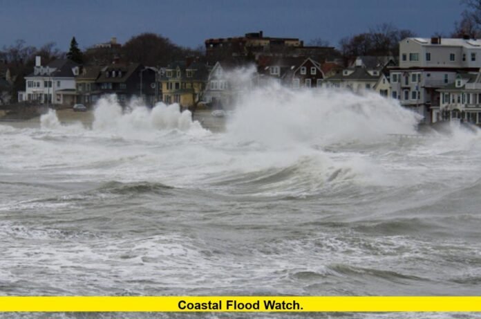

Coastal flood watch alerts are in effect across parts of the Northeast as a powerful coastal storm brings the threat of flooding, strong winds and high surf to the East Coast.
The National Weather Service has issued coastal flood watches for parts of Massachusetts and New York, while other coastal areas from the Mid-Atlantic into New England are under coastal flood warnings or advisories. The developing storm is expected to produce repeated high-tide flooding concerns through the weekend.
The latest National Weather Service outlook describes a strong coastal storm affecting the Mid-Atlantic and New England. The system is expected to bring coastal flooding, strong winds, heavy rain and high surf.
Because conditions vary considerably by location, residents should rely on the specific alert issued for their county or coastal community.
What Is the Latest Coastal Flood Watch Update?
The most significant current coastal flood watch activity is centered on parts of Massachusetts and New York.
In eastern Massachusetts, the National Weather Service has a coastal flood watch in effect from Friday afternoon through Saturday afternoon. The watch covers eastern Essex, Suffolk, eastern Norfolk, eastern Plymouth, Barnstable, Dukes and Nantucket counties.
Forecasters expect up to one foot of inundation above ground level in low-lying locations near shorelines and tidal waterways. The area is also facing a high surf threat, with breaking waves potentially reaching 6 to 17 feet in the surf zone.
The Boston-area forecast also includes a high wind watch. North winds of 20 to 30 mph could produce gusts reaching 50 mph in parts of eastern Massachusetts and Rhode Island.
New York also has coastal flooding concerns. Parts of Long Island are scheduled to move from a coastal flood advisory into a coastal flood watch Friday evening. The National Weather Service has listed the watch from Friday evening through Saturday morning for affected locations.
These watches mean forecasters expect conditions that could produce coastal flooding. The exact level of flooding will depend on storm conditions, tides, wind direction and the location of vulnerable areas.
Where Are Coastal Flood Watches Currently in Effect?
The coastal flood threat stretches across a broad section of the East Coast, but not every location has the same type of alert.
Current alerts include:
| Area | Current coastal alert | Main concern |
|---|---|---|
| Eastern Massachusetts | Coastal Flood Watch | Up to 1 foot of inundation in vulnerable areas |
| Long Island, New York | Coastal Flood Watch later Friday | Tidal flooding during high-tide cycles |
| Maryland coastal areas | Coastal Flood Warning/Advisory in places | Tidal inundation |
| Virginia coast | Coastal Flood Warning | Significant coastal flooding |
| Boston and surrounding areas | Coastal Flood Watch | Flooding, surf and strong winds |
| Rhode Island | Coastal flooding and high-wind concerns | Tidal flooding and damaging wind potential |
The distinction between a watch, warning and advisory is important.
A coastal flood watch indicates that conditions favorable for flooding are expected. A coastal flood warning indicates that flooding is occurring or considered imminent and potentially hazardous. A coastal flood advisory generally covers less severe flooding that can still create travel or property problems.
That means residents should not assume a coastal flood watch represents the same level of danger as a coastal flood warning.
Why Is the East Coast Facing Coastal Flooding?
The current threat comes from a strong coastal storm moving into a pattern capable of producing prolonged impacts along the Atlantic shoreline.
Strong onshore or northeasterly winds can push seawater toward the coast. When those winds coincide with high astronomical tides, water levels can rise enough to flood roads, parking areas, yards, docks and other low-lying locations.
The current system is also expected to generate large waves and prolonged periods of rough coastal conditions.
In Southern New England, forecasters are highlighting the possibility of a long-duration coastal storm from Friday through Sunday. Eastern and south-central Massachusetts, Rhode Island and eastern Connecticut are among the areas expected to experience the strongest impacts.
The storm is expected to combine several hazards rather than produce only a short period of coastal flooding.
How Much Coastal Flooding Is Expected?
Flooding amounts will vary by location.
In parts of eastern Massachusetts, the current coastal flood watch calls for up to one foot of inundation above ground level in low-lying areas near shorelines and tidal waterways.
Elsewhere along the Mid-Atlantic coast, the situation is more serious.
The National Weather Service has issued coastal flood warnings for portions of Virginia and Maryland. Along parts of the Virginia coast, forecasters expect two to three feet of inundation above ground level in vulnerable areas near shorelines and tidal waterways.
Parts of Maryland’s Eastern Shore are also under a coastal flood warning. The National Weather Service expects one to two feet of inundation above ground level in low-lying locations near shorelines and tidal waterways.
Those differences demonstrate why residents should check their local alert rather than relying on a single regional forecast.
When Is the Highest Coastal Flooding Risk?
The timing of high tide is one of the most important factors in determining when coastal flooding becomes most noticeable.
Flooding can worsen when elevated water levels coincide with high tide. Repeated high-tide cycles can also cause water to return to vulnerable locations several times during the storm.
In the Boston area, the coastal flood watch is scheduled to cover Friday afternoon through Saturday afternoon.
The broader Southern New England storm threat is expected to continue through Sunday, with multiple high-tide cycles potentially affected.
New York’s current coastal flood watch for portions of Long Island is scheduled for Friday evening through Saturday morning.
Residents in affected coastal communities should therefore pay close attention to local tide times and updated National Weather Service alerts.
How Strong Will the Winds Be?
Strong winds are another major part of the coastal storm threat.
A high wind watch is in effect for portions of eastern, northeastern and southeastern Massachusetts and northern and southern Rhode Island.
The National Weather Service expects north winds of approximately 20 to 30 mph, with gusts potentially reaching 50 mph.
Those winds can create several problems along the coast. Strong onshore flow can contribute to higher water levels, while gusty conditions can create dangerous travel conditions and cause tree limbs or power lines to fall.
The combination of wind and high water is particularly important for coastal communities because flooding and wind damage can occur at the same time.
What About High Surf?
High surf is also expected along portions of the New England coast.
A high surf advisory is scheduled to begin Friday in parts of Massachusetts. Large breaking waves of approximately 6 to 17 feet are possible in the surf zone.
High waves can create dangerous conditions even in locations that do not experience significant inland flooding.
Beachgoers, swimmers and people near jetties, rocks, piers and other exposed coastal structures should recognize that wave conditions can change rapidly during a strong coastal storm.
The combination of elevated water levels and large waves can also increase the risk of coastal erosion and damage to vulnerable shoreline infrastructure.
Coastal Flood Watch vs. Coastal Flood Warning
Understanding the alert terminology can help residents determine how seriously to treat the forecast.
A Coastal Flood Watch means flooding is possible because atmospheric and ocean conditions are becoming favorable.
A Coastal Flood Warning means hazardous coastal flooding is occurring, imminent or expected within the warning area.
A Coastal Flood Advisory generally indicates that less severe coastal flooding is expected, but the water can still create significant inconvenience, travel problems or localized property impacts.
The current East Coast storm includes all three types of alerts in different locations.
For example, parts of Massachusetts are under a coastal flood watch, while portions of Virginia and Maryland are already under coastal flood warnings.
Which Areas Are Most Vulnerable?
Low-lying coastal communities face the greatest immediate risk.
Potentially vulnerable locations include:
- Roads near tidal waterways
- Coastal parking lots
- Waterfront businesses
- Docks and marinas
- Low-lying neighborhoods
- Shoreline parks
- Areas around bays and tidal rivers
- Properties with a history of tidal flooding
The National Weather Service has already documented flooding concerns in parts of the Mid-Atlantic.
In Anne Arundel County, Maryland, officials expect up to one foot of inundation above ground level in low-lying shoreline areas. The National Weather Service specifically identified locations around Annapolis where elevated tides can affect businesses, parking areas and roads.
This illustrates how relatively modest increases in tidal water can create noticeable impacts in developed waterfront areas.
What Should Residents Do During a Coastal Flood Watch?
Residents in areas covered by a coastal flood watch should prepare before water levels rise.
Important steps include moving vehicles and valuable belongings away from flood-prone locations, securing outdoor objects and checking local emergency information.
People who live in areas that regularly flood during high tides should also be prepared for water to affect roads or parking areas.
During the storm, motorists should never drive through flooded roads when the depth or condition of the water is uncertain. Moving water can hide road damage, debris or other hazards.
Residents should also remember that a coastal flood watch can become a warning as the forecast becomes more certain.
How Long Will the Coastal Storm Last?
The current forecast points to a prolonged event rather than a brief coastal weather disturbance.
Southern New England could experience impacts from Friday through Sunday. The strongest winds and coastal flooding concerns are expected to develop as the storm becomes established near the region.
Boston’s forecast calls for increasing winds Friday and periods of rain Friday night into the weekend. Saturday and Sunday are expected to remain windy, with repeated chances for rain.
The extended nature of the system matters because several high-tide cycles could occur while strong winds and large waves continue.
What Happens Next With the Coastal Flood Watch?
The National Weather Service will continue monitoring water levels, wind conditions, tides and the storm’s movement.
A watch can be upgraded, extended, canceled or replaced with a warning as conditions change.
That makes updated local forecasts particularly important over the next several days.
Residents should use their local National Weather Service forecast office and emergency-management alerts for location-specific information. Conditions can differ substantially between communities only a short distance apart.
The latest forecast also indicates that the storm’s strongest effects are not limited to flooding. Strong winds, heavy rain and high surf could affect transportation, coastal infrastructure and outdoor activities.
Latest Coastal Flood Watch Outlook
As of September 24, the East Coast is dealing with a significant coastal storm threat extending from the Mid-Atlantic into New England.
The most important points are:
- Coastal flood watches are active for parts of Massachusetts and are scheduled for parts of Long Island.
- Coastal flood warnings are already affecting portions of the Mid-Atlantic.
- Parts of Virginia face two to three feet of expected inundation above ground level.
- Parts of Maryland face up to one to two feet of inundation in vulnerable coastal locations.
- Eastern Massachusetts could see up to one foot of inundation in low-lying areas.
- Strong north winds could reach 20 to 30 mph, with gusts up to 50 mph in parts of Massachusetts and Rhode Island.
- Large surf of 6 to 17 feet is possible along portions of the Massachusetts coast.
- Southern New England could experience prolonged storm impacts from Friday through Sunday.
The National Weather Service is describing the system as a strong coastal storm with potentially significant impacts across the Mid-Atlantic and Northeast. While the storm is being described as a nor’easter in broader weather coverage, the official forecasts emphasize the specific hazards rather than relying on the storm label.
The most important factor for residents is the alert affecting their own community. A coastal flood watch means flooding is possible, while a warning signals a more immediate threat.
The East Coast coastal threat is still evolving, so residents should continue checking local alerts and updated forecasts as the storm approaches.