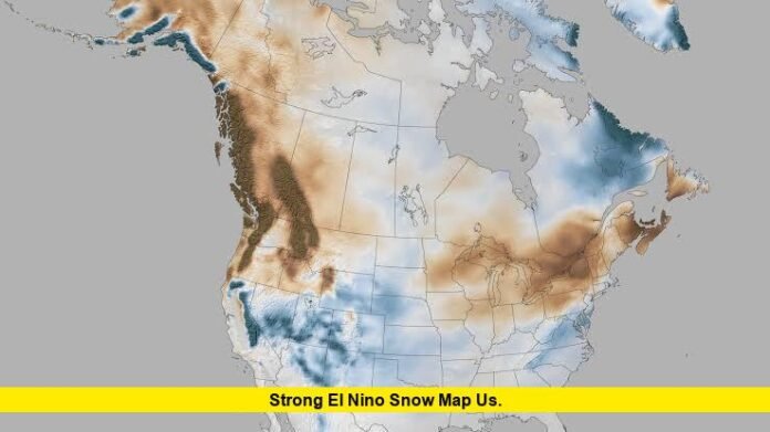

The strong el nino snow map us searches are surging as NOAA reports that El Niño is strengthening rapidly ahead of the 2026-27 winter. The latest NOAA Climate Prediction Center assessment says there is greater than a 90% chance of a very strong El Niño during the Northern Hemisphere fall and winter, while official seasonal outlooks are already showing a precipitation pattern consistent with many classic El Niño winters.
The search interest is significant right now. Google Trends shows the query “strong el nino snow map us” among rapidly rising U.S. searches, with more than 10,000 searches reported in recent trend data.
But there is an important distinction: there is not yet an official NOAA map predicting exact winter snowfall totals for every U.S. state. Instead, the available maps show seasonal temperature and precipitation probabilities, while historical El Niño snowfall patterns help indicate which regions may have better or worse snow prospects.
Strong El Niño Is Becoming a Major Winter Weather Signal
NOAA’s latest ENSO assessment says El Niño strengthened during the past month, with sea-surface-temperature anomalies exceeding 2 degrees Celsius in parts of the eastern equatorial Pacific.
The July Niño-3.4 index was +1.4°C, while the Niño-3 and Niño-1+2 regions were even warmer. NOAA says the coupled ocean-atmosphere system is showing a strengthening El Niño signal.
The most notable part of the forecast is the potential strength of the event.
NOAA’s official outlook currently gives a greater than 90% probability of a very strong El Niño during fall and winter 2026-27. It also estimates a 69% chance that the October-December period reaches a historically strong level, defined in the outlook as a three-month RONI value of at least +2.5°C.
That does not mean every El Niño consequence will automatically occur. NOAA emphasizes that stronger El Niño events increase the odds of characteristic impacts but do not guarantee a specific weather outcome in every location.
What the Strong El Niño Snow Map Shows
Historical snowfall patterns provide the clearest way to understand the potential snow distribution.
NOAA’s Climate.gov analysis finds that El Niño winters typically shift the Pacific jet stream southward and eastward. That configuration can send more moisture into the southern half of the United States.
The resulting snowfall signal is particularly important across the higher elevations of the West, where cold enough temperatures are more common.
Regions That Can See Increased Snow Potential
A typical strong-El Niño snowfall pattern favors several areas.
- California’s Sierra Nevada
- Nevada
- Utah
- Arizona’s higher elevations
- New Mexico
- Colorado and the central Rockies
- Parts of the Southern Plains
- Portions of the South and Southeast
- Some areas of the Mid-Atlantic and East
The strongest and most reliable snowfall signal is generally found where increased moisture intersects with sufficiently cold elevations.
That is why a simple map showing “more precipitation” should not automatically be interpreted as “more snow.” If temperatures remain too warm, additional winter precipitation can fall as rain instead.
Western U.S. Snow Potential Is Getting Attention
The latest NOAA seasonal outlook provides an important clue for the western snow pattern.
For the winter period, NOAA favors above-normal precipitation across a large portion of the western United States, extending from Southern California and the Desert Southwest into the Great Basin and Central Rockies.
That area overlaps some of the country’s most important mountain snow regions.
For ski areas and high-elevation communities, above-normal winter precipitation can become significant if temperatures remain cold enough for snow. California’s Sierra Nevada, the Wasatch Range in Utah, the Colorado Rockies and parts of the Great Basin could therefore be areas to watch as winter approaches.
However, the precipitation outlook should not be confused with a snowfall-total forecast.
NOAA’s seasonal maps are probability-based outlooks. They describe the odds of precipitation being above, near or below normal rather than predicting the exact number of inches that will fall.
California and the Sierra Nevada
California is one of the regions frequently associated with strong El Niño winters.
The southern and central portions of the state can become exposed to a wetter storm track, while the Sierra Nevada can benefit when atmospheric moisture arrives alongside sufficiently cold air.
The current NOAA seasonal outlook favors above-normal precipitation across Southern California and the broader Desert Southwest during portions of the coming seasons.
For mountain communities, the key question will be whether individual storms produce snow at elevation rather than rain.
That distinction will become much easier to assess later in the fall and winter, when short- and medium-range forecasts begin resolving individual storm systems.
Utah, Nevada and the Great Basin
The Great Basin is another region worth watching on a strong El Niño snow map.
NOAA’s seasonal outlook favors above-normal precipitation extending from Southern California and the Southwest into the Great Basin and Central Rockies.
This could create a favorable moisture pattern for mountain snow in parts of Utah and Nevada.
But again, El Niño alone cannot determine the final snowfall outcome. Storm timing, elevation, temperatures and the position of upper-level troughs will all influence whether the precipitation becomes snow.
Colorado and the Central Rockies
The Central Rockies also appear within the area of favored above-normal precipitation in the latest seasonal guidance.
That is significant because Colorado contains extensive high-elevation terrain where increased moisture can translate into substantial snowfall.
A strong El Niño does not mean every Colorado location will experience an unusually snowy winter. Mountain microclimates can produce large differences over relatively short distances.
For that reason, the most useful winter snow maps will come later, once NOAA and other forecasting centers have greater confidence in individual storm patterns.
What About the Pacific Northwest?
The Pacific Northwest is one of the regions where the historical El Niño snowfall pattern can be less favorable.
NOAA’s analysis of historical El Niño snowfall shows reduced snowfall across much of the northern United States, including the Pacific Northwest, northern Rockies and Great Lakes.
That does not mean the Pacific Northwest cannot receive major snowstorms during an El Niño winter.
Individual cold-air outbreaks can still produce significant snowfall. The larger climate pattern simply shifts the odds away from the region compared with areas farther south.
Great Lakes Snow Could Be More Complicated
The Great Lakes are another region where El Niño historically tends to suppress snowfall compared with La Niña.
A National Weather Service analysis of ENSO and snowfall notes a negative relationship between the Oceanic Niño Index and snowfall across the Great Lakes, meaning snowfall has generally been greater during La Niña winters than El Niño winters.
This is important because lake-effect snow is highly dependent on local temperatures, wind direction and lake temperatures.
A seasonal El Niño signal cannot eliminate individual lake-effect events, but it can alter the broader atmospheric setup in ways that affect the frequency and intensity of favorable lake-effect conditions.
Northeast and Mid-Atlantic Snow Potential
The Northeast is more complicated than a simple “El Niño means less snow” rule.
Historical research from the National Weather Service office serving Washington and Baltimore found considerable variability during strong El Niño winters. Of seven strong El Niño winters since 1950 examined in that analysis, four produced well-above-normal snowfall while three had virtually no snowfall.
That wide range demonstrates why El Niño should be treated as a background climate signal rather than a guarantee of a snowy or snowless winter.
Storm track and temperature will be crucial across the Mid-Atlantic and Northeast.
If a strong coastal storm develops while cold air is established over the region, snowfall can become significant even during an El Niño winter.
Why the Southern U.S. Could Be Wetter
El Niño typically strengthens the subtropical jet stream and shifts storm activity toward the southern United States.
The National Weather Service notes that the Gulf Coast generally becomes cooler and wetter during El Niño winters, with storm tracks farther south on average.
NOAA’s current seasonal guidance is consistent with this broader pattern.
Above-normal precipitation is favored across much of the southern tier from fall 2026 into spring 2027, with probabilities exceeding 60% in parts of the Southeast during portions of the winter season.
More precipitation does not necessarily mean more snow in the South. Temperatures will frequently be too warm for snow, particularly near the Gulf Coast.
Instead, the wetter pattern may mean more rain and stronger storm systems, with snow becoming more likely farther north or at higher elevations.
Is There an Official 2026-27 Snowfall Map Yet?
Not in the sense many people expect.
NOAA has already issued long-range temperature and precipitation outlooks extending through winter 2026-27. Its current seasonal products include outlooks for December-January-February 2026-27 and January-February-March 2027.
Those maps are useful for understanding the large-scale pattern, but they are not equivalent to a map saying that a particular state will receive a certain number of inches of snow.
A reliable snowfall forecast requires much shorter-range information.
As winter approaches, forecasters will be able to evaluate:
- Individual storm tracks
- Arctic air intrusions
- Atmospheric blocking
- Jet-stream position
- Snow levels
- Mountain temperatures
- Gulf and Pacific moisture
- Coastal storm development
- Lake-effect conditions
These factors can determine whether a seasonal precipitation surplus actually becomes a snowy winter.
Strong El Niño Snow Map US: Region-by-Region Outlook
| Region | Typical Strong El Niño Snow Signal | What to Watch |
|---|---|---|
| California Sierra | More favorable | Pacific moisture and cold mountain temperatures |
| Nevada | More favorable in higher terrain | Storm track and elevation |
| Utah | More favorable | Great Basin moisture and temperatures |
| Arizona high country | Potentially favorable | Elevation and cold air |
| New Mexico | Potentially favorable | Southern storm track |
| Colorado Rockies | More favorable precipitation | Mountain temperatures |
| Pacific Northwest | Often less favorable | Northern storm-track changes |
| Northern Rockies | Often less favorable | Cold-air availability |
| Great Lakes | Often less favorable | Lake-effect setup |
| Southeast | Wetter, but snow variable | Cold-air timing |
| Mid-Atlantic | Highly variable | Coastal storms and blocking |
| Northeast | Highly variable | Storm track and cold air |
Why a Strong El Niño Does Not Guarantee a Snowy Winter
One of the biggest misconceptions surrounding seasonal snow maps is treating an El Niño classification as a direct snowfall forecast.
It is not.
El Niño changes the probability of certain atmospheric patterns. It does not control every weather system for several months.
The National Weather Service notes that even strong El Niño winters can produce dramatically different snowfall outcomes in the Mid-Atlantic.
The same principle applies nationally.
A strong El Niño can favor a wetter southern storm track, but if cold air is absent, precipitation will fall as rain. Conversely, a single major storm can produce substantial snow in an area where the seasonal signal is otherwise unfavorable.
What the Latest NOAA Outlook Means for Winter 2026-27
The overall message from NOAA is becoming clearer: El Niño is strengthening and could become one of the strongest events in the historical record.
NOAA’s August assessment placed the probability of a very strong event above 90%, while the official outlook indicated a 69% chance of an October-December event reaching a historically strong threshold.
At the same time, NOAA’s seasonal precipitation outlook points toward wetter conditions across significant portions of the West and southern United States.
For snowfall watchers, that combination makes the Sierra Nevada, Great Basin, Southwest and Central Rockies particularly important areas to monitor as winter approaches.
The northern tier, including the Pacific Northwest and Great Lakes, has a less favorable historical snowfall signal under El Niño.
The East Coast remains much harder to predict because individual storm tracks and cold-air availability can overwhelm the seasonal ENSO signal.
When Will the Snow Forecast Become More Reliable?
The strongest seasonal signals are already becoming visible, but exact snowfall forecasts are still months away.
For now, the best approach is to use NOAA’s seasonal outlooks to identify broad patterns rather than specific snowfall totals.
As October and November arrive, forecasts should provide more information about developing cold-air patterns and storm tracks. By December, forecasters can generally provide much more useful guidance about individual snow events.
That means the current strong el nino snow map us discussion is best viewed as a map of potential and probability, not a final prediction for how many inches each state will receive.
Bottom Line
The latest NOAA data point toward a potentially exceptional El Niño for winter 2026-27, with a greater than 90% chance of a very strong event. Historical El Niño patterns and current seasonal outlooks favor increased precipitation across parts of the southern and western United States, particularly from Southern California through the Great Basin and Central Rockies.
For snow lovers, the higher elevations of the Sierra Nevada, Great Basin, Southwest and Rockies are among the regions worth watching most closely. The Pacific Northwest and Great Lakes generally have a less favorable historical snowfall signal, while the Mid-Atlantic and Northeast remain highly dependent on individual storm tracks and cold-air availability.
The important takeaway is that strong El Niño raises the odds of certain winter patterns, but it does not guarantee a specific snowfall outcome for any state or city.
Are you expecting a snowy winter where you live? Share your state below and stay tuned for the latest 2026-27 snow and El Niño updates.