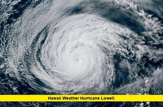

Hawaii weather is being closely monitored as Hurricane Lowell moves west across the Central Pacific and prepares for a possible turn toward the islands. The latest National Hurricane Center advisory places Lowell about 595 miles south of Lihue and 555 miles southwest of Honolulu, with maximum sustained winds of 125 mph.
The storm remains a major hurricane, although its intensity has decreased from its earlier peak. Forecasters continue to watch its track because Lowell is expected to turn toward the northwest and north during the weekend. That change could bring increasingly significant weather impacts to Hawaii early next week.
Hurricane Lowell Current Status
As of the latest available Central Pacific Hurricane Center information, Hurricane Lowell is a Category 3 hurricane on the Saffir-Simpson Hurricane Wind Scale.
The latest confirmed statistics are:
| Hurricane Lowell detail | Latest information |
|---|---|
| Current category | Category 3 |
| Maximum sustained winds | 125 mph |
| Minimum central pressure | 947 mb |
| Current movement | West at 9 mph |
| Position | 13.4°N, 159.6°W |
| Distance from Lihue | About 595 miles south |
| Distance from Honolulu | About 555 miles southwest |
| Hurricane-force winds | Extend up to about 45 miles |
| Tropical-storm-force winds | Extend up to about 140 miles |
The National Hurricane Center said Lowell is moving west at about 9 mph. The system is expected to slow gradually during the next day or two before turning northwest and then north this weekend.
That forecast change is especially important for Hawaii. A storm moving west and remaining well south of the islands presents a different threat than one turning north closer to the island chain.
At this point, the precise impacts remain dependent on Lowell’s eventual track and intensity.
Lowell Has Weakened, But It Remains a Major Hurricane
Lowell has undergone notable changes in strength during its approach toward the Central Pacific.
Earlier Thursday, the hurricane had maximum sustained winds of 140 mph and was classified as a Category 4 hurricane. By the 11 p.m. HST advisory, winds had fallen to 125 mph, making Lowell a Category 3 hurricane.
The reduction in strength does not eliminate the threat.
The National Hurricane Center expects Lowell to remain a major hurricane through the weekend. The latest forecast advisory also shows the possibility of some strengthening after the current period of weakening.
Forecasters are also watching an eyewall replacement cycle. Satellite imagery showed that Lowell’s eye had become less distinct, while deep thunderstorms continued around the eyewall. Microwave observations indicated a double-eyewall structure.
Eyewall replacement cycles can cause hurricanes to fluctuate in intensity. They can also change the size and distribution of the strongest winds.
For Hawaii, the key issue is therefore not simply Lowell’s current category. The storm’s future direction, size, intensity and distance from the islands will determine the eventual weather impacts.
Hawaii Weather Today as Lowell Moves West
The immediate Hawaii weather pattern remains influenced by both the hurricane and the broader pressure pattern across the Central Pacific.
The Honolulu National Weather Service office says a high-pressure ridge north of Hawaii and Lowell passing south of the islands will keep trade winds breezy on Friday. Passing showers are expected, particularly around windward mountain areas, with brief showers possible in leeward locations.
The weather pattern is expected to change over the weekend.
As a low-pressure trough moves into the Central Pacific, the ridge north of Hawaii is expected to weaken. That should allow wind speeds to decrease. Lowell, meanwhile, is forecast to begin drifting northward later in the weekend.
This combination is important because it could allow the hurricane to approach the western Hawaiian Islands more closely than it would have if it maintained a straightforward westward track.
The National Weather Service says the westernmost islands could see impacts from Lowell from Monday into Tuesday, although the forecast remains subject to change as the storm’s track develops.
Which Hawaiian Islands Face the Greatest Concern?
The western Hawaiian Islands currently have the greatest concern in the official forecast.
Kauai is particularly important because Lowell’s projected path could bring the storm closer to the island than to Hawaii Island or Maui.
Recent local forecasts have highlighted the possibility of rain, strong winds, dangerous surf and flooding, especially across the western portion of the state. The exact severity depends on how far north Lowell turns and how strong it remains.
Oahu is also being closely watched.
The City and County of Honolulu said officials are monitoring Lowell as it moves south of the Hawaiian Islands and encouraged Oahu residents to remain aware of the forecast heading into the Labor Day weekend.
However, it is important not to confuse potential impacts with a confirmed landfall.
The current information does not establish that Lowell will make landfall on any Hawaiian island. Forecast uncertainty remains, and the storm’s expected northward turn is still a major factor in determining how close it will come to land.
Dangerous Surf Is Already a Hawaii Weather Concern
Surf conditions are one of the clearest current impacts from Lowell.
The National Weather Service says swells generated by Lowell have already reached Hawaii and are expected to remain elevated. Those swells can create dangerous surf and rip currents even while the hurricane center remains hundreds of miles away.
The latest Hawaii surf forecast indicates elevated conditions through Saturday. Forecasters are also watching for potentially much larger surf early next week if Lowell follows the expected track toward the western islands.
The potential problem extends beyond beaches.
Large waves combined with high tides could affect harbor entrances, channels, coastal roads and other infrastructure. The National Weather Service says the eventual Lowell track and intensity will play a major role in determining the size of next week’s swells.
For beachgoers and boaters, this means conditions can become hazardous before the storm itself reaches the vicinity of Hawaii.
Rain and Flooding Threat Could Increase Next Week
Rainfall is another developing concern.
The Weather Prediction Center’s Hawaii extended forecast discussion says Lowell’s projected track could transport unusually moist air northward across the state from Sunday night through Wednesday afternoon.
The heaviest rainfall potential currently favors the western islands, particularly Kauai and Oahu.
However, the moisture associated with Lowell could reach other parts of the state as well. That means residents should not assume that only the western islands could experience increased rainfall.
Heavy rain can create flooding concerns, especially when tropical moisture combines with mountainous terrain.
The National Weather Service has therefore emphasized the need to continue monitoring the forecast rather than relying on a single projected track.
Strong Winds Are a Potential Threat
Wind conditions are another major part of the Lowell forecast.
The hurricane currently has hurricane-force winds extending outward up to approximately 45 miles from its center. Tropical-storm-force winds extend much farther, up to about 140 miles.
That wind field can expand or change as the hurricane evolves.
Hawaii is already experiencing breezy trade winds. Oahu, for example, was forecast to have northeast winds of 20 to 25 mph on Friday, while Maui was expected to have east winds of 15 to 20 mph.
Those winds are not the same as direct hurricane conditions from Lowell.
Instead, they are part of the existing Hawaii weather pattern while Lowell remains south of the island chain.
The more significant wind threat would develop if Lowell approaches the western islands closely enough for tropical-storm-force or hurricane-force winds to reach land.
No Coastal Watches or Warnings Were in Effect in the Latest Advisory
As of the latest 11 p.m. HST Thursday advisory, the National Hurricane Center reported that there were no coastal watches or warnings in effect for Hawaii.
That status is important because it shows that officials had not yet issued a coastal tropical cyclone watch or warning at the time of the latest advisory.
It does not mean the threat has ended.
The National Hurricane Center specifically instructed interests in the Hawaiian Islands to continue monitoring Lowell.
Because Lowell’s forecast turn is expected during the weekend, watches or warnings could become necessary if the projected track brings the hurricane closer to the islands.
Residents should rely on official updates rather than older forecasts or social media posts.
Why Lowell’s Track Is So Important
The difference between a storm passing south of Hawaii and a storm turning north near the islands can be substantial.
Lowell is currently moving west. The forecast calls for a gradual slowdown followed by a northwest and northward turn during the weekend.
That means the storm’s position over the next several forecast periods will be critical.
Even a relatively small change in the timing or location of the turn could shift the areas most exposed to strong winds, heavy rain and dangerous surf.
The forecast is also complicated by changes in Lowell’s internal structure.
The Central Pacific Hurricane Center reported an eyewall replacement cycle and some weakening on the latest advisory. At the same time, the storm remains over warm water and in an environment that could support renewed strengthening.
Consequently, both track and intensity deserve close attention.
What Hawaii Residents Should Watch This Weekend
The most important developments will involve the hurricane’s direction, intensity and distance from the islands.
Residents should watch for:
- Changes in Lowell’s forecast track.
- Any new tropical storm or hurricane watches.
- Changes in projected arrival times for strong winds.
- Updates to rainfall and flooding forecasts.
- Changes in surf forecasts.
- New guidance for Kauai and Oahu.
- Changes in Lowell’s intensity as the eyewall cycle evolves.
The National Weather Service and Central Pacific Hurricane Center will continue updating forecasts as new observations become available.
People living in or visiting Hawaii should avoid relying on a single forecast graphic because tropical cyclone tracks can shift as new information enters forecasting models.
Hawaii Weather Forecast Through Early Next Week
Friday is expected to remain breezy, with passing showers focused mainly on windward and mountain areas. The weather pattern should become less dominated by the current trade-wind setup as the weekend approaches.
By Sunday night, moisture associated with Lowell could begin moving north across Hawaii. That moisture is expected to increase the potential for locally heavy rainfall.
Monday and Tuesday are currently the key period to watch for potential direct effects from Lowell, particularly across the western Hawaiian Islands.
The National Weather Service says Lowell may bring impacts to the westernmost islands during that period, while the exact track and associated effects continue to evolve.
Surf conditions could also become more dangerous early next week. Current forecasts indicate the possibility of extra-large surf along south- and west-facing exposures if the hurricane’s eventual track supports that outcome.
Bottom Line on Hawaii Weather and Hurricane Lowell
Hurricane Lowell remains a powerful Central Pacific hurricane with 125 mph sustained winds as of the latest available advisory. It is moving west about 9 mph and remains hundreds of miles south of the Hawaiian Islands.
The immediate Hawaii weather pattern includes breezy winds, passing showers and elevated surf. The more significant concern comes later this weekend and early next week, when Lowell is forecast to turn northwest and north.
Kauai and Oahu currently deserve particular attention because the official forecasts point toward greater potential impacts in the western portion of Hawaii. Heavy rain, flooding, strong winds and dangerous surf are all possible hazards if Lowell approaches closely enough.
There is still no confirmed landfall forecast. The latest official information instead emphasizes continued monitoring because the storm’s track and intensity can change.
Stay with the latest official forecasts as Hurricane Lowell approaches its weekend turn, and share your thoughts on the evolving Hawaii weather threat in the comments.