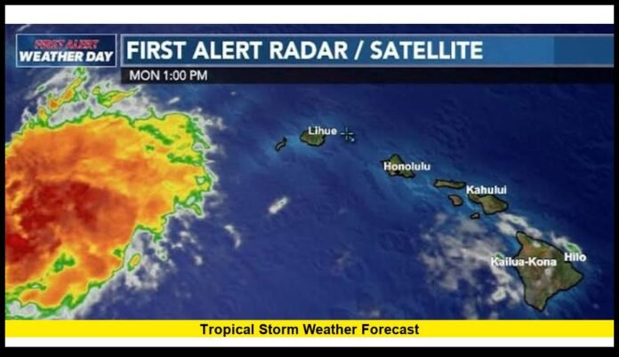

The tropical storm weather forecast remains an important focus for communities across the Atlantic, Pacific and other tropical regions as meteorologists monitor developing weather systems and changing atmospheric conditions. As of the latest update, tropical activity is notably different from one basin to another, with the Atlantic relatively quiet while the Central Pacific is dealing with Hurricane Lala and additional disturbances are being watched elsewhere.
Tropical weather can change rapidly, particularly during the heart of hurricane season. A system that appears weak can sometimes strengthen quickly when it encounters warm ocean water, favorable upper-level winds and abundant moisture. For that reason, residents and travelers should pay attention to official forecast updates rather than relying on a single prediction.
Tropical Weather Activity Is Uneven Across the Basins
The current tropical pattern is not uniform. Some regions have little immediate threat, while other areas are experiencing active storms or monitoring new disturbances.
In the Atlantic, the National Hurricane Center’s latest outlook indicates that tropical cyclone formation is not expected in the Atlantic, Caribbean Sea or Gulf of America during the next seven days. An eastern Atlantic tropical wave is being monitored, but the overall environment remains less supportive of rapid development.
The situation is considerably different in the Central Pacific, where Hurricane Lala has become a major hurricane while moving generally west-northwestward away from the main Hawaiian Islands.
This contrast demonstrates why broad statements about whether the hurricane season is “active” or “quiet” can be misleading. Conditions can be unfavorable in one basin while a significant storm develops in another.
Hurricane Lala Remains the Main Pacific Concern
Hurricane Lala is currently the most significant tropical system affecting the Central Pacific forecast picture.
Recent National Hurricane Center information shows Lala strengthening to major-hurricane intensity while moving away from Hawaii. The storm has produced dangerous conditions in parts of the Central Pacific, and hurricane warnings have been issued for portions of the Northwestern Hawaiian Islands.
The storm’s location and direction are especially important because Lala is not simply a typical tropical disturbance. Its development has demonstrated how quickly a tropical system can intensify when environmental conditions become favorable.
Forecast discussions indicate that Lala is expected to remain a hurricane for a period before gradually weakening. However, even when a storm begins weakening, dangerous surf, strong winds, rainfall and coastal flooding can continue.
Residents should therefore avoid assuming that a reduction in wind speed automatically means the threat has disappeared.
Hawaii Continues to Monitor the Effects of Tropical Activity
Hawaii has already experienced impacts associated with Lala as the storm passed through the broader region.
Even when the center of a tropical cyclone stays away from the most populated islands, outer rainbands and large swells can produce hazardous weather. Heavy rain can increase the risk of flooding, while strong winds can affect exposed locations.
The Northwestern Hawaiian Islands are particularly important in the current forecast because Lala’s projected path brings the storm closer to that region.
For residents and visitors, the most useful information comes from local emergency management agencies and official weather advisories rather than long-range social media forecasts.
Atlantic Hurricane Season Remains Relatively Quiet
The Atlantic basin is currently much quieter than many people might expect for August.
The latest official outlook says tropical cyclone formation is not expected across the North Atlantic, Caribbean Sea and Gulf of America during the next seven days. That does not mean the Atlantic season is finished or that tropical storms cannot develop later.
August and September remain important months for Atlantic hurricane activity. A quiet period can be followed by a sudden increase in development when atmospheric conditions change.
The current lack of immediate development should therefore be viewed as a short-term forecast rather than a guarantee for the rest of the season.
Why the Atlantic Is Seeing Less Development
Several environmental factors can influence whether tropical systems develop.
One of the most important is wind shear. Strong changes in wind speed or direction with height can disrupt the circulation of a developing tropical cyclone and prevent thunderstorms from organizing around a central low-pressure area.
Dry air can also interfere with storm development. Tropical cyclones generally need substantial moisture to maintain organized thunderstorms.
Other factors include:
- Sea-surface temperatures
- Atmospheric moisture
- Upper-level pressure patterns
- Tropical wave activity
- Large-scale circulation patterns
- The position and strength of nearby weather systems
These ingredients can change over relatively short periods, which is why meteorologists continually update their forecasts.
A Tropical Wave in the Atlantic Is Being Monitored
Although there is no immediate expectation of tropical cyclone formation across the Atlantic, forecasters continue watching tropical waves moving across the basin.
A tropical wave is an elongated area of relatively lower pressure that can produce showers and thunderstorms. Most tropical waves never become named storms.
However, under the right conditions, a tropical wave can gradually develop a more organized circulation.
That is why forecasters monitor these features several days before they have any realistic chance of becoming tropical depressions or storms.
For people living along the U.S. Gulf Coast, Florida, the Southeast and the Caribbean, early awareness is useful even when there is no immediate threat.
Eastern Pacific Activity Also Deserves Attention
The eastern Pacific remains another important region to watch.
Forecast centers are monitoring disturbances in the basin, including an area identified for possible development farther west of Mexico. Not every disturbance will become a tropical cyclone, but warm water and favorable atmospheric conditions can allow systems to organize.
Storms in the eastern Pacific frequently move westward over open water, although some systems can approach Mexico, Baja California or other Pacific-facing locations.
The eastern Pacific also has implications for Hawaii because storms can move westward toward the Central Pacific.
This is one reason forecasters monitor systems long before they reach the vicinity of the Hawaiian Islands.
What the Latest Forecast Means for U.S. Residents
For most of the continental United States, the current tropical situation does not indicate an immediate widespread hurricane threat.
The Atlantic’s lack of expected tropical development during the next seven days provides some short-term relief for the Gulf Coast, Florida and the East Coast.
However, coastal residents should not use a quiet week as a reason to delay hurricane preparation.
Hurricane season preparation is most effective before a storm forms. Once a named system approaches land, stores can run short of supplies and evacuation routes can become crowded.
Basic preparation should include:
- Checking emergency supplies
- Reviewing evacuation routes
- Keeping important documents accessible
- Charging phones and backup batteries
- Securing loose outdoor objects
- Knowing local shelter information
- Monitoring official weather warnings
Why Storm Intensity Can Change So Quickly
One of the biggest challenges in tropical forecasting is predicting intensity.
A storm can strengthen rapidly when it encounters very warm water and favorable atmospheric conditions. Conversely, interaction with dry air, strong wind shear or cooler water can cause a storm to weaken.
This is why a forecast issued several days ahead should not be interpreted as a fixed outcome.
Meteorologists continuously compare satellite observations with computer forecast models and real-time atmospheric measurements.
If the storm’s structure changes, the forecast may change as well.
Understanding the Cone of Uncertainty
The familiar forecast cone shown on tropical cyclone maps represents the probable track of the center of a storm over a specified period.
It is important to understand what the cone does not mean.
The entire area inside the cone is not expected to receive hurricane conditions. Similarly, locations outside the cone can still experience dangerous weather.
A storm is much larger than its center, and rain, wind, storm surge and tornado risks can extend well away from the forecast track.
People should therefore pay attention to local warnings rather than assuming that being outside the centerline means they are safe.
Rainfall Can Be More Dangerous Than Wind
Tropical storms and hurricanes are often discussed in terms of maximum sustained winds, but rainfall can produce some of the most destructive consequences.
Slow-moving tropical systems can dump large amounts of rain over a relatively small area. When the ground is already saturated, additional rainfall can quickly produce flash flooding and river flooding.
Mountainous terrain can make rainfall problems even worse because water can run rapidly downhill into valleys and communities.
This means residents should monitor rainfall forecasts even when a storm is not expected to make a direct landfall.
Coastal Flooding and Dangerous Surf
Another major hazard associated with tropical systems is coastal flooding.
Strong winds can push seawater toward the coastline, while low atmospheric pressure can contribute to higher water levels. Large waves and dangerous surf can also occur well away from the storm’s center.
Beachgoers should avoid entering the ocean when tropical systems are nearby, even if skies appear relatively calm.
Conditions at beaches can deteriorate quickly as swells increase.
How to Follow Tropical Weather Updates
The most reliable approach is to follow official forecast agencies and local emergency management authorities.
Forecast information should be checked regularly because storm positions and intensity predictions can change.
Useful information to watch includes:
- Current storm location
- Maximum sustained winds
- Movement direction
- Forward speed
- Forecast intensity
- Expected rainfall
- Storm surge potential
- Watches and warnings
Comparing multiple unofficial forecasts can sometimes create confusion. Official advisories should remain the primary source for safety decisions.
What Could Change Over the Coming Days
The immediate tropical outlook is relatively calm in the Atlantic, but that situation can change as atmospheric conditions evolve.
The Central Pacific remains more active because of Hurricane Lala and the broader tropical pattern surrounding Hawaii.
Forecasters will continue monitoring tropical waves and disturbances across the Pacific and Atlantic. Any system that becomes more organized could lead to changes in the forecast.
The most important factor for residents is not whether a basin is currently quiet, but whether a specific storm poses a threat to their location.
Tropical Storm Forecasts Require Constant Updates
A forecast is best understood as a changing picture rather than a permanent prediction.
Meteorologists receive new satellite observations, aircraft data, buoy measurements and other information throughout the day. Forecast models then incorporate those observations and produce updated projections.
This process can alter the projected track or intensity.
A storm initially expected to remain offshore may shift toward land, while another system predicted to strengthen may weaken unexpectedly.
That uncertainty is normal in tropical forecasting and is one reason official updates are issued multiple times each day when a storm becomes threatening.
Final Outlook
The current tropical weather picture highlights the contrast between different storm basins. The Atlantic is experiencing a relatively quiet period, with no tropical cyclone formation expected there over the next seven days according to the latest official outlook. At the same time, Hurricane Lala remains a significant Central Pacific system, while forecasters continue watching other disturbances for signs of organization.
The tropical storm weather forecast will continue to evolve as ocean temperatures, wind patterns and atmospheric conditions change. For communities in hurricane-prone areas, the best strategy is to prepare before a threat becomes urgent and to rely on official warnings when conditions begin to deteriorate.
Stay informed, share your local weather experience in the comments, and keep checking for the latest tropical storm and hurricane developments.