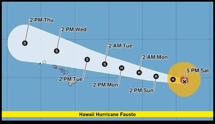

Hurricane Fausto remains one of the most closely monitored weather systems in the Central Pacific, with forecasters continuing to evaluate its movement toward the Hawaiian Islands. Although the cyclone has weakened from its earlier peak, officials are still urging residents and visitors to pay close attention to changing weather conditions over the coming days. Even a weakening tropical cyclone can generate dangerous surf, strong ocean currents, heavy rain, and gusty winds across large areas, making preparation important regardless of whether the center of the storm reaches land.
As the latest forecasts continue to evolve, the overall expectation is that the system will lose additional strength before making its closest pass to Hawaii. However, the exact impacts will depend on the storm’s final track, speed, and interaction with local weather conditions.
A Closely Watched Storm in the Central Pacific
The 2026 Central Pacific hurricane season has already produced notable tropical activity, and Hurricane Fausto has attracted significant public attention because of its projected path toward the Hawaiian Islands.
The storm originally developed over the warm waters of the eastern Pacific Ocean, where favorable environmental conditions allowed it to organize and strengthen into a hurricane. As it continued traveling westward, it entered the Central Pacific basin while remaining under constant observation by meteorologists.
Unlike many Pacific hurricanes that remain far from populated areas, Fausto’s forecast track places it close enough to Hawaii that its outer effects are expected to be felt across parts of the island chain. Although the center is currently forecast to stay offshore, tropical cyclones often produce hazardous conditions hundreds of miles away from their circulation center.
For that reason, weather officials continue emphasizing preparedness rather than focusing only on whether the eye of the storm makes a direct approach.
Current Strength and Movement
According to the latest official forecast, Hurricane Fausto has weakened since reaching its maximum intensity earlier in its life cycle.
The storm previously strengthened into a Category 2 hurricane before beginning a gradual weakening trend. Environmental factors such as increasing wind shear and slightly less favorable atmospheric conditions are expected to continue reducing its intensity over the next several days.
Current forecasts indicate:
- The cyclone is moving generally westward across the Central Pacific.
- Maximum sustained winds have decreased from their earlier peak.
- Continued weakening is expected before the system reaches its closest point to Hawaii.
- The storm could weaken to tropical storm strength later in the forecast period.
Although this weakening trend is encouraging, meteorologists caution that the storm still has the potential to produce dangerous weather across the islands.
Forecast Track Remains Under Close Observation
Forecast models continue showing the storm moving westward while passing north of much of the Hawaiian Island chain.
At this time, the projected path suggests that the center of the cyclone should remain offshore. However, weather forecasts are continually updated, and relatively small changes in track can produce significant differences in local weather conditions.
Even a shift of several dozen miles could influence:
- Rainfall distribution
- Wind intensity
- Surf conditions
- Coastal impacts
- Marine hazards
Because of these uncertainties, residents are encouraged to continue monitoring forecast updates rather than relying on earlier projections.
Large Ocean Swells Could Be the Greatest Concern
One of the most significant impacts expected from Hurricane Fausto involves the ocean rather than the land.
As the cyclone moves across the Pacific, it generates long-period swells capable of traveling hundreds of miles before reaching Hawaii’s coastline. These swells can arrive well before the center of the storm reaches its closest point to the islands.
As surf builds, coastal areas may experience:
- Powerful breaking waves
- Dangerous shore break
- Strong rip currents
- High surf along exposed coastlines
- Beach erosion in vulnerable locations
- Hazardous conditions for swimmers and surfers
Even experienced ocean users are advised to exercise caution because long-period swells can create unpredictable wave patterns.
Conditions may become especially dangerous near rocky shorelines, harbor entrances, and beaches exposed to incoming swells.
Heavy Rain Could Develop in Localized Areas
Although widespread flooding is not currently expected across all islands, periods of moderate to heavy rainfall remain possible as tropical moisture associated with Fausto moves nearby.
Rainfall amounts often vary considerably in Hawaii because of the islands’ mountainous terrain. Moist air forced upward by higher elevations frequently produces enhanced rainfall on windward slopes while leaving nearby areas considerably drier.
Possible rainfall impacts include:
- Localized flash flooding
- Water-covered roadways
- Reduced visibility
- Brief travel disruptions
- Overflowing drainage systems
- Rising water levels in streams and creeks
Communities in flood-prone locations should remain aware of changing weather conditions throughout the event.
Wind Conditions May Differ Across the Islands
Current forecasts indicate that destructive hurricane-force winds are becoming less likely because of the expected weakening trend.
However, gusty winds can still produce localized problems, especially in elevated terrain and exposed coastal areas.
Residents may encounter:
- Strong wind gusts
- Broken tree limbs
- Isolated power interruptions
- Blowing debris
- Difficult driving conditions
- Temporary disruptions to outdoor activities
The strongest winds are not always located near the center of a tropical cyclone. Rain bands extending far from the storm can also produce brief periods of stronger gusts.
READ MORE- Hawaii Hurricane Kiko Update: Weakened Storm Still Brings Dangerous Surf to the Islands
Hazardous Conditions for Mariners
Boaters and commercial marine operators are expected to experience some of the most challenging conditions associated with Hurricane Fausto.
Large swells, rough seas, and strong currents can make navigation dangerous, even if skies appear relatively calm.
Marine hazards may include:
- Rough ocean conditions
- Large swells
- Hazardous harbor entrances
- Reduced visibility during rain showers
- Dangerous conditions for smaller vessels
Recreational boaters should closely monitor marine forecasts before heading onto the water.
Travel Could Experience Temporary Disruptions
Storms passing near Hawaii often affect transportation schedules even when they remain offshore.
Depending on local weather conditions, travelers could encounter:
- Flight delays
- Changes to airline schedules
- Ferry service interruptions
- Temporary harbor restrictions
- Beach closures
- Suspension of some outdoor tours
- Hiking trail closures because of unsafe conditions
Visitors are encouraged to stay in contact with airlines, hotels, and tour operators throughout the week for updated information.
Emergency Officials Encourage Preparedness
State and county emergency management agencies continue encouraging residents to prepare before weather conditions deteriorate.
Simple preparation steps can help reduce the impact of changing weather.
Recommended actions include:
- Charging mobile devices and backup batteries.
- Reviewing family emergency plans.
- Securing outdoor furniture and loose objects.
- Stocking enough food and drinking water for several days.
- Keeping flashlights and emergency supplies readily available.
- Monitoring official weather alerts regularly.
- Avoiding unnecessary ocean activities once large surf arrives.
Preparing early allows families to focus on safety instead of making last-minute arrangements.
Why Storms Near Hawaii Require Special Attention
Hawaii occupies a unique position in the Pacific Ocean, and tropical cyclones approaching the islands behave differently than storms affecting many mainland locations.
The islands’ volcanic mountains significantly influence local weather patterns. Rainfall can vary dramatically over relatively short distances, while strong winds may become enhanced over ridges and valleys.
Even when hurricanes weaken before arriving, they may still produce:
- Dangerous surf
- Coastal flooding
- Flash flooding
- Landslides in steep terrain
- Power outages
- Transportation disruptions
- Marine hazards
For these reasons, emergency planners carefully monitor every tropical cyclone approaching the region, regardless of projected intensity.
Public Interest Continues to Grow
Interest in Hurricane Fausto has increased as residents and visitors seek reliable information regarding possible impacts.
Hotels, businesses, airlines, schools, and local governments are all reviewing preparedness procedures while awaiting updated forecasts.
Many residents remember previous tropical systems that weakened before reaching Hawaii but still generated dangerous surf, flooding, and isolated infrastructure damage. These experiences reinforce the importance of staying informed throughout the event.
Officials continue reminding the public that weather forecasts improve as storms move closer, making regular updates especially valuable.
What to Expect Over the Coming Days
The current outlook suggests that the storm will continue moving westward while gradually weakening.
If this forecast remains on track, Hawaii is expected to experience the greatest impacts from:
- Large ocean swells
- Dangerous surf
- Strong rip currents
- Periods of heavy rain
- Gusty winds
- Hazardous marine conditions
Conditions should gradually improve after the system moves farther west into the Central Pacific.
Nevertheless, tropical weather systems can change in both intensity and track, meaning residents should continue monitoring official forecasts until the storm is well past the islands.
Looking Ahead
Hurricane season in the Central Pacific continues through November, meaning additional tropical systems remain possible during the coming months. While many storms weaken before approaching Hawaii, each system presents its own unique forecast challenges.
Hurricane Fausto serves as another reminder that preparation should begin before severe weather arrives. By staying informed, following local guidance, and taking sensible precautions, residents and visitors can reduce the risks associated with tropical weather while remaining ready for any forecast changes.
Stay tuned for the latest updates on Hurricane Fausto, and feel free to share your thoughts or local weather conditions in the comments below.