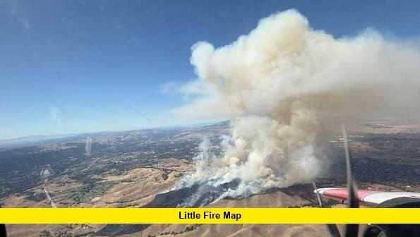

Search interest in the little fire map has spiked as a fast-moving wildfire broke out in the hills between Pleasanton and Sunol in Alameda County, California, prompting evacuation orders and a large multi-agency firefighting response. Residents across the East Bay are turning to live tracking tools to follow the fire’s perimeter, containment status, and evacuation zones in real time, and this article breaks down what is currently known, how the fire has progressed, and where to find reliable, up-to-date mapping information.
What Is Happening With the Little Fire
The wildfire, officially named the Little Fire by Cal Fire, ignited on Tuesday, July 21, 2026, in the area of Little Valley Road and Hubbard Lane, south of Pleasanton and southeast of the Callippe Preserve Golf Course. The blaze was first reported in the early-to-mid afternoon and grew with alarming speed, moving from an initial 50 acres to roughly 150 acres within about half an hour, then surging past 700 acres and eventually to 950 acres by early evening. Containment remained at zero percent for much of the initial response before crews reported early progress, reaching around 10 percent containment as of that evening’s updates.
The fire is burning in the rural hills and open space between Pleasanton, Sunol, and Livermore rather than within any downtown area, though the smoke plume has been visible for miles across the East Bay. Firefighters have noted that the terrain, hot weather, and limited access to the head of the fire have made suppression efforts particularly difficult. At least one firefighter has been injured during the response, according to Cal Fire’s incident updates, though further details on the extent of the injury have not been released.
How the Little Fire Started and Spread
Cal Fire’s SCU Unit responded jointly with the Alameda County Fire Department and the Livermore-Pleasanton Fire Department shortly after the fire was first spotted. The cause of the Little Fire remains under investigation, and no official determination has been announced. As with most fast-developing wildfires, early reports on start time varied slightly between agencies, with some placing ignition around 2:41 p.m. and others closer to 3:39 p.m., but all sources agree the fire grew unusually quickly once it took hold in dry brush and grass fuels.
Within the first hour, the fire’s rapid rate of spread forced officials to escalate their response, calling in additional air tankers, helicopters, dozers, and ground crews. The Oakland Fire Department also sent a mutual aid contingent of roughly 25 firefighters to assist. Firefighting aircraft have been working to slow the fire’s advance from above while ground crews focus on building and reinforcing containment lines around the perimeter.
Evacuation Zones and Affected Areas
As the Little Fire expanded, evacuation orders were issued and broadened several times throughout the afternoon and evening. The first evacuation order covered Zone ALC-072, the area north of State Route 84/Vallecitos Road, east of Interstate 680, and south of the Callippe Golf Course in Sunol. As the fire grew, the order was expanded to include:
- Zone PLS-103, covering areas east of the golf course
- Zones PLS-081 and PLS-080, west of Isabel Avenue, including the Ruby Hill gated community on the eastern edge of Pleasanton
- Zones PLS-082 and PLS-079, which were upgraded from evacuation warnings to full evacuation orders
The Pleasanton Senior Center, located at 5353 Sunol Boulevard, was opened as an evacuation support center for residents displaced by the fire. Officials have urged residents in and near the affected zones to monitor official channels rather than rely on outdated screenshots or unverified social media posts, since a live little fire map can shift quickly as new perimeter data comes in.
How to Read a Live Wildfire Map
For residents trying to make sense of a live little fire map, a few key elements typically appear on official tracking tools. The fire perimeter shows the current estimated boundary of the burn area, though this can lag slightly behind real conditions during periods of rapid growth. Evacuation zones are usually color-coded, distinguishing between areas under a mandatory evacuation order and those under an evacuation warning, meaning residents should be prepared to leave but are not yet required to do so.
Most mapping platforms also display containment lines, which indicate where firefighters have established control over the fire’s edge, along with markers for active aircraft operations, road closures, and shelter or evacuation center locations. Because conditions around an active wildfire can change within minutes, officials recommend checking multiple official sources, including Cal Fire’s incident page and county-level emergency notification systems, rather than depending on a single map or app.
Air Quality and Public Safety Concerns
Smoke from the Little Fire has affected air quality across parts of the East Bay, and the Bay Area Air District has monitored conditions closely as the fire has grown. Pollution levels were not expected to exceed national 24-hour health standards during the initial phase of the fire, and a Spare the Air alert was not issued, though officials have still urged residents in smoke-affected areas to stay alert to air quality warnings and limit outdoor activity if visibility or smell of smoke becomes noticeable.
Residents near the fire zone, particularly those with respiratory conditions, children, or older family members, have been advised to keep windows closed and avoid strenuous outdoor activity until conditions improve. Local health officials continue to monitor smoke dispersal patterns, which can shift depending on wind direction and intensity.
Why This Fire Is Drawing So Much Attention
Wildfires in populated areas near Pleasanton, Sunol, and Livermore tend to draw significant public attention because of how close the fire lines can come to residential neighborhoods, including higher-profile communities like Ruby Hill. The speed at which the Little Fire grew, jumping from roughly 50 acres to nearly 950 acres in a matter of hours, is part of what has driven so many residents to search for real-time mapping tools rather than wait for scheduled news updates.
This is not the first fire to bear the “Little Fire” name in the region. A smaller, unrelated incident also called the Little Fire burned near the same general area, at State Route 84 and Little Valley Road in Sunol, back in October 2019, and was fully contained after burning about 12 acres. A separate, larger Little Fire also burned in Kern County near Lake Isabella in August and September of 2025, scorching more than 2,500 acres before being fully contained. These past incidents are unrelated to the current 2026 fire but may cause some confusion for anyone searching general wildfire archives, since fire names are sometimes reused across different years and locations.
Latest Developments and What to Expect
As of the most recent updates, containment on the Little Fire had begun to increase from its initial zero percent, though firefighters continue to describe the situation as active and evolving. Officials have emphasized that containment percentages and acreage estimates may be revised as crews get better access to remote sections of the fire line and as mapping data is refined using aerial and satellite imagery.
Residents in or near the evacuation zones should continue to rely on official emergency alert systems and Cal Fire’s incident updates for the most accurate, moment-to-moment information. Road closures in the vicinity of Vallecitos Road and surrounding routes may also continue to shift as firefighting operations proceed, so travelers in the area should plan for possible detours.
Final Thoughts
The Little Fire burning between Pleasanton and Sunol has quickly become one of the most closely watched wildfire incidents in the East Bay this week, driven by its rapid growth, the evacuation of several residential zones, and visible smoke across the region. While firefighting crews have made early progress on containment, the situation remains dynamic, and residents are encouraged to rely on verified, official mapping sources rather than secondhand reports. As with any active wildfire, conditions can change quickly depending on weather, terrain, and resource availability, so checking a reliable little fire map regularly remains the best way to stay informed and safe.
Stay tuned for further updates on the Little Fire, and feel free to share your thoughts or local observations in the comments below.