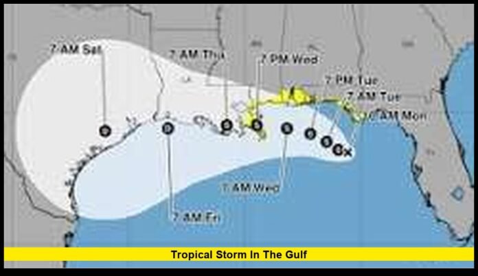

The tropical storm in the gulf continues to draw close attention across the U.S. Gulf Coast as Tropical Storm Bertha moves slowly over the Gulf of Mexico. Weather officials are closely tracking the system because its slow pace increases the chance of prolonged heavy rainfall, coastal flooding, gusty winds, and rough marine conditions. Although Bertha is not among the strongest storms to develop this hurricane season, its expected impacts could still disrupt travel, daily life, and coastal communities over several days.
Residents from the Florida Panhandle to parts of Louisiana are being urged to stay weather-aware as forecasts continue to evolve. Small changes in the storm’s path could shift where the heaviest rain and strongest winds occur, making it important for everyone along the northern Gulf Coast to monitor local conditions.
Current Status of Tropical Storm Bertha
Bertha remains a well-organized tropical storm over the northeastern Gulf of Mexico. Forecasters continue to monitor its gradual strengthening while keeping a close eye on its movement toward the northern Gulf Coast.
The storm has maintained tropical-storm-force winds and continues to move at a relatively slow speed. Unlike faster-moving systems that pass through an area within several hours, Bertha is expected to linger longer, allowing rain bands to repeatedly affect many of the same locations.
That slower movement is one of the biggest reasons weather experts remain concerned despite the storm’s moderate wind speeds.
Where the Storm Is Expected to Travel
Forecast guidance indicates that Bertha will continue tracking generally northwest before approaching the northern Gulf Coast.
Areas likely to experience the greatest impacts include:
- Florida Panhandle
- Coastal Alabama
- Mississippi Gulf Coast
- Southeastern Louisiana
While the overall forecast has remained fairly consistent, even a shift of several miles could change which communities receive the highest rainfall totals or experience stronger winds.
Communities well inland should also stay alert since tropical systems often continue producing heavy rain long after moving away from the coastline.
Why This Storm Is Receiving So Much Attention
Not every tropical storm receives widespread attention, but Bertha presents several characteristics that increase concern.
The storm is moving slowly across very warm Gulf waters while interacting with a favorable moisture-rich atmosphere. Even without becoming a hurricane, these conditions allow large amounts of tropical moisture to move inland.
Instead of wind being the primary hazard, excessive rainfall is expected to become the greatest threat for many communities.
Flooding has historically caused more fatalities than wind during many tropical systems, particularly when roads become submerged unexpectedly.
Heavy Rainfall Could Become the Biggest Hazard
The greatest danger associated with Bertha is expected to come from prolonged rainfall.
Many coastal locations could receive several inches of rain over a relatively short period. In locations where rain bands repeatedly pass across the same communities, totals may become significantly higher.
Heavy rainfall may lead to:
- Flash flooding
- Flooded neighborhoods
- Water-covered highways
- Overflowing drainage systems
- Rising creeks and streams
Urban areas are especially vulnerable because pavement prevents water from soaking into the ground quickly.
Drivers should remember that floodwaters may hide washed-out pavement or debris beneath the surface.
Flooding May Continue After the Storm Moves Inland
One important feature of tropical storms is that flooding does not necessarily end once the center moves ashore.
Rain bands can continue producing heavy downpours for many hours after landfall.
Communities located dozens of miles inland may still experience:
- Flash flooding
- River flooding
- Road closures
- Local evacuations
Because rivers respond more slowly than streets, some waterways may continue rising even after rainfall begins decreasing.
Residents living near rivers or low-lying areas should continue monitoring conditions until floodwaters completely recede.
Storm Surge Remains a Coastal Threat
Storm surge is another major concern for communities located directly along the coast.
Strong onshore winds can push seawater inland, flooding normally dry areas around bays, inlets, beaches, and coastal roads.
Even a tropical storm can generate dangerous storm surge if winds continue blowing toward the shoreline over many hours.
Low-lying neighborhoods may experience:
- Saltwater flooding
- Beach erosion
- Flooded marinas
- Water-covered coastal highways
Storm surge often arrives before the center of the storm reaches land, making early preparation especially important.
Wind Could Still Cause Local Damage
Although flooding receives much of the attention, tropical-storm-force winds can still create hazardous conditions.
Strong wind gusts may:
- Snap tree branches
- Damage weaker structures
- Blow loose outdoor objects
- Cause scattered power outages
- Make driving difficult on exposed bridges
Power restoration crews often prepare in advance so repairs can begin quickly once conditions become safe.
Residents should secure outdoor furniture, trash containers, decorations, and other loose items before winds strengthen.
Risk of Isolated Tornadoes
Tropical storms frequently produce brief tornadoes, especially within outer rain bands.
These tornadoes often develop quickly and may occur with little advance notice.
The highest risk generally exists across:
- Florida Panhandle
- Southern Alabama
- Nearby inland counties
Because tornado warnings may be issued rapidly, residents should keep emergency alerts enabled on their mobile devices.
Having multiple methods of receiving weather warnings remains one of the simplest ways to improve safety during tropical weather.
Marine Conditions Are Becoming Increasingly Dangerous
Boaters and commercial vessels across the Gulf of Mexico are already encountering deteriorating conditions.
As Bertha approaches the coastline, mariners should expect:
- Building seas
- Stronger winds
- Reduced visibility
- Dangerous waves
- Hazardous navigation
Small recreational boats should remain in port until conditions improve.
Beachgoers should also expect dangerous rip currents capable of pulling swimmers away from shore even before the storm arrives.
Travel Disruptions May Increase
Heavy rainfall and gusty winds could affect transportation throughout portions of the Gulf Coast.
Travel impacts may include:
- Airport delays
- Flight cancellations
- Highway flooding
- Bridge restrictions
- Reduced visibility during heavy rain
Motorists planning long-distance travel should allow additional time and remain prepared for changing road conditions.
Never attempt to drive around barricades placed across flooded roads.
Read More – Tropical Storm Bertha Hurricane: Latest Forecast, Expected Impacts, and What to Watch Along the Gulf Coast
Offshore Energy Operations
The Gulf of Mexico remains one of the nation’s most important offshore energy production regions.
As tropical systems approach, companies routinely implement precautionary safety measures.
These may include:
- Evacuating nonessential personnel
- Temporarily reducing production
- Securing offshore platforms
- Monitoring changing sea conditions
These actions are designed to protect workers while minimizing potential damage to offshore facilities.
Operations typically resume once weather conditions become safe.
Emergency Preparations Along the Coast
Communities across the northern Gulf Coast have already begun preparing for possible impacts.
Emergency management officials encourage residents to complete preparations before weather conditions deteriorate.
Helpful preparation steps include:
- Charging electronic devices
- Refilling prescription medications
- Preparing emergency kits
- Securing outdoor belongings
- Reviewing family emergency plans
- Fueling vehicles
- Keeping flashlights and batteries available
Taking these simple precautions early reduces the need for unnecessary travel once the storm begins affecting an area.
How Slow-Moving Tropical Storms Differ
The speed of a tropical system often plays a major role in determining its overall impact.
Fast-moving storms usually spread rainfall over a larger area while limiting how long any single community experiences heavy rain.
Slow-moving systems behave differently.
Because they remain over the same region for an extended period, rain continues falling over identical locations for hours, increasing the likelihood of flooding.
This characteristic makes Bertha especially noteworthy despite its moderate strength.
Communities That Should Remain Alert
Although coastal counties face the greatest immediate threats, inland communities should not assume they are free from danger.
Residents should continue monitoring local weather updates if they live in:
- Coastal Florida
- Inland Florida Panhandle
- Southern Alabama
- Mississippi
- Southeastern Louisiana
Rainfall can extend well away from the storm’s center, creating hazardous conditions far inland.
Hurricane Season Continues
Bertha also serves as another reminder that the Atlantic hurricane season remains active.
Conditions across the Gulf of Mexico continue to support tropical development during the summer months.
Warm ocean temperatures provide energy that allows tropical disturbances to organize quickly.
Even after Bertha eventually weakens, additional tropical systems may still develop later in the season.
For that reason, emergency officials encourage Gulf Coast residents to keep hurricane supplies available throughout the season rather than preparing only when storms approach.
What Residents Should Watch Over the Next Several Days
Forecast updates will continue as meteorologists analyze new satellite imagery, radar observations, aircraft reconnaissance data, and computer forecast models.
The most important changes to monitor include:
- Any increase in wind intensity
- Changes in the projected track
- Updated rainfall forecasts
- Flood warnings
- Storm surge forecasts
- Local evacuation notices
Weather conditions can change quickly, especially near landfall.
Checking updated forecasts several times each day remains the best way to stay informed.
How Local Communities Could Be Affected
Beyond weather itself, Bertha could temporarily affect daily life across portions of the Gulf Coast.
Possible community impacts include:
- School schedule changes
- Delayed public events
- Temporary business closures
- Ferry service interruptions
- Beach access restrictions
- Localized utility outages
Many of these impacts depend on the exact track and rainfall distribution, which will become clearer as the storm approaches land.
Looking Ahead
While Bertha is not currently among the strongest tropical systems of recent years, its slow movement makes it a storm that deserves careful attention.
Heavy rainfall, localized flooding, rough surf, coastal inundation, and scattered power outages remain the primary concerns for communities along the northern Gulf Coast.
Residents should continue preparing for changing conditions while following local emergency guidance as new forecasts become available.
Storms of this nature often demonstrate that flooding—not extreme wind—is frequently the greatest hazard. Staying prepared before weather conditions worsen can help reduce risks for families, businesses, and travelers across the region.
What are conditions like in your area? Share your thoughts in the comments and stay informed as new updates continue to unfold.