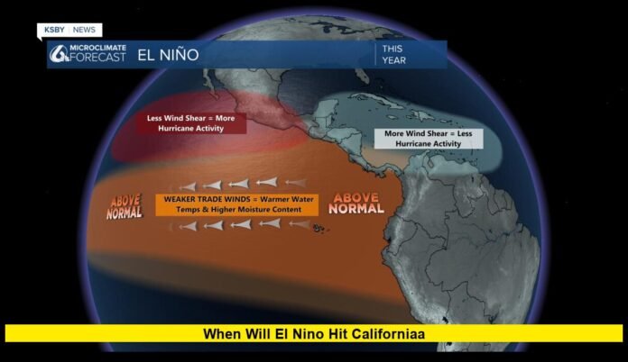

When will El Niño hit California? The latest 2026 outlook shows that the climate pattern is already established in the tropical Pacific and is expected to strengthen substantially through the fall, with its most important effects on California developing from late fall into winter. Forecasters are watching the event closely because the 2026–27 El Niño is projected to become exceptionally strong, potentially placing it among the most powerful events observed in modern records.
For California, however, there is no single day when El Niño suddenly arrives. The phenomenon develops thousands of miles away in the tropical Pacific, and its influence on California weather builds as changes in ocean temperatures, atmospheric circulation and the Pacific jet stream interact.
The biggest period for Californians to watch is December 2026 through March 2027, when the developing pattern could contribute to wetter conditions, stronger Pacific storms, atmospheric rivers, coastal flooding and significant changes in Sierra Nevada precipitation.
El Niño Is Already Underway
El Niño is not a future event waiting to reach California. It is already present across the tropical Pacific.
The latest climate monitoring shows unusually warm sea-surface temperatures across the central and eastern equatorial Pacific. The warming has strengthened considerably during recent months, while atmospheric conditions have also become increasingly consistent with a mature El Niño pattern.
Forecast models indicate that the event should continue strengthening during the remainder of 2026. The strongest phase is expected around late fall or early winter, meaning California’s most noticeable weather response could develop after the tropical Pacific reaches peak intensity.
This distinction matters when discussing the timing of California impacts.
A person in Los Angeles, San Diego, Sacramento or San Francisco may not notice a dramatic change simply because El Niño has been officially declared. Instead, the influence appears through changes in storm tracks and the probability of particular types of weather over weeks and months.
When Could California Feel the Strongest Effects?
The strongest California impacts are expected during the December 2026 through February 2027 period, with effects potentially continuing into March and beyond.
California’s rainy season naturally becomes more active during winter, so El Niño can amplify weather patterns that are already occurring during this part of the year.
The developing event is particularly important because forecasts show an unusually strong tropical Pacific signal. The combination of very warm water and changes in the atmospheric circulation could help strengthen the subtropical jet stream and shift the Pacific storm track toward California.
That does not mean every storm will move directly into the state.
Instead, El Niño changes the overall odds of different weather patterns. Some weeks could remain relatively dry while another period produces several powerful storms in rapid succession.
September and October 2026: The Pattern Strengthens
The fall of 2026 represents the transition period.
During September and October, El Niño is expected to continue strengthening in the tropical Pacific. California’s weather can still fluctuate considerably during this time, and individual storms should not automatically be attributed to El Niño.
The larger signal becomes more important as the Pacific circulation adjusts.
By late October and November, forecasters should have a clearer picture of how the tropical warming is influencing the jet stream and storm track over the North Pacific.
This is also the period when California residents, especially those in flood-prone and coastal areas, should begin paying closer attention to winter preparedness.
November 2026: A Key Transition Month
November could provide some of the first meaningful clues about how strongly California will respond.
The state’s northern and southern regions do not always respond to El Niño in exactly the same way. Southern California often has a stronger connection to El Niño-related winter precipitation, while Northern California’s outcome can depend heavily on the exact position of the storm track.
By November, forecasters can begin comparing actual atmospheric behavior with the seasonal model projections.
If the subtropical jet becomes favorably positioned, the probability of Pacific storms reaching California can increase.
But even then, the exact timing of major rainfall events cannot be determined months in advance.
December 2026: California’s Winter Signal Could Become More Obvious
December is likely to be one of the most important months of the 2026–27 winter.
The California Coastal Commission expects the strengthening El Niño to become particularly influential during the December-to-February period, when coastal communities could experience more frequent or intense storms, heavy rainfall, high waves and erosion concerns.
For Southern California, December could mark the beginning of a much wetter pattern than residents experienced during some recent seasons.
Northern California could also see increased precipitation, although the exact amount will depend on storm positioning.
The Sierra Nevada presents an additional complication because precipitation there could fall as either rain or snow depending on temperatures and snow levels.
January Through March 2027: The Main Window to Watch
January, February and March are likely to be the most important months for assessing the full California impact.
By this point, the El Niño circulation should have had several months to influence the Pacific atmosphere.
Seasonal outlooks currently favor above-normal precipitation across much of California during the winter and early spring.
The strongest signal does not necessarily mean California will experience continuous rainfall.
Instead, the state could see longer wet periods interrupted by dry stretches. A handful of major atmospheric river events could account for a large portion of the season’s total precipitation.
This is why seasonal forecasts should not be interpreted as predictions for individual storms.
Why Does El Niño Bring More Rain to California?
El Niño begins with unusually warm water in the tropical Pacific, but California’s weather response comes largely through atmospheric circulation.
The warmer tropical Pacific can increase thunderstorm activity over certain parts of the ocean. That energy influences the jet stream, which can alter the route followed by Pacific storms.
In many strong El Niño winters, the subtropical jet stream becomes stronger and shifts southward.
When the storm track lines up with California, Pacific moisture can be transported directly toward the West Coast.
This setup can increase the likelihood of:
- Heavy rainfall
- Atmospheric rivers
- Strong Pacific storms
- Large waves
- Coastal flooding
- Mudslides and debris flows
- Sierra precipitation
- Short-duration extreme rainfall
The actual outcome still depends on other atmospheric patterns operating at the same time.
Southern California May See a Stronger Rainfall Signal
Southern California traditionally has one of the clearest relationships with El Niño.
Los Angeles, Orange County, San Diego and nearby areas can experience increased winter precipitation during strong El Niño events.
This does not guarantee that every Southern California location will have a wet winter.
Rainfall can vary dramatically from one storm to another, and local terrain can produce major differences in precipitation.
One major concern is that intense rainfall can overwhelm drainage systems, particularly when several storms occur close together.
Burn-scar areas can also face elevated risks of debris flows and mudslides during intense winter storms.
What About Northern California?
Northern California could also receive above-average precipitation during the 2026–27 winter, but the relationship with El Niño is more complicated.
The position of the Pacific jet stream will be crucial.
If storms track farther north, Northern California could miss some of the heaviest rainfall while areas farther south receive more precipitation.
If the storm track shifts northward, Northern California could receive substantial rain and mountain snow.
That uncertainty is one reason seasonal forecasts describe probabilities rather than guarantees.
Could the Sierra Nevada Get More Snow?
The answer depends on temperature as much as precipitation.
A wetter winter does not automatically produce a larger Sierra Nevada snowpack.
If storms are unusually warm, precipitation could fall as rain at elevations that normally receive snow. If colder conditions accompany the storms, much more of that moisture could accumulate as mountain snow.
The distinction is important for California’s water supply.
Snowpack acts as a natural reservoir, storing winter precipitation and releasing water during the warmer months.
For that reason, California water managers will be watching both total precipitation and snow-water equivalent throughout the winter.
Could El Niño End California’s Water Problems?
A wet winter could improve water conditions, but it would not automatically solve every water-supply challenge.
California’s water picture depends on reservoirs, groundwater, snowpack, soil moisture, agricultural demand and temperatures.
A winter with heavy rainfall can provide immediate benefits to reservoirs and rivers, but rain does not always produce the same long-term water benefit as snow.
There is also a major difference between statewide precipitation and local water conditions.
One part of the state can experience flooding while another remains relatively dry.
Therefore, the eventual water-supply impact of the 2026–27 El Niño will depend on where precipitation falls, when it falls and whether it arrives as rain or snow.
Flooding and Coastal Risks Could Increase
A powerful El Niño can create more opportunities for major Pacific storms to affect California.
That means residents should pay attention not only to rainfall totals but also to storm intensity.
Potential hazards include:
Urban Flooding
Heavy rainfall can overwhelm drainage systems in densely developed areas.
Flash Flooding
Intense rainfall can produce rapid rises in streams and waterways.
Mudslides and Debris Flows
Steep terrain and areas affected by wildfires can become particularly vulnerable during major storms.
Coastal Flooding
High tides combined with large waves and storm conditions can increase coastal flooding concerns.
Beach and Bluff Erosion
Repeated large-wave events can remove sand and weaken coastal bluffs.
High Surf
Powerful Pacific storms can generate dangerous surf conditions even when rainfall inland is limited.
The California Coastal Commission has already highlighted the need for coastal preparedness as the 2026–27 El Niño strengthens.
Why This El Niño Is Different
The current event is receiving significant attention because of its projected strength.
Recent observations show exceptionally warm water across the eastern tropical Pacific, with some sea-surface temperature anomalies exceeding 3 degrees Celsius above average.
Forecast guidance also indicates a substantial possibility of a historically strong event during late 2026 and early 2027.
A strong El Niño does not automatically mean California will experience record rainfall.
The location of the warmest ocean water is extremely important.
When the strongest tropical warming is concentrated farther east, atmospheric circulation can create a storm track more favorable for California precipitation.
Scientists are therefore watching not just how warm the Pacific becomes, but where the warmest water is located.
How Much Rain Could California Get?
It is too early to provide a precise statewide rainfall total for the entire 2026–27 winter.
Seasonal forecasts can identify broad probabilities, but individual storms remain unpredictable months ahead.
Current guidance nevertheless points toward increased odds of above-normal precipitation across California during the core winter season.
The strongest precipitation signal is expected during the traditional December-through-March rainy season.
Some areas could receive considerably more than their seasonal average if several atmospheric rivers make landfall.
Other locations could receive closer-to-normal precipitation despite a generally wet statewide pattern.
This regional variability is normal and should be expected.
Does El Niño Guarantee a Wet Winter?
No.
El Niño is a climate pattern, not a guarantee of a particular weather outcome.
Even during historically strong El Niño events, California can experience dry periods.
Other climate patterns can temporarily strengthen, weaken or redirect the expected El Niño influence.
The Madden-Julian Oscillation, North Pacific atmospheric circulation, sea-surface temperature patterns outside the tropical Pacific and other factors can all affect California weather.
That is why forecasts will continue to change as new observations become available.
What Californians Should Watch in the Coming Months
Residents can track several indicators as winter approaches.
Pacific Ocean Temperatures
Continued warming or cooling will help determine the strength and longevity of the El Niño event.
Jet Stream Position
The jet stream controls where many Pacific storms travel.
Atmospheric River Forecasts
These forecasts become increasingly useful once individual storms are several days away.
Sierra Snow Levels
The elevation of the rain-snow line will be critical for determining California’s winter snowpack.
Reservoir Conditions
Reservoir levels will show how much benefit or pressure the winter precipitation creates for water supplies.
Flood Outlooks
Short-range flood forecasts become much more valuable once specific storm systems are identified.
When will El Niño hit California?
The best way to answer when will El Niño hit California is to recognize that the event is already established in the Pacific, while its strongest weather influence on California is expected to build during late 2026 and become most important through winter 2026–27.
The key window is December 2026 through March 2027.
Southern California may see a particularly strong precipitation signal, while Northern California and the Sierra Nevada will depend more heavily on the exact storm track and temperature pattern.
The latest outlook points toward a wetter winter for much of California, but no seasonal forecast can guarantee a particular rainfall total or predict the exact day a major storm will arrive.
For residents, the most important transition will occur as fall gives way to winter. By then, forecasters should have more information about storm tracks, atmospheric rivers, snow levels and the distribution of California precipitation.
The 2026–27 season could become an important test of how a very strong El Niño translates into real-world California weather. The event is already underway, but the most consequential part of the story is still ahead as winter approaches.