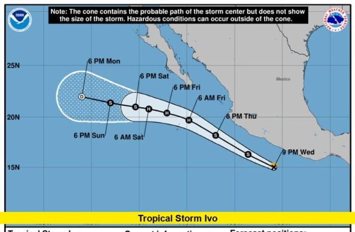
Tropical Storm Ivo, the ninth named storm in the Eastern Pacific this year, is currently impacting parts of Mexico’s southwestern coastline with heavy rain and dangerous surf conditions. As of August 9, 2025, Ivo is situated about 225 miles southwest of the southern tip of Baja California, moving westward at 9 mph with maximum sustained winds near 60 mph. Although the storm is forecast to stay offshore, it is producing significant rainfall and ocean swells that are affecting coastal areas.
Ivo formed on August 6 and has since been tracking northwestward parallel to Mexico’s coast. It is expected to move away from the coast over the next day or two while gradually weakening. However, before it weakens, the storm is likely to bring rainfall ranging from 2 to 4 inches, with some isolated spots receiving up to 6 inches. The Mexican states expected to receive the heaviest rain include Guerrero, Michoacán de Ocampo, Colima, and Jalisco, raising concerns about flash flooding in these regions.
The National Hurricane Center (NHC) reports that tropical-storm-force winds extend outward up to 35 miles from Ivo’s center, but the storm’s relatively small size means wind impacts on land are minimal. Nonetheless, Ivo’s churning ocean swells are creating hazardous surf conditions and life-threatening rip currents along Mexico’s southwestern coast, particularly affecting beaches near the Baja California peninsula. Local residents and visitors are urged to exercise caution when near the water and heed warnings from local weather authorities.
Forecasters also note a possibility that Ivo could briefly intensify to minimal hurricane strength, especially as it remains over warm ocean waters. However, it is expected to weaken by August 10 as it moves into cooler waters and more stable atmospheric conditions. The storm’s path is influenced by a strong ridge over northern Mexico and the southwestern United States, which is steering Ivo westward, away from the mainland, thus avoiding a direct landfall.
Key facts about Tropical Storm Ivo as of August 9, 2025:
- Location: Approximately 225 miles southwest of southern Baja California
- Maximum sustained winds: 60 mph (95 km/h)
- Movement: Westward at 9 mph (15 km/h)
- Rainfall forecast: 2-4 inches, isolated 6 inches in Guerrero, Michoacán, Colima, and Jalisco
- Ocean hazards: Threatening surf and rip currents along the southwestern Mexican coast
- Expected to weaken and become post-tropical by Sunday night, August 10
This is a developing story, but current updates stress that while wind damage is expected to be minimal, flooding and surf hazards pose the greatest threats from Tropical Storm Ivo. Coastal communities should remain vigilant for flash flooding, elevated rivers, and rip currents.
Stay updated on Tropical Storm Ivo and how it may affect weather conditions in the coming days. If you are in affected areas, follow local advisories and exercise caution near the coastline. Feel free to share your experiences or questions about the storm below, and stay safe.
