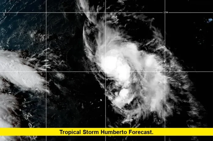
Tropical Storm Humberto forecast updates show the system strengthening in the Atlantic as it tracks away from the Caribbean. Forecasters confirm that Humberto has reached hurricane status, with winds at hurricane-force levels and a growing chance of becoming a major hurricane over the next several days. While Humberto itself is not projected to make direct landfall in the United States, its proximity, potential influence on nearby disturbances, and the risk of secondary effects keep attention high along the East Coast.
Current Status of Humberto
As of this morning, Humberto has been upgraded to a Category 1 hurricane. The storm is located northeast of the northern Leeward Islands, moving slowly toward the northwest. Maximum sustained winds are currently estimated at about 75 miles per hour, and forecasters expect further strengthening through the weekend.
Meteorologists caution that Humberto’s size and slow forward movement mean it will generate large swells across much of the Atlantic. These swells can translate into rough surf and dangerous rip currents for beaches along the U.S. East Coast, even though the storm’s center remains well offshore.
Projected Track and Intensity
The latest forecast models consistently project Humberto curving northward over the next several days. This path keeps the storm largely over open waters of the Atlantic. The system is expected to intensify, with some guidance suggesting Humberto could become a major hurricane, reaching Category 3 strength, by early next week.
For now, Bermuda is closer to the cone of uncertainty than the U.S. mainland, but confidence remains high that the storm will avoid a direct strike on the continental United States. Even so, forecasters remind coastal communities that tropical systems can shift, and large storms often affect areas far from their center through waves, currents, and moisture transport.
Other Tropical Developments to Watch
While Humberto itself appears destined to remain at sea, another tropical disturbance in the western Atlantic raises fresh concerns. A system near Hispaniola and the Turks and Caicos, labeled as a strong tropical wave, is showing signs of organization. This disturbance could develop into Tropical Storm Imelda in the coming days.
If the system strengthens and moves northwestward, the Bahamas and the southeastern U.S. could face more direct impacts by early next week. Heavy rain, localized flooding, gusty winds, and rough seas are possible depending on its eventual track and intensity.
Possible Interaction Between Systems
Because Humberto and the developing wave are in the same region of the Atlantic, forecasters are watching the possibility of a rare interaction called the Fujiwhara Effect. In this situation, two nearby storms can influence each other’s paths, sometimes causing one to change direction or weaken.
At present, most models suggest the storms will remain far enough apart to avoid a major interaction. Still, experts note that the atmosphere is complex, and even small shifts could alter the forecast. For U.S. residents, that means paying close attention to updates in case Humberto indirectly influences the path of the second storm.
Potential Impacts on the U.S.
Although Humberto itself is not expected to make landfall in the United States, its effects will still be felt along parts of the East Coast:
- Coastal Swells and Surf: Large waves generated by Humberto will propagate westward, affecting beaches from Florida up through the Carolinas and possibly farther north.
- Rip Currents: Strong rip currents pose a risk to swimmers and surfers, making beach conditions hazardous even in fair weather.
- Rainfall Indirectly from Other Systems: Depending on the track of the second tropical disturbance, parts of the Southeast may experience heavy rain and localized flooding early next week.
Residents in low-lying coastal zones should be especially aware of conditions if the secondary storm develops closer to shore.
What Forecast Scenarios Show
To summarize, here are the main scenarios outlined by current forecast discussions:
- Baseline Outlook: Humberto strengthens into a major hurricane and curves into the open Atlantic, avoiding direct landfall. The secondary system organizes but mainly skirts offshore.
- Closer U.S. Impact: Humberto remains offshore, but the secondary system tracks toward the Southeast, bringing heavy rain, gusty winds, and possible storm surge.
- Interaction Scenario: Humberto and the secondary system influence one another, leading to shifts in intensity or track that increase forecast uncertainty.
The baseline outlook remains most likely, but scenarios can shift quickly with tropical systems.
Safety and Preparedness Tips
Even in the absence of a direct landfall, U.S. residents should remain cautious. Here are a few reminders from emergency managers:
- Monitor official updates from the National Hurricane Center and local weather offices.
- Stay out of the water if rip current advisories are in effect.
- Secure outdoor items and check drainage systems if heavy rain is forecast for your region.
- Keep a basic emergency kit stocked with essentials such as water, food, flashlights, and first-aid supplies, especially during peak hurricane season.
Looking Ahead
The Atlantic remains active with multiple systems developing as the season reaches its peak. Humberto will continue to strengthen and likely achieve major hurricane status, but the greater near-term concern for the U.S. lies with the tropical disturbance forming closer to the Bahamas.
Forecasters stress that conditions can evolve quickly, so those along the Southeast coast—from Florida through the Carolinas—should stay alert through early next week.
At this stage, the tropical storm Humberto forecast signals limited direct threat to the U.S., but its strength and the presence of nearby systems keep it firmly on the radar. Residents are urged to remain cautious, monitor advisories, and avoid dangerous surf conditions.
Stay safe, stay informed, and share your thoughts or questions in the comments below.
