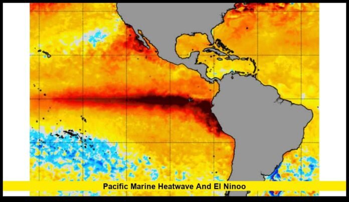

The pacific marine heatwave and el nino combination is emerging as one of the most closely watched climate developments heading into the final months of 2026. El Niño has strengthened rapidly across the tropical Pacific, while unusually warm waters are also affecting parts of the Northeast Pacific, creating a complicated ocean pattern with potential consequences for marine life, fisheries, coastal communities and weather across North America and beyond.
The latest monitoring indicates that this El Niño could become exceptionally strong during the Northern Hemisphere fall and winter. Ocean temperatures in the eastern equatorial Pacific have climbed well above average, while significant heat has also accumulated below the surface. At the same time, separate marine heatwaves are affecting waters along the U.S. West Coast.
Together, these developments have increased attention on what the Pacific may look like through the winter of 2026–27.
El Niño Is Strengthening Rapidly
El Niño is the warm phase of the El Niño-Southern Oscillation, a naturally occurring climate pattern centered on the tropical Pacific Ocean.
Under normal conditions, trade winds push warm surface water westward toward Indonesia and Australia. This allows colder, nutrient-rich water to rise toward the surface in the eastern Pacific near the coasts of Ecuador and Peru.
During El Niño, those trade winds weaken. Warm water that is normally concentrated in the western Pacific shifts eastward, raising sea surface temperatures across the central and eastern equatorial Pacific.
That process is now well underway.
Recent monitoring has shown exceptionally high ocean temperature anomalies in the eastern tropical Pacific. The strengthening warmth is also appearing below the surface, where large amounts of excess heat can provide additional energy for the developing event.
The significance of the subsurface warming is that El Niño does not depend solely on what is happening at the ocean surface. Heat stored deeper in the water can later move upward and help sustain or intensify surface warming.
A Potentially Exceptional El Niño
Forecast confidence has increased considerably as the event has developed.
Current projections indicate a greater than 90% chance of a very strong El Niño during the Northern Hemisphere fall and winter of 2026–27. Some climate models have suggested an event capable of approaching or challenging the strength of the most powerful El Niño episodes observed in the modern record.
That does not mean a record will necessarily be broken.
Long-range climate forecasts can change as new observations become available, and the strength of an El Niño event is measured using several indicators rather than a single ocean temperature reading.
Nevertheless, the signal is unusually strong.
The tropical Pacific is already showing the type of widespread warming and atmospheric response associated with a major El Niño event. If the warming continues through the autumn, the event could become a dominant influence on global weather patterns during the winter.
Marine Heatwaves Add Another Layer
El Niño and marine heatwaves are related, but they are not the same thing.
A marine heatwave is a period when ocean temperatures remain unusually warm compared with the historical conditions normally expected for a particular region and season.
El Niño is a much larger climate phenomenon involving both ocean temperatures and atmospheric circulation across the tropical Pacific.
The distinction matters because some marine heatwaves can develop independently of El Niño.
That is happening along portions of the West Coast.
Researchers have been tracking marine heatwaves in the Northeast Pacific that began before the current El Niño became dominant. These warm-water events have already altered ocean conditions from California northward toward Oregon and Washington.
El Niño may now add another source of ocean warming, potentially changing the location, intensity or duration of marine heatwave conditions.
The Northeast Pacific Remains Unusually Warm
The Northeast Pacific has experienced major episodes of unusual warmth in recent years.
One recent marine heatwave became particularly notable because ocean temperatures across the region reached extraordinary levels. The warmth affected waters along the West Coast and contributed to major ecological changes.
Scientists have continued monitoring newer marine heatwave developments rather than assuming that the end of one event means the broader problem has disappeared.
The persistence of elevated ocean temperatures matters because marine ecosystems respond not only to the intensity of warming but also to how long it lasts.
A short burst of warm water may cause limited disruption. A marine heatwave that persists for months can force species to move, change feeding patterns and alter predator-prey relationships.
Why West Coast Waters Are Important
The waters off California, Oregon and Washington are part of the California Current ecosystem, one of the most biologically productive marine environments in the world.
Cold water rising from deeper layers brings nutrients toward the surface. Those nutrients support plankton, which provide food for small fish and other organisms. Larger fish, seabirds and marine mammals depend on the ecosystem that develops around this productivity.
When the ocean becomes unusually warm, that system can change.
Some cold-water species may move northward or into deeper water. Warm-water species can expand their range into areas where they are less common.
These changes can affect commercial and recreational fishing as well as wildlife that depends on specific prey.
Effects on Salmon Could Be Significant
Salmon are among the species scientists watch closely when Pacific conditions change.
Young salmon entering the ocean depend on an environment where food is available and temperatures remain within suitable limits. Changes in plankton and forage fish can therefore have consequences farther up the food chain.
Marine heatwaves may also alter migration routes and increase competition for food.
El Niño can compound those challenges in the Pacific Northwest because strong events are often associated with warmer and drier conditions across parts of Washington, Oregon and Idaho during winter.
Less mountain snow and more winter precipitation falling as rain can reduce the amount of water stored for later release.
That can become important for rivers and freshwater ecosystems during the following spring and summer.
Marine Mammals Could Face Food-Chain Disruptions
Marine mammals are another important indicator of changing ocean conditions.
Sea lions, seals and other predators depend on the availability and location of fish and squid. When prey populations move because of unusual water temperatures, predators may need to travel farther to feed.
That can affect energy requirements, breeding success and the distribution of animals along the coast.
Seabirds can face similar challenges.
If small fish become less abundant in traditional feeding grounds, birds may have to travel farther from nesting areas. During prolonged heatwaves, these food-chain changes can become widespread.
The effects are therefore not limited to one species.
A temperature change at the surface can ultimately influence organisms throughout an entire marine ecosystem.
Coral Reefs Face a Different Risk
Tropical marine ecosystems face another major threat from persistent warming: coral bleaching.
Corals live in close partnership with microscopic algae that provide much of their energy. When ocean temperatures become unusually high for long enough, corals can expel those algae and become bleached.
Bleached coral is stressed but not necessarily dead. If temperatures return to normal, some reefs can recover.
However, repeated heat exposure reduces the time available for recovery.
Because El Niño pushes unusually warm water into the central and eastern tropical Pacific, scientists will continue watching tropical ecosystems as the event develops.
How the Pacific Can Change U.S. Weather
The Pacific Ocean has an enormous influence on North American weather.
During strong El Niño events, changes in tropical rainfall can alter atmospheric circulation and reshape the jet stream.
The resulting pattern can affect where storms travel and where precipitation is concentrated.
Across parts of the southern United States, El Niño winters have historically been associated with increased precipitation. Meanwhile, parts of the northern tier and Pacific Northwest can experience warmer and drier conditions.
These are tendencies rather than guarantees.
Weather in any individual month depends on numerous factors, including other ocean patterns, atmospheric circulation and shorter-term storms.
Still, a very strong El Niño increases the odds that the Pacific will play an important role in the U.S. winter forecast.
California Could See Major Weather Changes
California is particularly sensitive to changes in Pacific circulation.
Strong El Niño events can increase the likelihood of wetter conditions across parts of the state, especially during the winter season.
However, rainfall totals can vary dramatically from one El Niño event to another.
A strong El Niño does not automatically mean every part of California will experience flooding or a wet winter.
Instead, it shifts the probabilities.
If a powerful Pacific storm track becomes established, California could see periods of heavy rain, mountain snow and coastal impacts. At the same time, individual storms remain difficult to predict months in advance.
This is why seasonal forecasts are best interpreted as changes in risk rather than precise predictions.
The Pacific Northwest May Experience a Different Pattern
The Pacific Northwest often experiences a different El Niño response.
Washington and Oregon can lean warmer and drier during strong El Niño winters, while Alaska can experience different conditions.
A warmer winter can mean more precipitation falling as rain instead of snow in mountain regions.
That distinction is critical for water resources.
Snowpack acts as a natural reservoir. When more winter precipitation arrives as rain, less water remains stored in snow for release during spring and summer.
The resulting impacts can extend into agriculture, hydropower, ecosystems and wildfire risk.
At the same time, strong coastal storms can still occur during El Niño winters, meaning a warmer and drier seasonal average does not eliminate the possibility of individual extreme weather events.
El Niño and the Global Climate System
The effects of the developing event will not stop at North America.
El Niño changes tropical rainfall and atmospheric circulation across the planet.
Some regions can experience increased rainfall and flooding, while others face drought.
The pattern can also influence temperatures, wildfire conditions and agricultural production.
The World Meteorological Organization has warned that developing El Niño conditions can raise the risk of extreme heat, heavy rainfall, drought and marine heatwaves in different parts of the world.
The precise effects depend on the strength and evolution of the event.
Why Scientists Are Watching the Ocean Below the Surface
One of the most important aspects of the current El Niño is the large amount of heat beneath the tropical Pacific.
Surface temperatures receive much of the public attention, but subsurface measurements can provide valuable information about where the event is heading.
Warm water stored below the surface can move upward as atmospheric and oceanic conditions change.
That means subsurface heat can act as an important source of future surface warming.
The current observations show unusually large subsurface temperature anomalies in portions of the equatorial Pacific, reinforcing concerns that the event has considerable energy behind it.
Climate Change Could Make the Background Warmer
El Niño is a natural climate phenomenon, but it is developing within a planet that has warmed significantly over the long term.
Global ocean temperatures have increased as the oceans absorb most of the excess heat associated with greenhouse gas emissions.
That means an El Niño event occurring today begins from a warmer baseline than a similar event many decades ago.
Scientists continue to investigate exactly how climate change will affect the frequency, intensity and characteristics of ENSO events.
Research has produced evidence that some aspects of El Niño behavior may be changing, although important uncertainties remain.
The relationship between long-term warming and individual El Niño events is therefore more complicated than simply saying that climate change creates El Niño.
What to Watch Through Fall and Winter
Several indicators will determine how the Pacific situation develops over the coming months.
Ocean temperatures
Scientists will continue tracking sea surface temperatures throughout the tropical Pacific and along the West Coast.
Subsurface heat
The amount of warm water below the surface will help indicate whether the event has additional fuel for continued development.
Trade winds
Changes in equatorial winds are central to El Niño’s development. Continued weakening or reversal of normal trade-wind patterns can reinforce warming.
Atmospheric pressure
Scientists will monitor pressure patterns to determine whether the atmosphere is responding consistently with a mature El Niño.
Marine ecosystems
Fisheries scientists will track changes in fish distribution, plankton, seabirds and marine mammals as ocean temperatures evolve.
What This Means for the Pacific Marine Heatwave and El Nino Outlook
The pacific marine heatwave and el nino outlook points toward a period of unusually active ocean and climate conditions through the end of 2026 and potentially into early 2027.
The developing El Niño is already strong and is expected to intensify further. At the same time, separate marine heatwaves are affecting sections of the Northeast Pacific, meaning marine ecosystems may face multiple overlapping pressures.
The most important question is not simply how warm the Pacific becomes.
It is how long the unusual warmth persists, where the warmest water develops and how atmospheric circulation responds.
Those factors will determine whether fisheries experience major disruptions, whether marine wildlife changes its distribution and how strongly the Pacific influences U.S. winter weather.
For coastal communities, the coming months will require close attention to both ocean and atmospheric forecasts. The Pacific is a vast system, but changes occurring thousands of miles offshore can eventually reach beaches, fisheries, farms, rivers and communities across the United States.
As fall approaches, scientists will have a clearer picture of whether this El Niño becomes one of the strongest events in the historical record or settles into a less extreme trajectory. Either way, the Pacific will remain one of the most important climate regions to watch heading into winter 2026–27.
What do you think the strengthening El Niño could mean for the Pacific and U.S. weather this winter? Share your thoughts and follow the latest updates as the ocean pattern evolves.