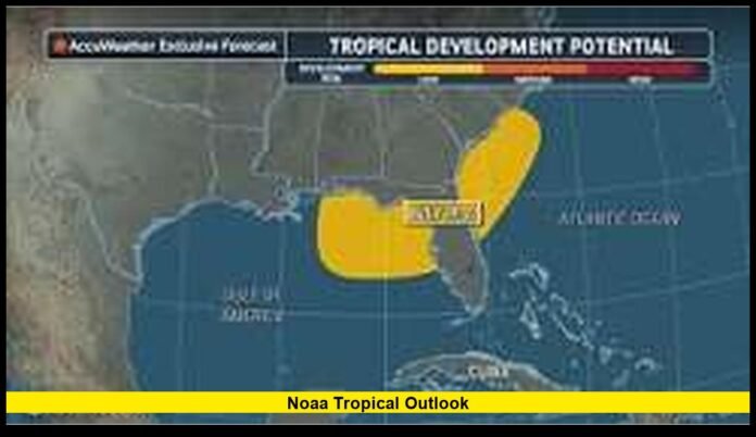

The Atlantic hurricane season is beginning to show more signs of activity, and the NOAA tropical outlook has become one of the most closely watched weather updates for millions of Americans. As of July 19, 2026, forecasters continue to monitor a developing weather system over the northeastern Gulf that has become better organized during the past day. While it has not yet reached tropical cyclone status, environmental conditions remain favorable for additional strengthening, prompting increased attention across the Gulf Coast.
For residents from Texas to Florida, this is a reminder that hurricane season is entering a more active period. Even systems that are still developing can produce heavy rainfall, gusty winds, dangerous surf, and localized flooding. Meteorologists are carefully tracking every change as new satellite images, aircraft observations, and weather models provide a clearer picture of what may happen during the coming days.
Weather Activity Begins to Increase Across the Atlantic Basin
The first half of the Atlantic hurricane season was relatively quiet compared with what is often seen later in the summer. That quieter stretch, however, does not indicate how the remainder of the season will unfold.
Forecasters now see signs that conditions across parts of the Gulf are becoming more supportive of tropical development. Warm ocean waters, sufficient moisture, and gradually improving atmospheric conditions are helping thunderstorms organize around a broad area of low pressure.
Although many tropical disturbances never become named storms, they still deserve close attention because they can bring significant impacts well before reaching official cyclone status.
Developing Gulf System Draws the Most Attention
The primary weather feature under close observation is a broad low-pressure system over the northeastern Gulf of Mexico.
During recent satellite observations, thunderstorms became increasingly concentrated around the center of the disturbance. This improved organization suggests that the system has a better opportunity to strengthen if favorable conditions continue.
Meteorologists continue evaluating several important characteristics, including:
- Organization of thunderstorms
- Surface wind circulation
- Atmospheric pressure
- Moisture surrounding the system
- Wind shear in the upper atmosphere
- Water temperatures beneath the disturbance
Each of these factors helps determine whether the disturbance will continue developing into a tropical depression or tropical storm.
Heavy Rain Could Arrive Before Any Official Storm Forms
One of the biggest misconceptions during hurricane season is that a storm must receive a name before dangerous weather begins.
In reality, developing tropical systems often produce widespread rainfall long before reaching tropical cyclone classification.
Communities near the northern Gulf Coast could experience:
- Periods of heavy rain
- Thunderstorms
- Localized flash flooding
- Ponding on highways
- Reduced visibility for drivers
- Minor flooding in low-lying neighborhoods
These impacts may occur regardless of whether the disturbance officially strengthens into a named storm.
Communities Along the Gulf Coast Stay Alert
Residents across several Gulf Coast states are paying close attention to forecast updates.
Areas most likely to experience changing weather conditions include:
- Florida Panhandle
- Coastal Alabama
- Mississippi Gulf Coast
- Southeastern Louisiana
- Portions of southwestern Georgia
Forecast details may continue changing over the next several days as meteorologists receive additional observational data.
Because tropical weather systems can shift direction unexpectedly, communities outside the current forecast area should continue monitoring updates as well.
Aircraft Missions Help Improve Forecast Accuracy
Forecast models provide valuable guidance, but direct observations remain one of the most important forecasting tools.
Specialized Hurricane Hunter aircraft fly directly into developing tropical systems to collect information unavailable from satellites.
During these missions, crews measure:
- Wind speeds
- Atmospheric pressure
- Air temperature
- Humidity
- Rainfall intensity
- Flight-level winds
- Ocean conditions
This information allows forecasters to better determine whether a closed circulation has formed and how quickly the system may strengthen.
Aircraft observations also improve computer forecast models, making future track and intensity predictions more reliable.
Satellite Technology Watches Every Change
Modern weather satellites continuously monitor tropical disturbances around the clock.
Unlike aircraft missions that occur periodically, satellites provide uninterrupted coverage throughout the life of a weather system.
Meteorologists analyze satellite imagery to observe:
- Thunderstorm growth
- Cloud-top temperatures
- Rotation around the center
- Moisture distribution
- Wind patterns
- Overall storm organization
These observations often reveal subtle improvements or weakening that help shape updated forecasts.
Why Warm Gulf Waters Matter
Ocean temperatures play an important role during hurricane season.
Warm water provides the energy needed for tropical systems to organize and strengthen.
During mid-July, Gulf waters are already warm enough to support tropical development if other atmospheric conditions remain favorable.
However, warm water alone does not guarantee rapid strengthening.
Meteorologists must also consider upper-level winds, moisture availability, atmospheric stability, and existing storm structure before determining how much development is possible.
Rainfall May Become the Greatest Concern
Wind speed often receives the most public attention during tropical weather events, but rainfall frequently creates the greatest number of problems.
Slow-moving systems can repeatedly send rain bands over the same communities.
This can lead to:
- Flash flooding
- Overflowing drainage systems
- Rising creeks
- Water-covered roads
- Temporary business closures
- Travel disruptions
Even moderate rainfall can become dangerous when several inches accumulate within a short period.
Urban areas with extensive pavement are particularly vulnerable because water cannot drain into the ground quickly.
Marine Conditions Could Become Hazardous
The Gulf disturbance may also affect conditions across coastal waters.
Increasing winds and rough seas could create difficult conditions for:
- Recreational boaters
- Commercial fishing vessels
- Charter operations
- Offshore workers
Small craft should closely monitor changing marine forecasts before heading onto open water.
Conditions often deteriorate well before the center of a tropical system approaches the coastline.
Tropical Storm Erin: Atlantic Disturbance Set to Become First Hurricane of 2025 Season
The Atlantic Remains Relatively Quiet Overall
Although attention has shifted toward the Gulf disturbance, the broader Atlantic basin remains fairly calm for this point in the season.
Currently, there are no active Atlantic hurricanes.
Only one developing disturbance is receiving significant attention from meteorologists.
This relatively quiet pattern, however, should not create a false sense of security.
Historically, Atlantic activity increases considerably during August and reaches its seasonal peak in September.
Many of the strongest hurricanes in history formed well after the middle of July.
Eastern Pacific Continues Producing Tropical Systems
While Atlantic residents watch Gulf developments, the eastern Pacific remains more active.
Tropical Storm Elida continues moving over open waters without posing a threat to populated land areas.
The storm serves as another reminder that tropical weather remains active across multiple ocean basins during the summer months.
Different atmospheric patterns often influence activity in the Atlantic and Pacific independently.
How Forecasters Measure Development Chances
Meteorologists evaluate dozens of observations before estimating how likely tropical development has become.
Among the most important factors are:
- Surface circulation
- Persistent thunderstorms
- Warm ocean temperatures
- Low wind shear
- Atmospheric moisture
- Computer model agreement
As confidence increases, forecasts become more specific regarding possible development and future movement.
These updates help emergency managers determine when preparedness activities should begin.
Preparedness Remains the Best Defense
Every hurricane season reinforces one important lesson: preparation should begin before a storm develops.
Residents along the Gulf Coast can use quieter periods to review emergency plans.
Helpful preparedness steps include:
- Checking emergency supply kits
- Charging backup batteries
- Reviewing evacuation routes
- Confirming insurance information
- Securing outdoor furniture
- Preparing important documents
Completing these tasks early reduces stress if watches or warnings are later issued.
Forecasts Continue Changing as New Data Arrives
Weather forecasting combines science, observations, and constantly improving computer models.
Each new advisory incorporates fresh information collected from:
- Weather satellites
- Aircraft reconnaissance
- Ocean buoys
- Coastal radar
- Surface weather stations
Because of these continuous updates, forecast tracks and intensity predictions may change several times each day.
Residents should avoid relying on a single forecast and instead follow the latest official information.
Travel Plans Could Be Affected
Summer vacation season remains busy across Gulf Coast destinations.
Although widespread cancellations are not expected at this stage, travelers should remain aware that tropical weather can affect:
- Airport schedules
- Ferry operations
- Cruise departures
- Beach conditions
- Outdoor events
Checking forecasts before departure can help travelers avoid unexpected disruptions.
Businesses Also Monitor Tropical Weather Closely
Hotels, ports, shipping companies, construction firms, and energy producers all rely heavily on tropical weather forecasts.
Even a weak tropical system can temporarily affect:
- Shipping schedules
- Offshore drilling operations
- Tourism
- Outdoor construction
- Local transportation
Businesses across coastal communities often begin reviewing contingency plans whenever tropical development becomes increasingly likely.
The Weeks Ahead Could Become More Active
July often serves as a transition period before the most active part of hurricane season begins.
Ocean temperatures continue rising throughout late summer, creating increasingly favorable conditions for tropical development.
Although no one can predict exactly how many storms will develop during the coming months, history shows that activity usually increases significantly from August through September.
That is why forecasters encourage everyone living in hurricane-prone regions to remain prepared even during quieter periods.
Why Daily Forecast Updates Matter
Tropical weather can evolve quickly.
A weak disturbance today may become a tropical depression tomorrow if environmental conditions continue improving.
Conversely, systems that appear well organized can weaken unexpectedly if they encounter dry air or stronger upper-level winds.
Daily forecast updates help residents understand these changes and make informed decisions without unnecessary alarm.
Staying informed remains one of the simplest and most effective ways to reduce weather-related risks.
Looking Ahead
The coming days will provide a much clearer picture of how this Gulf disturbance develops. Additional aircraft missions, satellite observations, and forecast model updates will continue refining expectations for its track and strength. While uncertainty remains regarding its ultimate intensity, the possibility of heavy rain and localized flooding means Gulf Coast communities should continue paying close attention to weather updates.
Preparedness does not require panic. It simply means staying aware of changing conditions, understanding local risks, and having a plan ready if weather conditions worsen. As hurricane season gradually becomes more active, keeping an eye on reliable forecast updates remains one of the smartest steps anyone living along the Gulf Coast can take.
What are the weather conditions like in your area? Share your thoughts in the comments and stay informed as new tropical updates continue throughout the hurricane season.