The national hurricane center is actively monitoring several tropical systems across the Atlantic and Pacific basins, marking a busy start to September 2025. With three notable systems currently under watch, forecasters are providing critical updates on potential developments, intensities, and areas at risk.
A tropical wave in the eastern Atlantic, just southwest of the Cabo Verde Islands, has become the primary focus of attention. The system is showing signs of organization, and the national hurricane center has given it a 30 percent chance of formation within the next two days. Over the next week, that probability rises sharply to 70 percent. If the disturbance strengthens further, it could become Tropical Storm Gabrielle, potentially affecting parts of the Caribbean islands in the days ahead.
Hurricane Lorena Develops Off Mexico
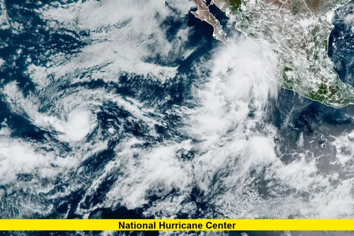
In the eastern Pacific, Hurricane Lorena has officially formed near Baja California. With maximum sustained winds of 75 miles per hour, Lorena has already reached hurricane strength and is forecast to intensify as it tracks northwestward. The national hurricane center has issued tropical storm warnings along portions of the western Mexican coast, with heavy rain and strong winds expected over the coming days.
Forecasters warn that Lorena’s rainfall totals could reach up to 15 inches in some regions. Such rainfall poses a serious risk of flash flooding and mudslides, especially in mountainous terrain. Communities in Baja California and nearby coastal areas are being urged to prepare for possible hazardous conditions, including flooding, landslides, and travel disruptions.
Hurricane Kiko Strengthens in the Pacific
Farther west, Hurricane Kiko remains a strong Category 2 hurricane in the central Pacific. With winds of around 105 miles per hour, Kiko is expected to continue strengthening over the next 48 hours. The system is currently located well east of Hawai‘i, more than 1,700 miles away, and is not considered a direct threat to land at this time.
While the hurricane is expected to remain over open waters, forecasters are keeping a close watch. Shifts in its path could determine whether outer rain bands or swells eventually affect parts of the Hawaiian Islands. For now, maritime interests are advised to monitor updates closely due to the dangerous seas and strong winds surrounding the storm’s core.
Overview of Current Systems
To summarize, the national hurricane center is tracking three active systems:
- Eastern Atlantic Disturbance: 30 percent chance of formation within 48 hours, 70 percent chance over the next week.
- Hurricane Lorena: Sustained winds of 75 mph near Baja California; rainfall totals could reach 15 inches.
- Hurricane Kiko: Category 2 storm with 105 mph winds, located far east of Hawai‘i, with further strengthening expected.
These systems illustrate the growing activity typical of early September, which is historically the peak of the hurricane season. With warm sea surface temperatures and favorable atmospheric conditions, storm development is expected to remain active through the coming weeks.
Seasonal Outlook
The 2025 hurricane season is entering its most intense phase, which spans from late August through October. Meteorologists point out that oceanic and atmospheric patterns are creating a highly conducive environment for storm development. This includes warmer-than-normal sea surface temperatures in the Atlantic, which provide the energy needed for tropical systems to form and strengthen.
The national hurricane center continues to emphasize preparedness as the season progresses. Residents in coastal and island regions are urged to stay informed about forecasts, ensure emergency kits are stocked, and review evacuation plans. Even storms that do not make landfall can cause dangerous rip currents, flooding rains, and high surf in nearby coastal communities.
The Role of the National Hurricane Center
The national hurricane center, based in Miami, plays a vital role in tracking, forecasting, and issuing warnings for tropical storms and hurricanes in the Atlantic and eastern Pacific basins. Using advanced satellite imagery, hurricane-hunter aircraft, and computer modeling, the center provides accurate forecasts that allow communities to prepare ahead of time.
As September progresses, the center will remain on high alert for additional systems forming in both the Atlantic and Pacific. Each advisory, outlook, and update aims to ensure public safety by keeping residents and officials aware of changing conditions.
The next few days will be crucial in determining whether the Atlantic disturbance organizes into Tropical Storm Gabrielle, while Lorena and Kiko continue their paths over the Pacific. With peak hurricane season underway, the national hurricane center stresses vigilance and preparation as tropical activity increases.
Stay safe, stay prepared, and share your thoughts or local updates in the comments below.
Disclaimer
This article is based on the latest public updates from the National Hurricane Center and related meteorological agencies as of September 3, 2025. Forecasts may change as new data becomes available. Readers in potentially affected areas should always follow official advisories and instructions from the National Hurricane Center, local authorities, and emergency management officials.
