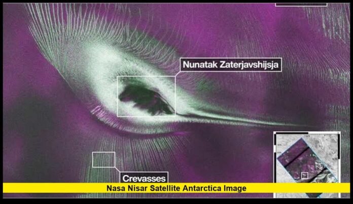

The release of the latest nasa nisar satellite antarctica images has given scientists and space enthusiasts an extraordinary new perspective on one of the most remote places on Earth. Produced by the joint NASA-ISRO Synthetic Aperture Radar (NISAR) mission, these radar images reveal intricate patterns within Antarctica’s vast ice sheet, highlighting glacier movement, hidden crevasses, and mountainous terrain that are difficult—or sometimes impossible—to capture using conventional satellite photography. One of the mission’s most talked-about visuals even resembles a colorful hummingbird, demonstrating how advanced radar technology can transform scientific observations into striking imagery while providing valuable data for climate research.
Key Points Summary
╔════════════════════════════════════════════════════════════════════╗
║ – NASA and ISRO have released remarkable new radar images of Antarctica through the NISAR mission. ║
║ – A mountain surrounded by flowing ice creates a natural formation resembling a colorful hummingbird. ║
║ – Dual-frequency radar enables observations through clouds, darkness, and harsh weather conditions. ║
║ – Scientists are using the mission to monitor glaciers, ice sheets, earthquakes, forests, and wetlands worldwide. ║
║ – NISAR is expected to provide decades of valuable data supporting climate science and disaster monitoring. ║
╚════════════════════════════════════════════════════════════════════╝
A New Era of Earth Observation
Earth observation satellites have become indispensable tools for understanding how the planet changes over time. While optical satellites have long provided breathtaking photographs of Earth’s surface, they have limitations. Thick cloud cover, polar darkness, and extreme weather frequently obscure important details, especially in regions such as Antarctica.
The NISAR mission represents a major advancement because it relies on synthetic aperture radar instead of visible light. Rather than taking traditional photographs, the satellite sends microwave signals toward Earth’s surface and records how those signals bounce back. This process creates exceptionally detailed images that reveal physical characteristics invisible to standard cameras.
For researchers studying glaciers, earthquakes, forests, wetlands, and shifting landscapes, this technology provides a far more complete picture of Earth’s dynamic surface.
The Partnership Behind NISAR
The mission combines engineering expertise from both organizations into a single spacecraft carrying two complementary radar systems. NASA contributed the L-band radar, while ISRO developed the S-band radar. Together, these instruments collect information at different wavelengths, allowing scientists to study Earth’s surface with greater depth and accuracy than either system could achieve alone.
This international partnership reflects a growing trend in global space exploration, where scientific challenges are addressed through cooperation rather than competition.
Why Antarctica Is an Ideal Laboratory
Antarctica is Earth’s coldest, driest, and windiest continent. Beneath its enormous ice sheet lies a landscape of mountains, valleys, lakes, and rock formations that remain hidden beneath kilometers of ice.
Although the continent appears stable from space, it is constantly changing. Massive glaciers slowly flow toward the ocean, ice shelves fracture, snowfall accumulates, and melting occurs in some regions.
These gradual movements have major consequences for global sea levels and climate systems.
Monitoring Antarctica is especially difficult because:
- Severe weather limits field expeditions.
- Months of darkness prevent regular optical observations.
- Persistent cloud cover blocks traditional satellite cameras.
- The continent’s immense size makes continuous monitoring challenging.
Radar satellites overcome nearly all of these obstacles.
The Image That Captured Global Attention
Among the mission’s early public releases, one radar image quickly stood out.
At first glance, the image appears to depict a brilliantly colored hummingbird spreading its wings across Antarctica.
The remarkable visual is actually created by natural geography.
A mountain known as Nunatak Zaterjavshijsja rises above the surrounding ice sheet. As glaciers slowly flow around this rocky peak, they create sweeping patterns that resemble feathers, wings, and a long tail.
The colors seen in the image are not natural colors. Instead, they represent different radar reflections generated by varying surface textures and ice structures.
The result is an image that is both scientifically meaningful and visually captivating.
Understanding the Radar Colors
Unlike photographs taken by ordinary cameras, radar images translate microwave reflections into colors that help researchers interpret surface conditions.
Smooth ice reflects radar signals differently from rough, fractured ice.
Areas containing deep crevasses scatter radar energy in unique ways compared with flat snowfields.
Scientists assign colors to these varying radar responses, allowing subtle differences to become immediately visible.
These color combinations help researchers identify:
- Glacier boundaries
- Ice fractures
- Surface roughness
- Snow accumulation
- Ice flow direction
- Geological features beneath exposed rock
Although the final images resemble artwork, every color corresponds to measurable physical information collected by the satellite.
Looking Beyond the Surface
One of NISAR’s greatest strengths lies in its ability to detect extremely small changes over time.
By repeatedly observing the same location, scientists can compare successive radar images to measure movement with remarkable precision.
This capability allows researchers to detect:
- Gradual glacier acceleration
- Ice sheet deformation
- Land subsidence
- Ground uplift
- Fault movement after earthquakes
- Volcanic surface inflation
- Changes in wetlands
- Seasonal agricultural cycles
Even movements of just a few centimeters can be measured across enormous geographic areas.
Such precision was previously difficult to achieve on a global scale.
Why Dual-Frequency Radar Matters
Many Earth observation satellites rely on a single radar wavelength.
NISAR carries both L-band and S-band radar, providing a richer set of observations.
The L-band radar penetrates vegetation, snow, and portions of ice more effectively, making it particularly valuable for studying forests and glaciers.
The S-band radar is highly sensitive to surface characteristics and complements the L-band by capturing additional details.
Together, the two systems provide scientists with more complete information about Earth’s changing landscapes.
This dual-frequency approach is one of the mission’s defining technological achievements.
Monitoring Climate Change
Climate scientists consider Antarctica one of the most important regions for understanding global environmental change.
The continent stores nearly 90 percent of Earth’s ice.
If significant portions of this ice were to melt over long periods, global sea levels would rise substantially.
Understanding how quickly glaciers are moving and whether ice sheets are gaining or losing mass is therefore essential.
NISAR contributes to this research by delivering consistent observations that allow scientists to track long-term trends rather than isolated events.
Repeated measurements help distinguish temporary seasonal variations from lasting environmental changes.
These datasets will improve climate models and enhance predictions about future sea-level rise.
Benefits Beyond Polar Science
Although Antarctica has attracted widespread attention, the satellite’s mission extends far beyond the polar regions.
NISAR is designed to observe nearly all of Earth’s land surfaces on a regular schedule.
Its data will support research involving:
Forest Conservation
Radar can detect changes in forest structure even beneath cloud cover, making it valuable for tracking deforestation and ecosystem health.
Agriculture
Farmers and agricultural researchers can use radar observations to monitor crop growth, soil moisture, and seasonal conditions.
Natural Disasters
Following earthquakes, landslides, floods, volcanic eruptions, or hurricanes, radar imagery helps emergency responders assess damaged regions quickly.
Infrastructure Monitoring
Engineers can identify gradual movement affecting roads, bridges, dams, railways, pipelines, and buildings before serious failures occur.
Wetland Protection
Wetlands are among the world’s most important ecosystems, and radar technology enables year-round monitoring regardless of weather.
Advantages Over Optical Satellites
Traditional imaging satellites remain valuable, but radar technology offers several important advantages.
These include:
- Continuous operation during both day and night
- Reliable imaging through clouds
- Performance during storms and snowfall
- Sensitivity to subtle ground movement
- Long-term consistency for scientific comparisons
These capabilities make radar an essential complement to optical Earth observation missions.
Together, they provide a more complete understanding of the planet.
Open Data for Researchers
One of the mission’s most significant contributions is its commitment to making scientific data widely available.
Researchers, universities, environmental agencies, and government organizations can analyze observations collected by the satellite to support independent studies.
Open access encourages collaboration among scientists from different countries and disciplines.
Instead of relying on isolated datasets, researchers can build upon shared information to develop better climate models, improve disaster response systems, and expand environmental knowledge.
This collaborative approach accelerates scientific discovery while ensuring that valuable observations benefit the global research community.
A Technological Milestone
Developing a mission as ambitious as NISAR required years of engineering innovation.
The spacecraft carries one of the largest deployable radar reflector systems ever launched for Earth observation, allowing it to collect exceptionally detailed measurements over vast regions.
Sophisticated onboard electronics process enormous volumes of radar data before transmitting them to Earth, where scientists convert the information into usable products for research and analysis.
Every component of the mission was designed to maximize measurement accuracy while ensuring long-term reliability in the harsh environment of space.
The Importance of Continuous Monitoring
Earth is constantly changing.
Glaciers move.
Mountains slowly shift.
Forests expand and shrink.
Wetlands flood and dry.
Cities grow.
Coastlines erode.
Capturing a single image provides only a snapshot in time.
Repeated observations reveal the full story.
NISAR is expected to revisit the same locations regularly, creating long-term records that allow scientists to understand trends rather than isolated moments.
These continuous measurements are among the mission’s greatest scientific strengths.
Inspiring Public Interest in Science
The now-famous hummingbird-shaped Antarctic image illustrates how scientific discoveries can also inspire curiosity.
While experts immediately recognized the radar signatures revealing glacier dynamics, many members of the public were drawn in by the image’s resemblance to a colorful bird.
Moments like this help bridge the gap between complex scientific research and everyday audiences.
They remind people that space missions are not only about collecting technical data—they also reveal hidden beauty within our planet.
As additional nasa nisar satellite antarctica images are released over the coming years, researchers expect new discoveries that will deepen our understanding of glaciers, climate systems, ecosystems, and natural hazards. The mission stands as one of the most significant Earth observation projects ever undertaken, combining cutting-edge radar technology with international collaboration to provide an unprecedented view of a rapidly changing planet. From Antarctica’s frozen interior to forests, farms, coastlines, and cities around the world, NISAR will continue delivering insights that support scientific research, environmental stewardship, and disaster preparedness for years to come.
Have these remarkable Antarctic radar images changed the way you see our planet? Share your thoughts in the comments and stay connected for more updates on space exploration and Earth science