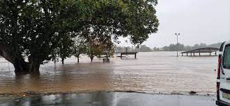
The United States is facing a wave of dangerous weather events as the National Weather Service continues to issue flash flood warnings across multiple states. Central Texas and parts of the Northeast, including New Jersey, are grappling with catastrophic rainfall, river surges, and mounting casualties. As of July 5, 2025, emergency alerts remain in effect, with authorities urging residents to seek higher ground and avoid flooded areas.
Flash Flood Warning Triggers Emergency Response in Central Texas
In the early hours of July 4, 2025, Central Texas was hit by a historic deluge. The remnants of Tropical Storm Barry unleashed torrential rain, causing the Guadalupe River to surge by over 29 feet in some locations. The National Weather Service responded swiftly, issuing six flash flood emergencies for cities like Kerrville, Mason, and Hunt. The river’s rapid rise led to widespread water rescues, with the city of Kerrville declaring a disaster by midday.
The scale of the disaster is staggering:
- At least 25 people have died in the Hill Country region, with hundreds initially reported missing.
- In Hunt, Texas, the river gauge recorded a 22-foot rise in just two hours before being submerged.
- Downstream, Kerrville and Comfort saw the river crest at over 21 and 29 feet, respectively.
- Camps, wildlife habitats, and entire neighborhoods along the riverbanks were inundated, forcing mass evacuations and prompting a large-scale search and rescue operation.
Governor Greg Abbott deployed state resources to assist affected communities, emphasizing the urgency of heeding official warnings and avoiding flooded roadways. Texas Game Wardens and other emergency teams continue to conduct rescues as floodwaters move downstream.
Read also-Camp Mystic Flooding: Latest Updates on Search, Rescue, and Community Response
Key Points Summary
- Catastrophic flash flooding in Central Texas has resulted in at least 25 deaths.
- The Guadalupe River surged by over 29 feet, overwhelming gauges and submerging communities.
- Multiple flash flood emergencies and disaster declarations are in effect.
- State and local officials are urging residents to seek higher ground and avoid flooded areas.
- Search and rescue operations are ongoing, with emergency services stretched across several counties.
Flash Flood Warning Cancels Major Events and Closes Roads
The impact of the flash flood warning extended beyond immediate rescue efforts. In Austin, city officials canceled the annual Fourth of July fireworks show and Star Spangled Fest at Auditorium Shores, citing saturated grounds and ongoing safety concerns. The Lower Colorado River Authority opened floodgates at Wirtz and Starcke Dams to manage storm runoff, further highlighting the severity of the situation.
Multiple road closures have been implemented to allow for the safe removal of event equipment and to protect drivers from hazardous conditions. Austin-Travis County EMS and the Austin Fire Department have been deployed to assist neighboring counties, including Kerr and San Saba, which have experienced some of the most devastating flooding in recent memory.
Flash Flood Warning in the Northeast: New Jersey on High Alert
While Texas battles river surges, the Northeast is bracing for its own set of challenges. On July 3, 2025, severe thunderstorms swept through New Jersey, prompting the National Weather Service to issue flash flood warnings for several counties. Residents faced intense downpours, strong winds, frequent lightning, and the threat of hail.
Key developments in New Jersey:
- Thunderstorm cells brought damaging wind gusts of up to 70 mph and heavy rainfall, leading to localized flooding.
- The National Weather Service warned that additional severe storms could develop, increasing the risk of flash flooding throughout the evening.
- Authorities advised residents to remain indoors, avoid driving through flooded streets, and monitor local forecasts for updates.
Flash Flood Warning: What You Need to Know and Do Now
With flash flood warnings active in multiple regions, safety is paramount. The National Weather Service and local officials emphasize the following precautions:
- Never drive through flooded roads—just six inches of moving water can stall a car, and two feet can sweep it away.
- Move to higher ground immediately if you are in a low-lying area or near a stream, creek, or drainage channel.
- Monitor official channels for the latest updates, including emergency alerts, social media posts from local agencies, and weather apps.
- Prepare for power outages and disruptions to utilities, especially in areas with ongoing rescue and recovery operations.
Table: Flash Flood Warning Impact by Region
| Region | Main Threats | Emergency Actions | Notable Events |
|---|---|---|---|
| Central Texas | River surges, mass flooding | Disaster declarations, rescues | 25+ deaths, Kerrville disaster, event cancellations |
| New Jersey | Severe storms, urban flooding | Shelter-in-place, alerts | Severe thunderstorms, hail, power outages |
Social Media and Real-Time Updates
Residents are turning to platforms like Twitter, Instagram, and Facebook for real-time updates, sharing images of rising waters, rescue operations, and community support efforts. Emergency services are using these channels to broadcast urgent warnings and safety tips, ensuring that critical information reaches as many people as possible.
Conclusion
The current flash flood warning underscores the unpredictable and deadly nature of extreme weather events. As rivers continue to rise and storms threaten new areas, vigilance and swift action are essential. Stay informed, follow official guidance, and prioritize safety for yourself and your community.
Stay alert for further updates on the flash flood warning, and share this information with friends and family to help keep everyone safe.
If you are in an affected area, monitor local alerts, move to higher ground if needed, and avoid all flooded roads and waterways. Your safety depends on quick, informed action.
