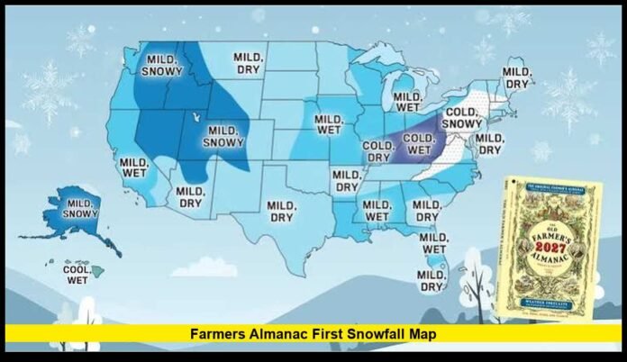

The farmers almanac first snowfall map offers a regional look at when Americans typically see the season’s first snow, with timing ranging from late summer in the highest mountains to winter across much of the South.
The latest map provides a broad picture of snowfall timing across the Lower 48 states. It does not assign one specific day to every city. Instead, it places regions into general periods based on historical snowfall patterns and geographic differences.
That distinction is important as the United States moves toward fall. Some mountain communities can see their first snow surprisingly early, while locations along the Gulf Coast may go through an entire winter without measurable snowfall.
For residents tracking the arrival of colder weather, the map provides a useful way to understand when snow typically begins in different parts of the country.
What the Farmers Almanac Map Reveals
The national map divides the country into broad snowfall periods. Northern and mountainous areas generally appear in the earliest categories, while southern and lower-elevation locations fall into later periods.
The overall progression follows a familiar pattern:
- High mountain areas can see snow as early as August or September.
- Northern states commonly enter their first-snow period during October.
- Much of the Upper Midwest, Great Lakes and interior Northeast typically reach that stage in November.
- Central and Mid-Atlantic areas often see their first measurable snow from late November into December.
- Parts of the South can wait until December or January, while some locations rarely see measurable snow.
These ranges should be viewed as regional indicators rather than guaranteed dates.
A city can receive snow outside its usual window. A cold storm may arrive earlier than normal, or an unusually warm autumn can delay the first measurable snowfall.
Why Snow Arrives at Different Times
Location has a major influence on the beginning of the snow season.
Latitude is one of the most obvious factors. Northern states generally experience colder conditions earlier because they receive less solar heating as autumn progresses.
Elevation creates another major difference. Mountain peaks can reach freezing temperatures while nearby valleys remain several degrees warmer.
Bodies of water also affect snowfall timing. The Great Lakes can produce lake-effect snow when cold air moves across relatively warm water. That process can produce heavy snow in localized areas while nearby communities receive little accumulation.
The result is a country where the first snow can occur at dramatically different times.
A mountain community in the West can experience snow while residents in a nearby lowland city are still enjoying mild fall temperatures. Meanwhile, parts of Florida may remain snow-free throughout the winter.
August and September Snow in the Mountains
The earliest snowfall category applies mainly to high-elevation locations and far northern mountain terrain.
Snow at these elevations does not necessarily signal an immediate start to winter for surrounding communities. Temperatures can rise significantly during the day, allowing early snow to melt soon after it falls.
Mountain weather can also change quickly. A cold front may temporarily push temperatures below freezing before warmer conditions return.
For that reason, early snow on a high peak should not be interpreted as proof that an entire state has entered its winter season.
The timing becomes more meaningful when snow begins reaching lower elevations and remains on the ground for longer periods.
October Marks an Important Transition
October becomes a significant month for the first snowfall across northern parts of the country.
The northern Rockies, northern Plains, Upper Midwest and higher elevations of the Northeast can begin experiencing measurable snowfall during this period.
Colorado provides a useful example of the variation. Denver’s historical average for its first measurable snowfall falls in October, but the actual date can change considerably from year to year.
That variability is a central feature of autumn weather.
A storm arriving with sufficiently cold air can produce snow much earlier than the average. A warm weather pattern can delay the first measurable accumulation.
The same principle applies to other northern cities.
An October snow event does not necessarily mean a snowy winter will follow. Early-season snow can disappear quickly when temperatures rebound.
November Expands the Snow Zone
By November, the area capable of receiving its first measurable snowfall becomes much larger.
The Upper Midwest, Great Lakes, interior Northeast and central mountain regions commonly reach their first-snow period around this time.
Minnesota is among the states where November snowfall becomes an important part of the seasonal transition. The Twin Cities typically record their first measurable snowfall in early November.
Western New York also enters the snow season around this period, although lake-effect events can create substantial local differences.
The November pattern also reaches parts of the central Plains and higher elevations farther south.
For many residents, this is the point when snow becomes a realistic possibility rather than an unusual early-season event.
The Great Lakes Can Change the Timing
The Great Lakes are especially important when discussing the first snowfall.
During autumn, lake water can remain warmer than the surrounding air. When colder air moves over the lakes, it can absorb heat and moisture.
That moisture can later fall as snow once the air reaches land.
Lake-effect snow can be highly concentrated. A narrow band may produce significant accumulation in one community while another location nearby receives only a few flakes.
This explains why snowfall records can differ substantially between areas around the same lake.
The effect is especially notable around lakes Erie, Ontario, Michigan and Superior.
As temperatures fall through autumn, lake-effect activity can become one of the first major sources of accumulating snow in parts of the Great Lakes region.
The Northeast Has Wide Regional Differences
The Northeast does not have one uniform first-snow date.
Northern and higher-elevation areas can see snow during October. Interior locations farther south commonly move into November.
Coastal areas often have a later transition because temperatures near the Atlantic can remain milder.
The Appalachian Mountains add another layer. Higher elevations can experience snow while nearby lower elevations receive rain.
This means a statewide first-snow date can hide substantial differences between communities.
Residents should therefore consider their elevation and distance from the coast when interpreting a regional map.
The Central United States Usually Waits Longer
The central Plains and Ohio Valley generally enter their first-snow period later than the northern Plains and Upper Midwest.
Late November and December become increasingly important.
Kansas, Missouri, parts of Nebraska, Illinois, Indiana, Ohio and neighboring areas can experience their first measurable snow during this broader transition.
Snowfall in this region can be especially variable because temperatures often hover near the freezing mark.
A storm may begin with rain, change to wet snow and then end before significant accumulation develops.
Small temperature differences can therefore determine whether a location records measurable snow.
December Becomes Important Across the Mid-Atlantic
For many Mid-Atlantic communities, December is a more typical time for the first measurable snowfall.
The timing can vary between inland and coastal locations.
Higher elevations generally have a greater chance of seeing snow earlier. Areas closer to the Atlantic can remain warmer, making rain more likely during marginal winter storms.
Even within the same metropolitan area, elevation can influence whether snow accumulates or melts on contact.
That makes broad regional maps useful for context but unsuitable for predicting the exact day of the first snowfall in an individual neighborhood.
The South Has the Latest Snow Window
The southern United States occupies the latest portion of the map.
Parts of Texas, Louisiana, Mississippi, Alabama, Georgia, South Carolina and Florida can have very limited measurable snowfall.
Some locations may go several winters without recording an accumulation that would be considered significant.
The reason is simple: snow requires more than cold temperatures.
The atmosphere must also provide enough moisture, and the temperature profile from the clouds to the ground must remain cold enough for snow to survive the trip to the surface.
Near the Gulf Coast and across Florida, those conditions occur far less often than they do in the northern United States.
As a result, a December or January first-snow window in the South does not mean residents should expect snow every winter.
First Flakes and First Measurable Snow Are Different
Snowfall records require careful interpretation.
The first visible snowflakes of the season may not produce any accumulation. They can melt as soon as they touch the ground.
Meteorological records commonly distinguish between a trace of snow and measurable snowfall.
A measurable snowfall is generally recorded when at least 0.1 inch accumulates.
Another important milestone is the first snowfall reaching one inch.
These events can occur on separate days or even weeks apart.
For example, a city could see a brief flurry in October, record its first measurable snowfall in November and experience its first one-inch snowfall in December.
All three events are part of the winter story, but they represent different measurements.
Elevation Can Be More Important Than State Borders
A map based only on state boundaries cannot fully explain snowfall timing.
Colorado illustrates this clearly. Mountain communities sit at much higher elevations than Denver and other Front Range locations.
The same storm can therefore produce accumulating snow in the mountains while producing rain or no precipitation at lower elevations.
The pattern is repeated in the Sierra Nevada, Cascades, Rockies and Appalachians.
Residents living near mountain terrain should pay close attention to elevation when interpreting regional snowfall timing.
A location only a few miles away can experience a very different first-snow date if it sits several thousand feet higher.
The Map Is Not a Specific-Day Forecast
One of the most important points for readers is that a climatological map cannot tell them exactly when their first snow will fall.
The map describes typical timing based on historical patterns.
A specific snowstorm requires a separate weather forecast that examines current atmospheric conditions.
Those conditions can change rapidly during autumn.
A warm September does not eliminate the possibility of an October snowstorm in the northern mountains. Likewise, a cold November does not guarantee snow in every northern city.
The map is most useful when combined with short-range forecasts as the season approaches.
How to Use the Map for Your Location
Residents can get more value from the map by considering several factors together.
First, identify the broad region where the location sits.
Next, consider elevation. A higher location generally has an earlier opportunity for snowfall.
Then consider nearby water. Great Lakes communities, for example, can experience localized snow because of lake-effect processes.
Finally, look at historical climate information for the specific city.
These factors provide more useful context than simply looking at a national snow boundary.
The result is a better understanding of why one city may report its first flakes weeks before another city at a similar latitude.
What the First Snow Pattern Means for Fall 2026
The latest map places the United States on a gradual path toward the snow season rather than showing one nationwide transition.
The highest mountain areas are the first places where snow becomes possible. Northern states follow as October approaches.
November brings the first measurable snow window to a much larger portion of the country.
By late November and December, the typical first-snow period reaches farther south and east.
Southern coastal areas remain the least likely to receive measurable snowfall.
This geographic progression is the central message of the map.
It also explains why social media reports of early snow should be viewed in context. A photograph of snow on a mountain summit does not mean that the entire surrounding region has entered winter.
Why the First Snow Gets So Much Attention
The first snow of the season is more than a weather statistic for many Americans.
It signals a visible change in the season. Roads can become slick, temperatures can drop sharply and outdoor conditions can change within hours.
For communities accustomed to heavy winter weather, the first measurable snowfall also marks the beginning of a period when larger storms become increasingly possible.
In areas that rarely receive snow, even a small accumulation can become a major local event.
That difference makes snowfall timing especially interesting across the United States.
The same weather system can be routine in Minnesota but unusual in parts of Georgia or Texas.
The Biggest Takeaway From the Map
The latest Farmers Almanac snowfall map shows that the arrival of snow follows a broad north-to-south and high-to-low elevation progression.
Mountain peaks can see snow during late summer. Northern states increasingly enter the snow season during October. November becomes a key month for the Upper Midwest, Great Lakes and interior Northeast.
The central United States and Mid-Atlantic generally move into later first-snow windows. Much of the South has the latest timing, with measurable snowfall remaining uncommon in some areas.
Most importantly, the map does not promise a specific date.
It gives readers a regional benchmark for when the first snow normally becomes possible. Actual conditions can shift that timing earlier or later.
For anyone watching the approach of winter, that makes the map a useful starting point for understanding what comes next across their part of the country.
Have you already seen the first signs of snow where you live, or are you still waiting for the season to begin? Share your local snowfall timing and stay informed as conditions change.