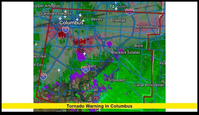

Columbus Ohio tornado warnings remain a key concern for residents after severe thunderstorms triggered a tornado warning across parts of the Columbus area Saturday night. The warning covered southeastern Franklin County and northwestern Fairfield County and included communities near Columbus, Canal Winchester, Groveport and Pickerington. The warning has since expired, but additional thunderstorms remain possible across central Ohio on Sunday.
The latest weather situation comes just days after a confirmed EF1 tornado struck south Columbus during a major severe-weather event on August 11. That tornado produced estimated peak winds of 100 mph and traveled 1.8 miles through the area.
Central Ohio continues to face the risk of strong thunderstorms, heavy rain and damaging winds. Residents should remain alert because storms can intensify quickly, especially when several rounds of thunderstorms move through the same area.
Latest Tornado Warning for the Columbus Area
The most recent tornado warning affecting the Columbus area was issued late Saturday night, August 15.
The National Weather Service issued the warning for southeastern Franklin County and northwestern Fairfield County. At the time, a severe thunderstorm capable of producing a tornado was near Canal Winchester and moving east at roughly 20 mph.
The warning included several communities in and around the southeastern Columbus area, including:
- Columbus
- Canal Winchester
- Groveport
- Pickerington
- Lithopolis
- Carroll
- Brice
- Blacklick Estates
The warning remained in effect until 11:30 p.m. EDT.
Radar showed rotation within the storm. That led forecasters to issue the tornado warning and urge people inside the affected area to seek shelter.
The warning did not confirm that a tornado had touched down. Instead, it identified a dangerous thunderstorm with the potential to produce a tornado.
That difference is important when reporting severe weather. A tornado warning can result from radar evidence, a trained weather spotter report or a confirmed tornado. The latest Columbus-area warning was based on radar-indicated rotation.
The Saturday Night Warning Has Expired
There is no longer an active tornado warning from that Saturday night alert.
However, the end of one warning does not mean residents can stop watching the weather. The Columbus forecast still calls for showers and thunderstorms on Sunday, with storms possible during the afternoon and evening.
The current forecast calls for a high near 86 degrees in Columbus on Sunday. The chance of precipitation remains elevated, and thunderstorms could develop during the afternoon.
That forecast makes continued weather awareness important for residents who are spending time outdoors or traveling across central Ohio.
A storm does not need to produce a tornado to become dangerous. Strong wind gusts, lightning, heavy rainfall and flooding can also create serious hazards.
Sunday Weather Keeps Columbus Residents on Alert
The weather pattern remains active across central Ohio.
Forecasters expect showers and thunderstorms to remain possible through Sunday. Some storms may become strong, bringing periods of heavy rainfall and gusty winds.
The threat is not limited to one neighborhood.
Thunderstorms can develop in one part of Franklin County while conditions remain relatively quiet only a few miles away. That makes location-specific warnings especially important.
Residents should check alerts for their exact location rather than relying only on conditions outside their homes.
A storm warning for southeastern Franklin County does not automatically mean that every part of Columbus faces the same threat.
Weather alerts can change quickly as storms move and strengthen.
What Happened During the August 11 Columbus Tornado
The latest warning came only a few days after a confirmed tornado struck south Columbus.
The National Weather Service completed a storm survey and classified the tornado as EF1 on the Enhanced Fujita scale.
Officials estimated maximum winds at 100 mph.
The tornado traveled approximately 1.8 miles and reached a maximum width of about 100 yards. The official survey found no fatalities or injuries from that tornado.
The August 11 storm was part of a much larger severe-weather event that affected central Ohio.
Strong straight-line winds also caused damage in other parts of the Columbus region. Downed trees, damaged structures and power problems affected residents across the area.
The confirmed tornado makes the recent warnings especially significant for people living in and around Columbus. It also demonstrates why residents should act quickly when officials issue a warning.
A Tornado Warning Does Not Always Mean a Tornado Is on the Ground
Many people use the terms tornado watch and tornado warning interchangeably, but they describe different levels of risk.
A tornado watch means conditions are favorable for tornado development. Residents should stay prepared and monitor weather updates.
A tornado warning means a tornado has been detected or that a storm has developed characteristics that could produce one. People inside the warning area should take immediate protective action.
The latest Columbus-area warning fell into the second category.
Radar detected rotation inside the storm near Canal Winchester. Forecasters responded by issuing the warning for southeastern Franklin County and northwestern Fairfield County.
Residents should never wait for visual confirmation before taking shelter.
Tornadoes can remain hidden by heavy rain. They can also develop quickly and move across an area before residents have time to react.
Why Columbus Tornado Sirens Matter
Tornado sirens remain an important part of emergency communication in Franklin County.
The outdoor warning system alerts people who may be outside when severe weather threatens. Sirens can provide an important signal that residents need to seek additional information and move indoors.
However, residents should not depend on sirens alone.
Sirens are designed primarily for outdoor warning. People inside homes, apartments, offices and other buildings may not hear them clearly.
Modern homes can also block outdoor siren sounds.
For that reason, residents should maintain several ways to receive severe-weather alerts. Smartphone emergency notifications, weather radios and official weather information can provide additional protection.
A person should take action when an official warning covers their location even if they never hear a siren.
Where to Take Shelter During a Tornado Warning
The safest place during a tornado is a sturdy building with a basement or designated storm shelter.
If a basement is available, residents should move there and stay away from windows.
People without basements should choose a small interior room on the lowest floor. Bathrooms, closets and interior hallways can provide better protection than rooms with large windows.
Residents should put as many walls as possible between themselves and the storm.
During a warning, people should:
- Move indoors immediately.
- Go to the lowest safe floor.
- Stay away from windows.
- Keep away from exterior doors and walls.
- Protect the head and neck.
- Bring pets indoors when possible.
- Remain sheltered until the warning expires.
People should also avoid standing near windows to watch a storm.
A tornado can cause flying debris even when it does not pass directly over a home.
Drivers Face Extra Risks During Severe Weather
Tornado warnings create additional problems for people traveling through Columbus.
Drivers may encounter heavy rain, strong winds, fallen trees, debris and poor visibility.
A vehicle does not provide reliable protection from a tornado.
If a sturdy building is nearby, drivers should leave the roadway and seek shelter inside. People should avoid stopping under bridges or overpasses because those locations do not provide dependable tornado protection.
Flooding creates another major concern.
Heavy rainfall can quickly cover roads and make driving dangerous. Water can hide damaged pavement, debris and other hazards.
Drivers should never attempt to cross a flooded road simply because the water appears shallow.
Heavy Rain Is Another Concern for Columbus
Tornadoes have received much of the attention because of the recent warnings, but heavy rain remains an important part of the current Columbus weather threat.
Repeated thunderstorms can drop large amounts of rain over the same areas.
When rainfall occurs faster than drainage systems can handle, water can collect on streets and low-lying areas.
Central Ohio has already experienced significant rainfall and storm activity during the current period of severe weather.
Residents should therefore monitor flood alerts as closely as tornado warnings.
A storm that does not produce a tornado can still cause major problems through flooding and damaging winds.
How the August 11 Storm Changed the Weather Conversation
The August 11 severe-weather event created widespread damage across Columbus and central Ohio.
The city declared an emergency following the storm. Officials responded to damage involving trees, buildings, roads and utilities.
The confirmed EF1 tornado in south Columbus became one of the most significant findings from the event.
The National Weather Service survey provided specific measurements for the tornado, including its estimated wind speed, path length and width.
Those findings distinguish confirmed tornado damage from reports that circulate online immediately after a storm.
That distinction is especially important when residents share videos and photographs on social media.
A dramatic video does not automatically establish where a tornado occurred or how strong it was.
Official surveys provide the final confirmation used to classify a tornado.
Why Radar-Indicated Rotation Matters
Weather radar gives forecasters an important tool for detecting dangerous storms before a tornado becomes visible.
Radar can identify areas where winds inside a thunderstorm are moving in different directions. When that circulation becomes strong enough, forecasters may issue a tornado warning.
This technology can provide residents with additional time to reach shelter.
The Saturday night warning near Columbus followed this type of radar detection.
The storm near Canal Winchester showed rotation that concerned forecasters. Officials then warned communities across southeastern Franklin County and northwestern Fairfield County.
Residents should treat such alerts seriously even if they cannot see a funnel cloud.
Waiting to see a tornado can cost valuable time.
What Columbus Residents Should Watch For Next
The immediate tornado warning from Saturday night has expired, but Sunday remains an active weather day.
Thunderstorms remain possible across Columbus and central Ohio.
The latest forecast indicates that showers and thunderstorms could develop mainly during the afternoon. Additional storms may occur into the evening.
Strong storms can produce several hazards at the same time.
Residents should watch for:
- Rapidly increasing winds
- Frequent lightning
- Torrential rainfall
- Hail
- Flash flooding
- Tornado warnings
- Downed trees and power lines
Weather conditions can change faster than a normal forecast update.
Residents should keep their phones charged and make sure emergency alerts remain enabled.
What to Know About Columbus Ohio Tornado Warnings Today
The most recent tornado warning affecting the Columbus area was issued Saturday night for southeastern Franklin County and northwestern Fairfield County.
That warning expired at 11:30 p.m. EDT.
The storm showed radar-indicated rotation, but officials did not confirm a tornado touchdown from that warning.
The confirmed tornado in the area occurred on August 11. The National Weather Service classified it as an EF1 tornado with estimated peak winds of 100 mph.
Sunday still brings the possibility of thunderstorms across Columbus. The current forecast calls for a warm, humid day with showers and storms possible during the afternoon.
That means residents should continue monitoring official alerts even after the Saturday night warning has ended.
The best response to a new tornado warning remains simple: move indoors, get to a safe interior location and stay there until the danger passes.
How Residents Can Stay Ready
Severe weather preparation does not need to be complicated.
Every household should know where to shelter before a warning arrives.
A safe location should be easy to reach and away from windows. Residents should also keep phones charged and make sure emergency notifications can reach them.
Families with children should discuss where everyone will go during a warning.
Pet owners should also know how they will bring animals to a safe location quickly.
People who live in mobile homes should identify a nearby sturdy building before severe weather develops. Mobile homes do not provide the same protection as permanent structures during tornadoes.
These simple preparations can save critical minutes when a warning arrives.
The Bottom Line for Columbus Residents
The recent Columbus tornado warnings are part of an active stretch of severe weather across central Ohio.
The Saturday night warning for southeastern Franklin County and northwestern Fairfield County has expired. No tornado was confirmed from that warning.
However, the region still faces the possibility of thunderstorms on Sunday, and the recent EF1 tornado in south Columbus shows why residents should take official warnings seriously.
Weather conditions can change quickly. A storm that begins as ordinary rain can strengthen within a short period.
Residents should monitor official alerts, avoid unnecessary travel during severe storms and move to shelter immediately when a tornado warning covers their location.
Stay weather-aware across Columbus today, and share your local storm experience while keeping safety the top priority.