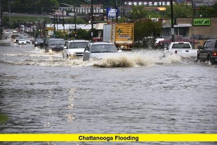
Chattanooga flooding has unleashed chaos across Tennessee Valley communities today, with torrential downpours inundating roadways, forcing highway closures, and prompting dozens of water rescues.
The deluge struck the Chattanooga area on Tuesday, August 12, 2025, delivering a staggering 6.42 inches of rain — the second-highest one-day total in Chattanooga history, behind only a major tropical storm event in 2011. Meteorologists say the combination of deep Gulf moisture and the region’s mountainous terrain created the perfect conditions for intense, prolonged rainfall.
Flash Flood Warnings remain active across southeastern Hamilton and southwestern Bradley counties into the evening, covering areas such as Chattanooga, East Ridge, Red Bank, and Ooltewah.
Flood Impacts: Roads, Rescues, and Resources
- Interstate 24 (I-24) — a major route through the region — was closed in both directions near McBrien Road due to deep floodwaters. Detours are limited, with many side streets also submerged.
- Emergency rescue teams have been highly active, evacuating motorists stranded on I-24, retrieving individuals from flooded homes, and helping residents trapped on inundated streets.
- One striking incident involved an officer wading through waist-deep water to rescue a woman stranded on a median after her car became stuck.
- A community storm shelter has been opened at Brainerd Recreation Center to assist those displaced by flooding.
- Safety officials remind residents that just six inches of fast-moving water can knock an adult off their feet, while a foot of water can stall or even sweep away a vehicle.
Why This Flood Was So Severe
The intensity of today’s Chattanooga flooding stems from a persistent band of thunderstorms, fueled by warm, moisture-rich air streaming from the Gulf of Mexico. With the city’s varied elevation and narrow drainage channels, the rainfall quickly overwhelmed stormwater systems, sending water surging across roadways and into homes.
Weather records confirm that this marks one of the wettest days in Chattanooga’s history, a rare occurrence outside of tropical storm seasons. The volume of rain that fell in less than 12 hours would normally be spread across several weeks in the summer.
Snapshot of Key Figures and Facts
| Metric | Detail |
|---|---|
| Rainfall | 6.42 inches in a single day |
| Record Rank | Second wettest day on record since the late 1800s |
| Highway Impact | I-24 closed near East Ridge; detours blocked by floodwaters |
| Rescues | Multiple by fire, police, and swift-water rescue teams |
| Shelters | Brainerd Recreation Center open for displaced residents |
| Warning Areas | Southeastern Hamilton & southwestern Bradley counties |
What’s Next?
Forecasts suggest the unstable weather pattern may persist through midweek before drier air begins to push into the Tennessee Valley. Additional scattered storms are possible, and any new rainfall could worsen flooding in already saturated areas.
Authorities urge residents to remain cautious:
- Avoid driving through flooded roads — even if the water appears shallow.
- Stay informed through local alerts and weather updates.
- Move to higher ground if you live near creeks, rivers, or other flood-prone areas.
- Check on neighbors who may need assistance, especially the elderly or those with mobility issues.
Community Response and Recovery
Public works crews are already clearing blocked storm drains and debris to improve water flow, while utility companies are working to restore power to pockets of the city affected by outages. Emergency shelters have been stocked with supplies, including food, blankets, and bottled water, to support residents displaced by the flooding.
Volunteers have stepped in to help distribute sandbags in low-lying neighborhoods. Social media platforms are filled with images and videos showing submerged cars, rushing street currents, and rescue boats navigating city intersections.
Staying Safe During Flood Events
Residents are reminded of these essential safety guidelines:
- Do not walk or swim through floodwaters — they may be contaminated or conceal sharp objects and dangerous currents.
- Listen to emergency personnel and follow evacuation orders when given.
- Secure important documents and valuables in waterproof containers.
- Have an emergency bag ready with medications, flashlights, and basic supplies.
As Chattanooga works to recover from today’s onslaught of rain, roads remain treacherous and floodwaters continue to pose dangers in several neighborhoods. Emergency crews remain on high alert until conditions improve. How has today’s storm impacted your neighborhood? Share your experience below and stay connected for more updates as this developing weather story continues.
