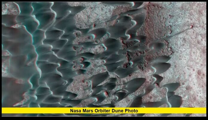

A fascinating NASA Mars orbiter dune photo is providing another look at the unusual landscapes that cover the Red Planet. The image reveals intricate sand formations shaped by wind, showing that Mars continues to experience surface changes even though its atmosphere is much thinner than Earth’s.
Martian dunes are among the most visually striking features captured by spacecraft orbiting the planet. Their curved ridges, rippled surfaces, and distinctive patterns can resemble deserts on Earth, but the conditions responsible for creating them are very different.
Scientists use these images to investigate how sand moves, how winds interact with the surface, and whether geological features are changing over time. The latest imagery also highlights the continuing importance of NASA’s long-running Mars observation missions.
The photograph is not simply a scenic view of another planet. It represents an important part of the scientific effort to understand Mars as an active world with environmental processes that continue today.
What the Mars Dune Image Reveals
The NASA Mars orbiter dune photo shows a landscape covered with sand formations that have developed into complex patterns. Some dunes appear curved, while others form long ridges and smaller ripples across the surrounding terrain.
These features are shaped by the movement of sand under the influence of Martian winds. Over time, grains can be transported, deposited, and rearranged, creating the distinctive patterns visible in orbital photographs.
The colors used in certain NASA images can also make the terrain appear unusual. Blue, purple, or other enhanced shades may be used to emphasize differences in surface materials, textures, or geological characteristics. These colors should not automatically be interpreted as the natural appearance of the Martian sand.
The detailed imagery gives scientists an opportunity to study the landscape from a perspective that would be impossible to achieve through ground-based observations alone.
NASA Continues Monitoring Sand Movement on Mars
NASA’s Mars Reconnaissance Orbiter has spent years examining the Martian surface. One of its most important instruments is the High Resolution Imaging Science Experiment, known as HiRISE.
The camera captures detailed images of the planet’s surface, allowing researchers to examine geological features that may be too small to identify clearly with other orbital instruments.
Scientists frequently return to previously photographed locations. Comparing older images with newer observations can help reveal whether sand has moved, dunes have shifted, or surface features have changed.
This long-term monitoring is particularly valuable because Mars has a thin atmosphere, and scientists continue investigating how wind activity influences the planet’s landscape.
Why Martian Sand Dunes Matter to Scientists
Sand dunes provide important evidence about the environmental conditions on Mars. Their shape, orientation, and movement can help researchers understand wind patterns and the processes responsible for transporting sand.
Although Mars has a significantly thinner atmosphere than Earth, its winds can still influence the surface under certain conditions.
Scientists examine dune structures to investigate several important questions:
- Wind direction: Dune shapes can provide clues about the direction of winds that helped form them.
- Surface activity: Changes in sand formations indicate that geological processes continue to operate on Mars.
- Sand movement: Repeated images can reveal whether sand is being transported from one location to another.
- Environmental conditions: Dune characteristics help researchers study the interaction between the atmosphere and surface.
- Climate history: Preserved dune structures may provide information about environmental conditions from earlier periods.
The ability to observe dunes over extended periods allows researchers to develop a better understanding of how the Martian environment operates.
The Mars Reconnaissance Orbiter’s Role in Planetary Research
The spacecraft behind many of NASA’s detailed Mars images is the Mars Reconnaissance Orbiter (MRO). It arrived in Mars orbit in March 2006 after launching in August 2005.
The mission was developed to investigate Mars’ geology, climate, atmosphere, and evidence of water. It also supports other Mars missions by helping scientists evaluate surface locations and serving as a communications relay for spacecraft operating on the ground.
MRO’s continued observations have created an extensive record of the planet’s surface. Researchers can examine the same locations at different times, making it easier to detect subtle changes that might otherwise go unnoticed.
The HiRISE camera is particularly useful for studying sand dunes, crater formations, exposed geological layers, and other surface features. Its high-resolution observations provide scientists with detailed information about Mars that supports both current research and future exploration planning.
Why Some Martian Dune Photos Have Unusual Colors
Many people notice the striking colors in NASA’s Mars photographs. Some dune images appear blue, purple, pink, or almost black, creating a dramatic contrast with the planet’s familiar reddish appearance.
However, the colors in these images may be enhanced rather than natural.
Scientific imaging techniques can combine different wavelengths of light or adjust color representations to make surface features more visible. This allows researchers to identify differences in materials and textures that might be difficult to detect in a conventional image.
Enhanced-color imagery can be especially helpful when examining areas where sand, rocks, dust, and other surface materials meet.
The visual presentation is designed to communicate scientific information. As a result, the colors should not be treated as an exact representation of the landscape as it would appear to a human observer standing on Mars.
How Scientists Detect Changes in Dune Landscapes
A single photograph can reveal the structure of a dune field, but multiple images captured over time provide much more information.
Researchers compare photographs from different years to determine whether particular formations have changed. They may look for movement along dune boundaries, differences in ripple patterns, new sand deposits, or changes in the overall shape of a dune.
These comparisons help scientists understand how environmental conditions influence the landscape.
For example, if sand formations have shifted between observations, researchers can investigate the wind conditions that may have contributed to the movement. If a particular feature remains relatively stable, scientists may examine whether local terrain or surface conditions are limiting sand transport.
Long-term observations are therefore an essential part of studying Mars. They allow researchers to distinguish between features that have remained largely unchanged and those that continue to evolve.
Mars Is Not a Completely Inactive World
For many years, Mars was often described primarily through its ancient geological history. Scientists investigated enormous volcanoes, impact craters, valleys, and evidence suggesting that water once existed on the planet’s surface.
However, orbital observations have increasingly demonstrated that Mars also experiences present-day activity.
Sand dunes can move. Dust can be transported across large areas. Seasonal changes can alter surface conditions, while other geological processes may affect individual locations.
The movement of sand is especially important because it demonstrates that the Martian landscape is not entirely static.
The thin atmosphere presents different challenges compared with Earth’s environment, but wind-driven activity remains an important factor in understanding the planet.
Why Dune Observations Could Matter for Future Mars Missions
Detailed images of Martian dunes may also have practical importance for future exploration.
Robotic vehicles and other surface equipment must operate in an environment where sand, dust, uneven terrain, and changing surface conditions can create challenges. Orbital imagery helps mission teams understand the characteristics of potential exploration locations before spacecraft arrive.
Dune fields can influence the selection of landing sites because their terrain may present obstacles or other operational considerations. Scientists and engineers study surface characteristics to help evaluate locations and better understand the environment that future missions may encounter.
Although a single dune photograph cannot determine whether an area is appropriate for a landing or exploration mission, it contributes to a broader collection of scientific observations used to assess the Martian surface.
Future human missions would also benefit from a better understanding of local terrain, dust activity, and environmental conditions.
A Major Achievement in Mars Imaging
The HiRISE camera has become one of the most valuable tools for studying Mars from orbit. Over the years, it has captured an enormous collection of images covering different regions of the planet.
These observations have helped researchers investigate craters, dunes, geological formations, potential landing locations, and evidence connected to Mars’ environmental history.
The camera’s extensive image archive is particularly useful because scientists can revisit earlier observations and compare them with newer data. That approach makes it possible to investigate changes that may take years to become visible.
The growing collection of Mars images also provides an important resource for researchers studying the planet from different scientific perspectives.
What Researchers May Discover From Future Dune Images
NASA’s continuing Mars observations could help answer several questions about the planet’s surface.
Researchers may gain a better understanding of how quickly dunes move in different regions, which wind conditions contribute to sand transport, and whether seasonal changes influence the appearance of particular dune fields.
Additional observations may also reveal whether smaller ripples change more frequently than larger dune structures. These differences could help scientists investigate the relationship between wind activity and the size of surface formations.
The longer scientists monitor these locations, the more useful the observations become. A photograph taken years after an earlier image can provide information that cannot be obtained from a single observation.
Continued monitoring will remain important as researchers work to understand the current environment of Mars and prepare for future exploration.
Why the NASA Mars Orbiter Dune Photo Is Important
The NASA Mars orbiter dune photo offers an impressive view of a landscape that continues to change under the influence of wind and other environmental processes.
Its unusual formations help demonstrate how sand can create complex patterns on another planet. At the same time, the image highlights the scientific value of repeatedly photographing the same locations and comparing their surface features over time.
Mars may appear quiet from a distance, but orbital observations continue to reveal evidence of activity. Dunes, ripples, dust, and other features provide researchers with clues about the planet’s current environmental conditions.
The photographs collected by NASA’s orbiters are helping scientists move beyond studying Mars as a world shaped only by ancient events. They are also investigating the processes happening today.
As new observations become available, researchers may uncover additional changes across Martian dune fields, offering further insight into the winds and environmental forces that shape the Red Planet.
Frequently Asked Questions
What does the NASA Mars orbiter dune photo show?
The image shows Martian sand dunes and ripple-like formations shaped by wind. Scientists study these structures to understand sand movement, surface conditions, and environmental activity on Mars.
Why do Martian dunes have unusual colors in NASA images?
Some photographs use enhanced-color processing to make surface differences easier to identify. The colors may highlight materials and textures rather than represent the landscape’s natural appearance.
Are sand dunes actively moving on Mars?
Yes. Researchers have documented movement in Martian dunes and ripples by comparing orbital images collected at different times. These observations demonstrate that wind continues to influence the planet’s surface.
Which NASA camera takes detailed pictures of Mars dunes?
The HiRISE camera, aboard NASA’s Mars Reconnaissance Orbiter, captures highly detailed images of the Martian surface, including dunes, craters, rocks, and geological formations.
Why does NASA photograph the same dune fields repeatedly?
Repeated observations allow scientists to identify changes that may occur over months or years. Comparing images helps researchers investigate sand movement, wind activity, and other surface processes.
What can Mars dune images tell scientists about the planet?
Dune images can provide information about wind direction, sand transport, surface activity, environmental conditions, and the geological history of Mars.
Conclusion
Martian dunes offer an extraordinary opportunity to study a planet that continues to experience environmental activity. The NASA Mars orbiter dune photo highlights the intricate formations created by wind while demonstrating the importance of detailed, long-term observations. As spacecraft continue monitoring the Red Planet, scientists will gain a clearer understanding of how its surface changes and what those changes reveal about Mars.
What do you find most fascinating about Mars’ changing landscape? Share your thoughts and keep following the latest discoveries from space exploration.