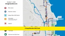

The Chicago Marathon 2026 route takes runners across 26.2 miles of Chicago on Sunday, October 11, with the start and finish located in Grant Park. The 48th running of the Bank of America Chicago Marathon follows a loop through 29 neighborhoods, covering the city’s downtown streets and North, West, and South Side communities. The official course information also highlights 20 aid stations, medical support, hydration options, and race-day street closures. Runners and spectators can use the official course map and the marathon’s mobile app to understand the route and follow participants throughout race day.
Chicago Marathon 2026 Route: Key Details
- Race: Bank of America Chicago Marathon
- Race date: Sunday, October 11, 2026
- Distance: 26.2 miles
- Start and finish: Grant Park, Chicago
- Start-line location: Columbus Drive and Monroe Drive
- Course coverage: 29 Chicago neighborhoods
- Aid stations: 20
- Course time limit: 6 hours and 30 minutes
- Official tracking: Bank of America Chicago Marathon app, powered by TCS
The official course map remains the best reference for the precise street layout. Organizers note that the route is subject to change, so runners and spectators should check the latest event information before making travel plans.
Where Does the Chicago Marathon 2026 Route Start and Finish?
Grant Park serves as the central location for both the start and finish of the 2026 Chicago Marathon. The starting line is at Columbus Drive and Monroe Drive, placing runners near downtown Chicago and the city’s lakefront.
From there, participants begin a 26.2-mile journey through the city before returning to Grant Park. The loop-style route allows runners to experience a broad cross-section of Chicago without traveling to a separate finishing location outside the city center.
However, the start and finish areas have restricted access. Spectators cannot freely enter the designated race start and finish zones in Grant Park. Access is reserved for registered participants displaying their race bibs, authorized event personnel, and ticketed guests where applicable.
Friends and family should arrange to watch from accessible locations along the course rather than expecting to accompany runners to the starting line or stand directly at the finish.
Chicago Marathon 2026 Route Map: How to Find the Official Course
The official Chicago Marathon course page provides the course map and information about aid stations, medical facilities, the time limit, and street closures.
Runners should review the map before race day to understand how the course travels through the city. Spectators can use it to identify suitable viewing locations and plan transportation between different sections.
The official marathon app, powered by Tata Consultancy Services, offers an interactive course map and live race-day runner tracking. It also includes participant bib sharing, professional athlete profiles, live broadcast streaming, and race results as they become available.
These resources are especially useful for people supporting runners remotely or moving between viewing locations throughout the day.
The course map should be treated as the authoritative reference for exact turns, street names, and mile markers. A general neighborhood description cannot replace the official map when planning a specific crossing or spectator route.
Which Neighborhoods Does the Chicago Marathon 2026 Route Cover?
The marathon’s 29-neighborhood course is one of its defining features. Instead of keeping runners on a single downtown circuit, the route extends into multiple parts of Chicago, giving participants and spectators a view of the city’s varied communities.
The course travels through sections of downtown, the North Side, the West Side, and the South Side. The atmosphere changes as runners move between commercial districts, residential streets, and neighborhoods known for their local cultural traditions.
Several well-known course areas provide particularly recognizable viewing points:
- Downtown and the Loop: The early miles take runners through the central business district, where tall buildings and busy streets frame the race.
- Lincoln Park and the North Side: Runners travel through northern parts of the city, where spectators gather along neighborhood streets.
- Northalsted: This area is known for its lively spectator atmosphere and enthusiastic local support.
- The West Side: The course showcases communities beyond the downtown core, with residents gathering along the route.
- Pilsen: Spectators bring neighborhood character and cultural celebrations to the race.
- Chinatown: This South Side course area offers another popular place to cheer runners.
- Bronzeville and surrounding South Side areas: Runners progress through additional communities before completing the later miles toward Grant Park.
These areas are useful reference points, but their precise positions on the course should be confirmed on the official map. Anyone planning to watch from multiple neighborhoods should account for race progress, public transportation, security arrangements, and street closures.
Chicago Marathon 2026 Route by Race Stage
Understanding the route by race stage can help runners prepare mentally for the distance and help spectators choose where to watch.
Early miles: Downtown Chicago
The race begins in Grant Park and moves onto downtown streets. Runners experience the energy of the starting crowds as they settle into their pace. The early miles are an opportunity to maintain a controlled effort rather than start too quickly.
For spectators, downtown offers several potential viewing areas. However, road closures and crowds can affect access, so checking the official street-closure information is essential.
Middle miles: North and West Side communities
As the race continues, runners leave the immediate downtown area and pass through neighborhoods across the North and West Sides. The changing surroundings provide a welcome distraction during a long race.
Spectators often look for locations with strong neighborhood support and convenient public transportation. Northalsted and sections of the West Side are among the areas associated with a lively marathon atmosphere.
Miles 13–21: The halfway point and South Side
The halfway mark comes at 13.1 miles. From there, runners continue toward additional neighborhoods, including Pilsen and Chinatown.
This section is important for runners because they have completed half the distance but still have a demanding stretch ahead. Spectators can use the course map to identify accessible places to cheer without attempting to cross closed streets.
Final miles: Return toward Grant Park
The later miles test endurance as runners work toward the finish. The course includes sections around the South Side before returning toward Grant Park.
Spectators looking for a late-race viewing point should plan carefully. Travel time between neighborhoods can be longer than expected when crowds gather and streets remain closed.
The finish area itself has access restrictions. Friends and family should use the official spectator guidance to determine where they can wait and reunite with runners after the race.
Chicago Marathon 2026 Aid Stations and Hydration Points
The official course includes 20 aid stations, generally spaced approximately one to two miles apart. These stations provide essential support for participants throughout the 26.2-mile race.
Standard aid-station amenities include:
- Water.
- Gatorade Endurance Formula in lemon-lime flavor.
- Medical tents.
- Portable toilets, including ADA-accessible facilities.
- Public-address announcements.
Medical support is available at 22 on-course locations. Medical tents are located at all 20 aid stations, with additional medical tents between miles 14 and 15 and in the final mile.
The course also includes dedicated hydration and fueling options. Four Culligan water-refill stations are positioned immediately before selected aid stations:
| Aid station | Approximate mile |
|---|---|
| Aid Station 4 | 5.7 |
| Aid Station 7 | 10.1 |
| Aid Station 12 | 15.7 |
| Aid Station 16 | 20.3 |
These stations allow participants to refill approved, self-carried hydration equipment. Permitted options include handheld water bottles, soft flasks, fuel belts, and running vests with front-pocket carry. Hydration backpacks and running vests with hydration bladders are prohibited.
Maurten gel depots are available near mile 12.4 and mile 18.1. The course also offers bananas at aid stations 16 through 18, covering approximately miles 20.2 to 23.
Runners should review the official course rules before carrying any equipment or relying on a particular fueling option.
Chicago Marathon 2026 Route: Mile Markers and Timing
The marathon provides mile and kilometer markers to help runners follow their progress. Digital clocks appear at the start, at every five-kilometer point, and at the finish. Timing checkpoints include the start, each 5K, the halfway point, miles 20 through 25, mile 25.2, and the finish line.
These checkpoints help participants understand their pace and provide spectators with reference points for estimating when a runner may arrive.
A personal GPS watch or phone may display a slightly different distance from the official course markers. The official measured course determines the race distance, so runners should use the designated markers as their primary reference.
The official marathon app also provides live runner tracking. Spectators can look up participants using available bib information and follow their progress during the race.
Chicago Marathon 2026 Street Closures Along the Route
Street closures are a major consideration for anyone traveling through Chicago on race day. Organizers list Sunday, October 11, as the date for the 2026 event’s extensive road restrictions.
Streets along the course are scheduled to close beginning at 6 a.m., with closures continuing through the afternoon. The official street-closure page lists anticipated reopening times by course section. Streets generally reopen as the final runners pass and traffic-safety officials determine that it is safe to do so.
Parking restrictions begin at 1 a.m. on race day along the course. Vehicles left in posted no-parking zones may receive tickets and be towed.
Some important transportation details include:
- DuSable Lake Shore Drive: Northbound and southbound lanes are scheduled to remain open.
- Dan Ryan Expressway (I-90/94): Eastbound and westbound lanes are scheduled to remain open.
- Kennedy Expressway (I-90/94): Both directions are scheduled to remain open, although the Adams Street exit ramp is listed as closed.
- Eisenhower Expressway (I-290): Eastbound and westbound lanes are scheduled to remain open.
- Stevenson Expressway (I-55): Northbound and southbound lanes are scheduled to remain open.
These are planned arrangements, not a guarantee that every nearby street or access point will remain unaffected. Police and marathon officials may adjust closures when necessary for safety.
Residents, visitors, and spectators should check the official street-closure schedule and local transportation alerts before setting out. Anyone who needs to cross the route should follow police directions and use designated crossing opportunities.
Best Ways to Watch the Chicago Marathon 2026 Route
Spectators can watch the marathon from locations along the course, but choosing a viewing point requires some planning. The best location depends on whether someone wants to see the start of the race, support a runner around the halfway point, or cheer during the final miles.
Chicago’s CTA rail system can help spectators move between neighborhoods. The official spectator information recommends using public transportation and estimating a runner’s arrival time based on their planned pace.
For a more organized race-day plan, spectators should:
- Identify the runner’s bib number and planned pace.
- Choose viewing points that are accessible by public transportation.
- Check street closures before leaving.
- Allow enough time to travel between viewing locations.
- Arrange a meeting place outside the restricted finish area.
The marathon’s official app can help spectators follow participants and adjust their plans as race progress becomes available. The designated Runner Reunite area in Grant Park provides a place for runners and their supporters to reconnect after finishing.
Chicago Marathon 2026 Route and the Course Time Limit
The official course time limit is six hours and 30 minutes. Participants must maintain an approximate pace of 15 minutes per mile or faster to receive full course support from aid stations and traffic-safety personnel.
An event vehicle follows the final starters at the designated pace, helping officials determine when they can reopen streets to traffic.
Runners who fall behind the required pace may need to move onto the sidewalk as streets reopen. Participants who finish after the cutoff may not appear as official finishers in published results and may not receive full course support.
This policy matters for runners planning their race strategy. It also helps residents and spectators understand why road closures do not remain in place indefinitely.
Frequently Asked Questions About the Chicago Marathon 2026 Route
Where does the Chicago Marathon 2026 start?
The race starts in Grant Park at the intersection of Columbus Drive and Monroe Drive in Chicago.
Where does the Chicago Marathon 2026 finish?
The finish is in Grant Park, the same central park area that hosts the start.
How long is the Chicago Marathon 2026 route?
The course measures 26.2 miles, the standard marathon distance.
How many neighborhoods does the route cover?
The official course travels through 29 Chicago neighborhoods.
Where can I find the Chicago Marathon 2026 route map?
The official Bank of America Chicago Marathon website has a course page with the route map, aid-station details, medical information, and street closures. The official marathon app also includes an interactive course map.
Can spectators watch runners at the finish line?
Spectators cannot freely enter the designated start and finish areas in Grant Park. They should watch from permitted locations along the route and use the official post-race reunion arrangements.
How many aid stations are on the route?
The course has 20 aid stations, generally spaced one to two miles apart. These stations provide water, sports drink, portable toilets, and medical support.
Are Chicago Marathon streets closed all day?
No. The official schedule lists closures beginning at 6 a.m., with roads reopening as the final runners pass and officials determine it is safe. Exact times vary by location and may change.
Final Takeaway: Check the Official Chicago Marathon 2026 Route
The Chicago Marathon 2026 route combines a 26.2-mile course, 29 neighborhoods, and a Grant Park start and finish. Its downtown streets and neighborhood sections give runners a broad tour of Chicago, while spectators have multiple opportunities to support participants along the way.
For the most reliable race-day planning, use the official course map, check street-closure updates, and follow runner progress through the official marathon app. Have you picked your favorite spot along the Chicago Marathon 2026 route? Share your race-day plans or spectator tips in the comments, and check back for the latest verified updates.