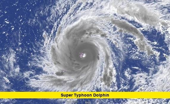

Super Typhoon Dolphin has become one of the most powerful tropical cyclones of the 2026 western Pacific season, rapidly intensifying over open water near Wake Island.
As of the latest National Weather Service advisory on July 30, 2026, Super Typhoon Dolphin was packing maximum sustained winds of 160 mph while moving northwest at approximately 10 mph. The storm remained southwest of Wake Island and was expected to continue across the open western Pacific between Wake Island and the far northern Mariana Islands.
Despite Dolphin’s extraordinary intensity, current forecasts indicate that the storm is not expected to directly affect the Mariana Islands or Micronesia. Wake Island remains the location requiring the closest attention as Dolphin passes through the region.
Super Typhoon Dolphin Latest Update
The National Weather Service in Guam reported in its July 30 Advisory Number 14 that the center of Super Typhoon Dolphin was located near 17.2 degrees north latitude and 164.5 degrees east longitude.
At that time, Dolphin was approximately:
- 200 miles southwest of Wake Island
- 825 miles north-northeast of Pohnpei
- 825 miles north of Kosrae
- 835 miles north-northwest of Majuro
- 1,250 miles east of Saipan
- 1,335 miles east-northeast of Guam
Maximum sustained winds were estimated at 160 mph, placing Dolphin at the equivalent of a Category 5 hurricane on the Saffir-Simpson Hurricane Wind Scale used in the United States.
The storm was moving northwest at approximately 10 mph.
Typhoon-force winds extended as far as about 50 miles from Dolphin’s center, while tropical-storm-force winds extended outward as far as approximately 125 miles.
How Strong Is Super Typhoon Dolphin?
Super Typhoon Dolphin is an exceptionally powerful tropical cyclone.
A Category 5 hurricane begins at sustained winds of 157 mph on the Saffir-Simpson scale. With winds around 160 mph in the latest NWS advisory, Dolphin comfortably meets the Category 5-equivalent threshold.
Earlier meteorological analysis from the National Weather Service indicated maximum sustained winds had reached approximately 165 mph while Dolphin was passing south of Wake Island.
Small differences between advisories and agencies are normal because tropical cyclone intensity can fluctuate and agencies may use different averaging periods and observation methods.
The National Weather Service described Dolphin as having a well-defined eye after recovering from an eyewall replacement cycle.
An eyewall replacement cycle occurs when a powerful tropical cyclone develops a new ring of thunderstorms outside its original eyewall. The outer eyewall can eventually replace the inner one, temporarily changing the cyclone’s wind speed and structure.
Dolphin subsequently reorganized and remained an extremely intense super typhoon.
Where Is Super Typhoon Dolphin Heading?
The latest official forecast has Dolphin continuing generally toward the northwest before making a gradual turn toward the west-northwest.
Its forward speed could increase slightly through Friday.
The expected path takes Dolphin across open ocean between Wake Island and the far northern Commonwealth of the Northern Mariana Islands.
This track is important because it currently keeps the storm’s destructive inner core away from the main populated islands of the Marianas and Micronesia.
However, tropical cyclone forecasts can change as atmospheric steering patterns evolve. Anyone with interests across the western Pacific should continue checking official forecasts.
Is Super Typhoon Dolphin Going to Hit Wake Island?
Wake Island is among the areas being watched most closely.
According to the July 30 National Weather Service advisory, Dolphin was approximately 200 miles southwest of Wake Island.
No tropical cyclone watches or warnings were listed in that particular public advisory, but the National Weather Service specifically advised residents of Wake Island to continue monitoring Dolphin’s progress.
The storm’s strongest winds remain concentrated relatively close to its center. However, Dolphin’s broader circulation can generate dangerous seas, swells and unsettled weather well beyond the eyewall.
The exact distance between the center and Wake Island during its closest approach will therefore remain important.
Will Super Typhoon Dolphin Hit Guam?
Current forecasts do not indicate a direct strike on Guam.
The National Weather Service said Super Typhoon Dolphin was not expected to produce direct impacts across the Marianas or Micronesia based on the projected track.
At the time of the latest advisory, Dolphin was approximately 1,335 miles east-northeast of Guam.
Although the cyclone itself is far away, large tropical systems can influence regional wind patterns.
Meteorologists in Guam have been monitoring how Dolphin’s circulation affects the broader western Pacific environment, including monsoonal flow around the Mariana Islands.
Residents should distinguish these indirect weather influences from a direct typhoon impact.
Will Super Typhoon Dolphin Affect Saipan or the Northern Mariana Islands?
A direct impact on Saipan is also not currently expected.
Dolphin was approximately 1,250 miles east of Saipan in the latest advisory and was forecast to travel through open ocean between Wake Island and the far northern CNMI.
The National Weather Service explicitly stated that Dolphin was not expected to pose direct impacts to the Marianas or Micronesia under the current forecast.
The situation nevertheless warrants monitoring because Dolphin remains an intense tropical cyclone and forecast tracks can shift.
Why Did Super Typhoon Dolphin Intensify So Quickly?
Dolphin developed in an environment highly favorable for tropical cyclone intensification.
National Weather Service analysis said the cyclone remained in conditions favorable for continued development.
Powerful tropical cyclones generally require several atmospheric and oceanic ingredients, including warm ocean water, abundant atmospheric moisture, low vertical wind shear and strong upper-level ventilation.
When those ingredients align, a tropical cyclone can intensify rapidly.
Dolphin demonstrated that process dramatically.
On July 27, the system was classified as Tropical Storm Dolphin, with maximum sustained winds around 40 mph in an NWS advisory.
By July 28, Dolphin had strengthened significantly. An NWS advisory that afternoon reported winds around 70 mph, and later that day the system was upgraded to a typhoon.
Less than two days later, Dolphin had become a violent super typhoon with Category 5-equivalent winds.
That represents an extraordinary increase in intensity over a relatively short period.
Dolphin’s Development From Tropical Storm to Super Typhoon
Dolphin’s evolution has been remarkably fast.
The system became Tropical Storm Dolphin on July 27, when it was northeast of the Marshall Islands.
At that stage, maximum sustained winds were approximately 40 mph.
By early July 28, winds had increased to around 50 mph.
Later that day, sustained winds climbed to approximately 70 mph before Dolphin reached typhoon intensity.
The cyclone then underwent further rapid strengthening over the exceptionally favorable western Pacific environment.
By July 29 and July 30, Dolphin had reached super typhoon status and eventually Category 5-equivalent intensity.
The progression illustrates how quickly tropical cyclones can strengthen when environmental conditions become highly favorable.
What Does “Super Typhoon” Mean?
The term super typhoon is used by the Joint Typhoon Warning Center for exceptionally intense tropical cyclones in the western North Pacific.
The terminology differs somewhat from the hurricane categories familiar to Americans.
A hurricane, typhoon and tropical cyclone are fundamentally the same type of weather phenomenon. The terminology changes according to the ocean basin where the storm develops.
In the Atlantic and eastern North Pacific, these storms are called hurricanes.
In the western North Pacific, they are called typhoons.
The strongest western Pacific typhoons can receive the designation super typhoon.
With maximum sustained winds around 160 mph, Dolphin is also comparable in wind intensity to a Category 5 hurricane.
How Large Is Super Typhoon Dolphin?
Dolphin is not only extremely intense but also surrounded by a substantial area of severe weather.
The July 30 NWS advisory reported that:
- Typhoon-force winds extended up to approximately 50 miles from the center.
- Tropical-storm-force winds extended outward up to approximately 125 miles.
Earlier satellite analysis also identified widespread heavy showers within roughly 120 miles of the center.
Feeder bands associated with the cyclone extended hundreds of miles away from its core.
These outer bands can produce heavy rainfall, thunderstorms and rough marine conditions even far from the eye.
Super Typhoon Dolphin’s Eye and Eyewall
Satellite observations have revealed an impressive structure around Dolphin’s center.
National Weather Service meteorologists reported a well-defined eye after the cyclone recovered from an eyewall replacement cycle.
A clear and symmetrical eye is often associated with an extremely intense and well-organized tropical cyclone.
Around the eye is the eyewall, where the cyclone’s strongest winds and most intense thunderstorms are typically concentrated.
Dolphin’s ability to reorganize after an eyewall replacement cycle helped it maintain extraordinary strength.
Could Super Typhoon Dolphin Become Even Stronger?
Some additional strengthening remains possible in the immediate term.
The July 30 National Weather Service advisory indicated that Dolphin was forecast to intensify through Friday.
Earlier NWS meteorological analysis similarly described the environment around Dolphin as very favorable for continued development before eventual weakening.
However, intensity forecasts for extremely powerful tropical cyclones are inherently difficult.
Eyewall replacement cycles, ocean temperatures, internal structural changes and changes in atmospheric wind shear can cause significant fluctuations in maximum wind speeds.
The key point is that Dolphin is already an exceptionally dangerous Category 5-equivalent tropical cyclone regardless of whether additional strengthening occurs.
When Will Super Typhoon Dolphin Weaken?
Dolphin cannot maintain its current extreme intensity indefinitely.
National Weather Service analysis indicated that the cyclone could remain in favorable conditions for further development before eventually beginning to weaken.
Exactly when significant weakening begins will depend on Dolphin’s track and the atmospheric and oceanic environment encountered along the way.
Changes in sea-surface temperatures, vertical wind shear, moisture and internal eyewall processes can all influence how quickly a super typhoon loses strength.
Forecast updates over the next several days should provide greater clarity.
Is Super Typhoon Dolphin Heading Toward Japan?
Dolphin’s longer-term track remains an important question.
For now, the immediate official forecast keeps the cyclone moving northwest and then more toward the west-northwest across the open western Pacific.
It is too early to treat any distant landfall scenario as certain.
Long-range tropical cyclone forecasts have greater uncertainty than short-range predictions because small changes in atmospheric steering currents can produce major changes in a storm’s eventual position.
Residents across the broader western Pacific should therefore rely on updated forecasts rather than individual long-range model runs.
Does Super Typhoon Dolphin Threaten the United States?
There is currently no threat to the continental United States from Super Typhoon Dolphin.
The cyclone is located deep in the western Pacific.
Wake Island, a remote U.S. territory in the Pacific, is much closer to the storm and remains an area where Dolphin is being carefully monitored.
Guam and the Northern Mariana Islands are considerably farther west of the cyclone’s current position, and direct impacts are not expected under the latest forecast.
Why Super Typhoon Dolphin Matters
Dolphin is significant because of the speed and magnitude of its intensification.
The cyclone evolved from a tropical storm into a Category 5-equivalent super typhoon in only a few days.
Its development offers another striking example of how quickly western Pacific tropical cyclones can intensify under favorable environmental conditions.
Fortunately, Dolphin’s current track keeps its destructive core primarily over open ocean.
That dramatically reduces the potential for catastrophic impacts compared with a similarly powerful storm approaching a heavily populated coastline.
Even so, the situation around Wake Island requires continued monitoring, while maritime interests across the region should remain aware of dangerous seas associated with the cyclone.
Super Typhoon Dolphin Latest Forecast: What Happens Next?
The immediate forecast calls for Dolphin to continue northwestward before turning somewhat more toward the west-northwest.
The storm should remain over open water between Wake Island and the far northern Mariana Islands during the next several days.
Some additional strengthening is possible before environmental conditions eventually become less favorable and Dolphin begins weakening.
For the moment, the most important facts are clear: Super Typhoon Dolphin remains an exceptionally powerful Category 5-equivalent cyclone, Wake Island remains the closest location being closely monitored, and no direct impacts are currently expected for the Marianas or Micronesia.
Because Dolphin remains active, its position, intensity and projected track will continue changing as new observations become available.
What do you think about Super Typhoon Dolphin’s extraordinary rapid intensification? Share your thoughts below and stay updated as new official forecasts are released.