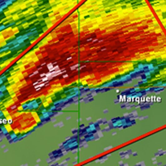
As of May 30, 2025, a weather tornado warning has brought significant disruptions to the Baltimore region, with BWI Airport facing a ground stop due to severe storms sweeping through the Mid-Atlantic. The National Weather Service (NWS) has issued urgent alerts for Maryland, Virginia, and the District of Columbia, warning of potential tornadoes, damaging winds, and flash flooding. This afternoon’s storms, fueled by warm, humid air clashing with cooler systems, have created hazardous conditions, prompting immediate action from authorities and residents alike. Here’s the latest on the situation, its impacts, and how to stay safe.
Weather Tornado Warning: Current Conditions
The NWS reported at 4:02 PM EDT today that scattered severe storms are moving across the Mid-Atlantic, with a tornado watch in effect until midnight. These storms carry risks of wind gusts up to 70 mph, large hail, and isolated tornadoes. A weather tornado warning specifically targeting the Baltimore area, including BWI Airport, was issued this evening, leading to a ground stop that has halted all flights. The Federal Aviation Administration (FAA) confirmed the stop to prioritize safety, with delays potentially lasting until late tonight. Travelers at BWI are facing crowded terminals and long waits, as airlines like Southwest and United work to rebook passengers.
The storms stem from a volatile mix of warm Gulf air and a cold front, creating conditions ripe for severe weather. Radar indicates heavy rainfall rates of one to two inches per hour, raising concerns about flash flooding, particularly along the Potomac River, where moderate flooding is forecast. The NWS also noted that the storms could produce hail as large as ping-pong balls, adding to the potential for damage.
Disruptions from the Weather Tornado Warning
The weather tornado warning has caused widespread disruptions beyond air travel. In Baltimore, schools dismissed early, and businesses closed to prepare for potential impacts. Emergency services are on high alert, with first responders ready for downed power lines or flooded roads. The Storm Prediction Center rates the storm risk as Level 2 out of 5, indicating a moderate threat but urging vigilance. The ground stop at BWI has led to a ripple effect, with delays reported at nearby airports like Washington Dulles and Reagan National.
Local reports describe chaotic scenes at BWI, with passengers advised to check flight statuses frequently. The airport’s social media updates emphasize staying indoors and avoiding travel during active warnings. In the broader region, the risk of flash flooding is high, especially in urban areas with poor drainage. The NWS has issued a flood watch for parts of Maryland, including Baltimore, through the overnight hours, as heavy rain could overwhelm infrastructure.
Safety Measures to Follow
- Seek Shelter: Move to a basement or interior room on the lowest floor, away from windows.
- Stay Informed: Monitor NOAA Weather Radio or local news for real-time updates.
- Avoid Travel: Stay off roads during warnings to avoid hazards like flooding or debris.
- Prepare an Emergency Kit: Include a flashlight, batteries, and a charged phone.
Community Response and Preparedness
The weather tornado warning underscores the importance of preparedness in Maryland, where severe storms have caused significant disruptions in the past. Just two weeks ago, on May 16, an EF-1 tornado struck Baltimore and Dundalk, with winds of 110 mph causing tree damage and power outages. Today’s warning has prompted similar caution, with residents securing outdoor items and businesses ensuring employee safety. The Red Cross is on standby to assist displaced households, drawing on experience from recent storms that affected thousands.
For travelers, airlines are offering flexible rebooking options, a practice seen during the May 16 storms that caused 74,000 power outages in Baltimore County alone. The FAA’s proactive ground stop reflects lessons learned from past events, prioritizing safety over schedule. Residents are urged to sign up for local weather alerts and use apps like those from the NWS to stay updated. With the Potomac River already at elevated levels, flood preparation is critical, especially in low-lying areas.
Looking Ahead: Staying Safe
As the weather tornado warning continues, the NWS is tracking the storm’s path closely, with updates expected through the evening. The storms may weaken after midnight, but a second round of thunderstorms could bring more heavy rain by early Saturday. Drivers should avoid flooded roads, as even shallow water can be dangerous. The FAA may extend the ground stop if conditions deteriorate, so travelers should monitor airline apps for the latest information.
Maryland’s spring weather has been particularly active this year, with the fading La Niña contributing to erratic patterns. No major damage has been reported as of 8:26 PM PDT, but the potential for isolated tornadoes keeps officials on edge. Community resilience, from securing homes to following NWS guidance, will be crucial in navigating this storm safely.
Stay safe by keeping up with local weather alerts and preparing for potential disruptions. If you’re at BWI, check your flight status regularly, and share these safety tips with others to ensure everyone is ready for the storm.
