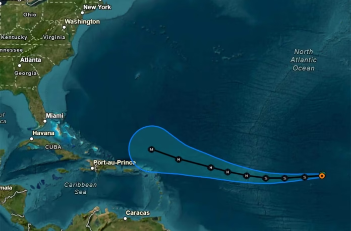
Tropical Storm Erin path is capturing widespread attention as the system intensifies over the Atlantic and moves westward. With sustained winds currently near 50 mph and forward motion of about 18 mph, the storm is projected to strengthen into the first hurricane of the 2025 Atlantic season within the next 24 to 48 hours.
Formed on August 11 off the west coast of Africa, Erin has quickly organized under favorable environmental conditions. Meteorologists are closely monitoring its trajectory as it moves over warm waters, which could help the storm intensify rapidly. Forecasts suggest it may reach Category 3 strength by the weekend, with potential winds exceeding 110 mph.
Current Position and Movement
- Location: Central Atlantic, roughly 1,000–1,300 miles east of the Northern Leeward Islands
- Wind Speed: 45–50 mph
- Direction: West at 17–20 mph
- Pressure: Estimated near 1,005 mb
The system is showing improved organization, with bands of thunderstorms wrapping around a more defined center. Satellite imagery indicates strong convection near the core, a sign of continued development.
Forecast Intensification
Erin is moving through an area of low wind shear and warm sea surface temperatures, both of which are ideal for tropical cyclone growth. Forecasters expect the storm to:
- Become a hurricane by Friday
- Potentially intensify to Category 3 over the weekend
- Maintain a strong and well-defined circulation over the next five days
While some fluctuations in strength may occur due to eyewall replacement cycles, overall conditions favor significant strengthening.
Projected Tropical Storm Erin Path
The forecast track shows Erin continuing westward before gradually curving northward as it approaches the western Atlantic. This turn is expected to occur due to a weakness in the subtropical ridge, allowing the storm to steer away from the Caribbean islands and move into open waters.
Likely path scenarios include:
- Passing north of the Leeward Islands — limiting direct land impacts but bringing rough seas and heavy surf
- Tracking toward Bermuda — depending on how soon the storm turns north
- Remaining offshore of the U.S. East Coast — though strong swells could still reach coastal areas
Potential Hazards
Even if Tropical Storm Erin stays far from land, several hazards remain possible:
- Dangerous surf and rip currents: Swells generated by Erin will likely affect portions of the Lesser Antilles, Puerto Rico, and the Virgin Islands within the next few days.
- Gusty winds: Outer rain bands could bring brief but strong wind gusts to nearby islands.
- Heavy rainfall: Tropical moisture may cause localized flooding in some coastal areas, especially if feeder bands linger.
Tropical Storm Erin Path Snapshot
| Feature | Status / Forecast |
|---|---|
| Current Winds | 45–50 mph |
| Movement | West at 17–20 mph |
| Expected Hurricane Status | By Friday |
| Potential Peak Strength | Category 3 by the weekend |
| Likely Path | North of Caribbean, away from U.S. mainland |
| Coastal Hazards | High waves, rip currents, possible flooding |
Atmospheric Steering Factors
The storm’s motion is influenced by a large area of high pressure over the Atlantic, guiding Erin westward. As this high weakens in the coming days, an approaching trough from the north will likely allow Erin to make its turn into the open Atlantic.
If the ridge remains stronger than expected, Erin could maintain a more westerly path for a longer period before turning north. This is one reason meteorologists advise constant monitoring until the turn becomes more certain.
Preparedness and Monitoring
Communities in the eastern Caribbean should remain alert, even if the center of the storm is forecast to pass north of the islands. Marine operators, especially in open waters, should be aware of rapidly building seas and strong currents.
For those along the U.S. East Coast, the primary concerns will likely be high surf, rip currents, and possibly enhanced tides later next week. While a direct impact currently appears unlikely, forecast changes are always possible at this range.
In summary, the tropical storm erin path shows a system steadily strengthening and on course to become a major hurricane. With a projected northward curve, it may avoid a direct landfall in the Caribbean or mainland U.S., but hazards like dangerous surf and strong currents remain a concern. Staying updated on forecast changes is key over the next several days.
Stay safe, keep watch on the latest advisories, and share your thoughts on how your region is preparing for the storm’s potential effects.
