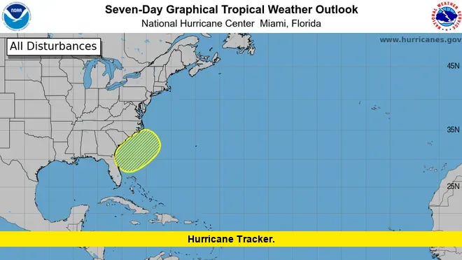
Central Florida residents are keeping a close eye on the hurricane tracker today as Invest 93-L becomes better organized and moves directly over the state. Early this morning, the system sat just off the Atlantic coast, slowly gathering strength and fueling widespread rain and gusty winds across the region.
With the National Hurricane Center (NHC) assigning a 40% chance of development in both the next two and seven days, authorities across Florida are cautioning against localized flash flooding. Even without official tropical depression status yet, the impact is already being felt in communities from Orlando westward, with several inches of rainfall expected throughout the day.
Invest 93-L: What the Hurricane Tracker Shows
The hurricane tracker highlights Invest 93-L’s current path as it traverses the Florida Peninsula. The system, characterized by disorganized clusters of thunderstorms and winds nearing 30 mph, is projected to reach the northeastern Gulf of Mexico by Wednesday. There, forecasters warn that environmental conditions could turn more favorable, increasing the odds of the storm developing into a tropical depression or even a named tropical storm, potentially Dexter, later this week.
Key Points Summary
- Invest 93-L is crossing Central Florida today, bringing intense downpours and gusty winds.
- Flood risks are high, with localized rainfall totals reaching 3-4 inches in some areas.
- The NHC reports a 40% chance of the system developing further as it enters the northeastern Gulf midweek.
- Flash flood watches and local advisories remain in effect across much of east and central Florida.
- Should Invest 93-L organize over Gulf waters, Louisiana and neighboring states may be affected by late week.
Flood Risks and Forecast: Central Florida on Alert
Heavy rain bands dominate Central Florida’s forecast, with up to 80-90% coverage for storms throughout the day. Thunderstorms packing gusts up to 50 mph could lead to tree damage or localized power interruptions. The Weather Prediction Center has placed much of the region under a Level 2 out of 4 flash flood threat as slow-moving storms pour tropical moisture over already saturated ground.
For residents:
- Monitor local alerts and emergency instructions.
- Avoid flooded roads and never attempt to drive through standing water.
- Stay updated on changing conditions as more rounds of storms are likely after Invest 93-L exits into the Gulf.
Weather models suggest the storm will continue impacting Florida with rain and possible severe weather through Thursday before the pattern shifts back to typical summer thunderstorms by the weekend. High temperatures today will be held in the upper 80s due to cloud cover, but humidity remains oppressive.
How the Hurricane Tracker Is Guiding Forecasts
Meteorologists are using the hurricane tracker and a suite of “spaghetti” models to assess the future path and intensity of Invest 93-L. While there remains some uncertainty about the system’s development over Gulf waters, all forecasts agree that both Florida and portions of the northern Gulf Coast will face continued rainfall threats through the end of the week.
Forecasters also note that every poorly organized system carries more uncertainty, and the community should stay alert for new advisories.
Stay Safe as Invest 93-L Moves On
As Invest 93-L brings unsettled weather to Florida, local communities, emergency services, and meteorologists are working together to keep everyone informed and ready. If you’ve experienced heavy rain or flooding, or have tips on preparing for storms, share your thoughts below. Your input helps others stay safe and aware as hurricane season ramps up.
